NYC Metro Area Weekend Forecast 11/25/22 – 11/27/22

Happy Friday! This weekend after Thanksgiving will be a mixed bag of weather conditions. Friday will see showers come to end and skies clear later this afternoon and evening. A beautiful day is expected on Saturday with plenty of sunshine and temperatures just above normal. Then rainy conditions are expected on Sunday afternoon and evening. Read below for a more detail forecast breakdown for each day.

Friday

A weak cold front associated with an upper-level trough will move through the region early today. Cloudy skies and showers will linger into early this afternoon. Then clouds will break for some sunshine during the mid-late afternoon hours and winds beging increasing, behind the cold front. High temperatures will be in the upper 40s to lower 50s throughout the area. Light southwest winds between 5 to 15 mph are expected through early this afternoon. Then winds should become more westerly with gusts up to around 25mph later this afternoon.

Mostly clear skies are expected tonight. A chiller airmass with blustery northwest winds move in briefly.  Temperatures will fall through the 40s this evening then into the 30s overnight throughout the region. Low temperatures will be in the upper 30s in urban NYC metro and in the lower to middle 30s in the suburbs.  Northwest winds will be between 15 to 25mph with gusts up to around 35mph for much of the night.

Saturday

High pressure will be in control on Saturday. Mostly sunny skies and less breezy conditions are expected. The airmass will moderating. High temperatures will be in the lower to middle 50s, which area few degrees above normal for this time of year. Winds will be out the the west between 5 to 15 mph with some gusts up to around the 20mph. Beautiful conditions and the vibes will be great.

ECMWF forecast model shows dry conditions with high pressure on Saturday

Dry conditions are expected Saturday night. Skies will remain mostly clear during the evening hours, then some high clouds will begin increasing later in the night, ahead of the next storm system for later Sunday.  Low temperatures will be in the upper 30s to lower 40s for much of the region.

Sunday

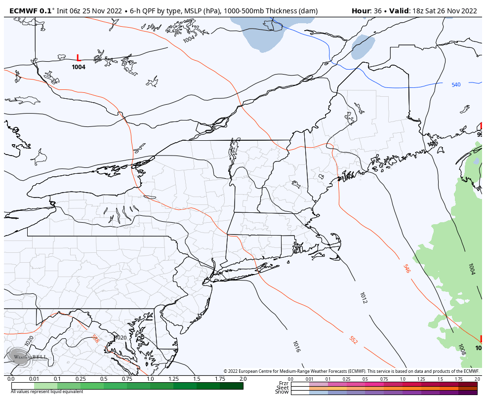
Mostly cloudy skies are expected on Sunday. A storm system will bring more showers or periods of rain to the NYC metro area during afternoon and evening hours. Some limited sunshine is possible early in the morning, but some showers may begin arriving late in the morning.

A strong southerly low-level jet with this storm system will enhance forcing and moisture in the area. Therefore, some periods of moderate or heavy rain are possible, which could cause some travel issues and minor flooding in poor drainage areas. But rainfall totals overall will be limited by the fast speed of this system through the area. Rain will begin tapering off late on Sunday night.

NAM forecast model showing periods of rain on Sunday afternoon and evening

This storm system will track northwest of the area and push a warm front northward. Temperatures will depend on how far north this front gets. But high temperatures may reach the upper 50s or lower 60s at least in NYC and coastal areas. High temperatures will in lower to middle 50s are more likely further northwest. Southerly winds will increase to 15mph to 25mph and may gust to around 35mph especially near the coast, during the afternoon and evening hours.

Brief Look at Next Week

High pressure will return with mostly sunny skies on Monday and Tuesday. Temperatures will trend cooler each day, then warming up again on Wednesday. The chance of rainfall will come with another storm system later Wednesday into Thursday.

Stay tuned for another forecast update here by Sunday evening.

July 4th Weekend Forecast Update: Strong to Severe Storms Possible Saturday PM

Happy July 4th weekend! Much of this holiday weekend will be fine for beach and fireworks festivities. But heat and humidity will be more oppressive today and a cold front could bring some scattered strong to severe thunderstorms on later this afternoon and evening. Then weather conditions improve for Sunday and some great weather is in store for Independence Day. More details on forecast for each day below.

Saturday

A prefrontal disturbance has been producing more clouds and showers in the region early this morning. But the clouds will likely break for more sunshine during late morning and early afternoon hours. This will allow for temperatures to rise into the upper 80s and lower 90s, again away from the coast. High dewpoints in the upper 60s and lower 70s will support heat index values in the middle or upper 90s. Sea-breezes will keep coastal sections a little cooler, but dewpoints will be the same or higher. Then more scattered showers and thunderstorms are likely to develop in parts the region during the mid-late afternoon and early evening hours, with the cold front approaching the region from the northwest.

A lack of large scale forcing and steep mid-level lapse rates with the front will reduce the risk for more widespread or significant severe weather later today. But the cold front could interact with any sea-breeze boundaries or remnant outflow boundaries from prior storms, which could enhance forcing in parts of the the region. Surface-based instability and bulk effective shear will also increase this afternoon, which can support some scattered strong to severe thunderstorms. These storms will be mainly capable of producing strong or damaging wind gusts and some hail. Any thunderstorms could also produce heavy downpours and frequent lightning. High precipitate water values (high moisture content in the atmosphere) may support torrential rainfall and flash flooding in a few locations.

The Storm Prediction Center has issued a Slight Risk (Level 2 of 5) of severe thunderstorms in the NYC metro area for today

Overall, much of today will just very warm and humid. Not everyone will necessarily see showers and thunderstorms. However, you should have a plan to head indoors in case any thunderstorms occur in your area. This front will be slowly moving through the area later tonight, so additional scattered showers and thunderstorms are possible. But the severe weather threat will diminish with instability waning after dark.

Sunday & Independence Day

The frontal boundary will be weakening further and pushing south into the Lower Mid-Atlantic region on Sunday. Some cloud cover and showers could linger into early morning hours, mainly over Central-Southern NJ and Southeast PA. But the vast majority of the day will be feature sunshine, a northwest breeze and lower humidity. High temperatures will likely reach the mid-upper 80s throughout the NYC metro region.

Independence day on Monday still looks like the best day of the holiday weekend. Expect plenty of sunshine and comfortable humidity all day. High temperatures will be in the mid-upper 80s again throughout New Jersey, Southeast NY, Southern Connecticut and Eastern PA. The weather shouldn’t have any impacts on outdoor plans or fireworks activities through the evening hours.

Model guidance blend shows high temperatures in the mid-upper 80s for much of the region on Independence Day

Meanwhile, Tropical Storm Colin has unexpectedly formed near the South Carolina coast this morning. It is a minimal tropical storm with maximum sustained winds at 40mph and isn’t expected to intensify due to high shear, as it tracks northeast over the Carolina coast and then out in the Atlantic Ocean. This storm will have not any rain or wind impacts for the NYC Metro region. But it could cause some rougher surf for the oceanside beaches late Sunday into Independence Day.

More active weather with some shower and thunderstorm activity expected during the middle of next week as few disturbances move through. But I will talk about that on Tuesday. Enjoy the holiday weekend for now, if you can!

NYC Metro Forecast: Tranquil Weather Mid-Week, July 4th Weekend Weather

Good evening! Any lingering showers or storms will taper off early this evening, as the cold front responsible shifts east of the region. Later this evening skies will clear, and humidity levels will decrease. Temperatures will fall into the upper 50 to lower 60s throughout the region late tonight. Dewpoints will in fall into the middle 50s and it will feel refreshing by dawn.

Tuesday through Friday

Mostly dry conditions are expected for the mid-late week period, as high pressure builds into the Northeast. Tuesday will be mostly sunny with light northwest winds and low humidity, which will make for a gorgeous day! A cooler airmass behind the cold front will keep high temperatures in the upper 70s to lower 80s throughout the region.

3km NAM model shows dewpoints in the 50s Tuesday afteroon!

A weak cold front associated with an upper-level trough will approach the region on Wednesday. More clouds will mix with sunshine, but moisture will be limited for any showers. Thus, Wednesday will likely be decent day. A light southerly flow ahead of the front will help temperatures rise into in the middle 80s, except near south-facing shore areas.

On Thursday and Friday upper-level ridging builds into Northeast and high pressure at the surface begins set up near Bermuda. This will result in more west-southwest flow and temperatures rising into the upper 80s to lower 90s with mostly sunny skies through the region. Humidity will also begin increasing by Friday.

July 4th Weekend

Very warm and humid conditions are likely start of the holiday weekend on Saturday. But an upper-level low swinging over SE Canada will cause a stronger cold front to approach the region from the northwest. This front will likely trigger some showers and thunderstorms, especially the afternoon and evening hours. Somewhat stronger wind fields and instability could support at least a marginal risk for strong to severe thunderstorms. Although a washout is not expected on Saturday, these storms could create issues for any outdoor plans or fireworks activities.

ECMWF model shows showers and thunderstorms with a cold front Saturday afternoon and evening in the Northeast.

Sunday’s weather forecast has the most uncertainty. At this time, the front appears to push south of the region. Any leftover showers early in the morning, will give to clearing skies for rest of day. High temperatures will likely reach the low to mid 80s. However, if the front is slower to push south, we could see another round of showers and thunderstorms develop in the afternoon. So this forecast may be fined tuned as we move closer.

Monday July 4th Independence Day currently looks like the best day of the holiday weekend. Mostly sunny, skies low humidity and high temperatures in low to mid 80s are expected with the cold front forecast to be farther south of the region. It will be good day for the beach, park, or barbeque in the backyard.

That’s it for now. There will be another update on the forecast for the July 4th holiday weekend around Thursday.