Suprise Snows after Heavy Weekend Rains

A narrow, band, behind a a cut-off low brought surprise snowfall 2″ – 6″ for parts of Central Long Island and Central Connecticut, this morning. Even thundersnow was reported over at Islip, NY, with snowfall rates up 3″ per hour and visibility down to 1/8th  of a mile. The rest of the area saw rain mix or change to some wet snow and sleet, when more intense rates of precipitation  at times. This was due to colder air aloft, being dragged down to the surface. But little or no accumulation occurred.

OKX radar showing narrow frontogentic band over Central LI and CT
OKX radar from wunderground.com showing narrow frontogentic band over Central LI and CT

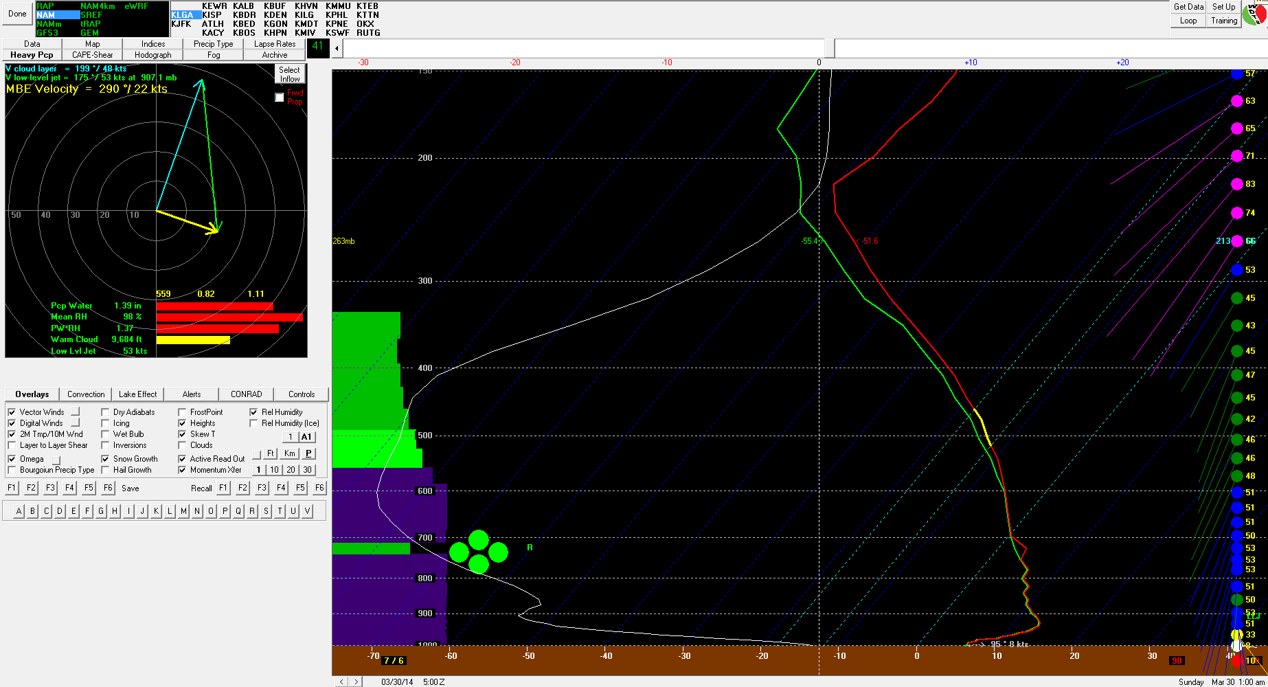
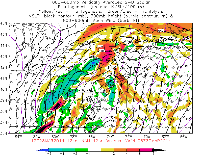
So what caused this heavy snow band? One cause for this some frontogenetic forcing occurring behind the cut-off low.  Another cause was instability.  The OKX sounding was unstable with mid-lapse rates over 7.0 C/km. This produced convective banding with thunder over Central LI and CT :

OKX sounding at 12 UTC time. Showing steep mid-level lapes rates
OKX sounding at 7am time, showing 3-6km agl and 700-500mb lapse rates 7.0 C/km and higher

Models showed this the last 3 days, showed that this band would form. But they were less consistent, on the timing, and placement. As well amount of dynamic cooling that would need to occur for snow to accumulate. Add on that it’s end of March, when it’s typically more difficult to get boundary temperatures to support snow. Especially along the coast. So considering those factors, it just wasn’t a likelyhood and a good move beforehand to forecast 2″-6″ for any specific area. Despite the outcome. However, we can use what we  learned from it, to improve forecasts in the future.

This cut-off low also gave us heavy rains and thunderstorms, this past weekend. Many received between 1.50″ to 3.00″ of rain.  As discussed in the previous blog post, a 50-60kt low-level jet move through area with pwats over 1.00″. This enhanced deep moist convergence, along a warm front over eastern parts of LI and CT most early Sunday morning. Causing elevated convection to train over these areas and increase rainfall totals to 3.50″ – 5.50″

dlcp_14033004

Heavy Rainfall Likely Saturday Night

As I discussed previous post heavy rainfall is likely weekend. Particularity during Saturday night. Latest guidance is showing rainfall totals between 2″ – 3″ for much of the area. With locally heaver amounts between 3″-4″. Especially N&W of NYC.

The 12z NAM today has area of very heavy rainfall moving through NJ, SE NY and CT between 7pm – 1am Saturday night. Bukfit sounding for LGA shows a 50-60kt LLJ, pwat near 1.35″ and a large of strong omega.  There is also an area 600-800mb frontogenesis moving through the area tomorrow night. All this translates into strong lift and high moisture content over the area. Strong winds aloft are being prevent from reaching the due to strong inversion near the surface. However, downpours could bring down some portion of these winds down to the surface.

Bukfit sounding for LGA 12z NAM shows a 50-60kt LLJ, pwat near 1.35" and a large of omega
12z NAM Bukfit sounding for LGA  shows a 50-60kt LLJ, pwat near 1.35″ and a large of omega
12z NAM showing 600mb-800mb frontogenesis Saturday night

The 12z ECMWF is also showing a 50kt+ LLJ and moving pwats over 1.25″ – 1.50″ through tomorrow night. Another aspect of this storm that needs to be watch frontogentic forcing  and elevated instability, behind the upper-level low Sunday afternoon and night.The 12z NAM shows enough dynamic cooling and cold air advection, for rain to change wet snow. Especially for inland areas. At this time, I am skeptical of this solution. But it’s not impossible to happen.


Record Lows Followed By Rainy Weekend

Record low temperatures were set this morning in the following locations:

LGA 23 Old Record 24 in 1975
JFK 23 Old Record 24 in 2001
ISP 22 Old Record 22 in 2001
EWR 22 Old Record 23 in 2001

We recovered nicely into to lower and middle 40s this afternoon. Which is still 10 degrees below normal. Party cloudy skies are expected tonight. Then it will mostly cloudy tomorrow morning. A cold front will move through the region tomorrow evening. Ahead of is 50kt-60kt low-level jet and precipitable water values (pwats) around .75″. This could some showers to develop tomorrow afternoon and evening. Heavy rainfall is not expected however. Amounts .25″ at best likely.

Shortwave energy will cut-off to our southwest on Saturday. As this system approaches our area, rain moving in from south to north. Rain is likely fall heavy times Saturday night into perhaps Sunday. 200mb-500mb jet streaks are positioned favorably for upper-level divergence (forcing). The cut-off low intensifies and takes negative tilt over Ohio Valley. This causes surface low pressure to form along the coast. Warmer, moist air will be transported with developing low-level jet. The heaviest rainfall is likely to occur with the best moisture convergence setup near the low-level jet and pwat axis. As the 18z run of the GFS shows for Long Island and Connecticut:

18zgfsNE_850_spd_06018zgfsNE_con_pwat_060Overall it seems most areas are likely to receive at least 1-2″ of rain from this storm. With parts of the area receiving up to 3 or 4 inches of rain. Winds may also gust between 35mph to 45mph, near the coast on Sunday, with low-level lapse rates steepening and low-level jet in the area.The pattern will remain progressive overall with a parade of Pacific systems coming into Western and Central US. This will force this storm to move out of the region by Monday. With fair weather returning for much of next week. Temperatures will also be closer to normal in the 50s and 60s for highs.

The 12z GEFS hints another large storm system over Eastern US, about a week from now. However, with the polar vortex retreating into North Pole, artic/polar air source, will likely be shutoff next week.  We may see Pacific shortwave energy to cut-off again and bring more heavy rain to the area. Still very far out for any details: 12zGEFSf192