Traquil Conditions Through Early Next Week

A series of disturbances will be moving across the across the nation early next week. But the flow is too progressive for the northern and southern streams to phase. Temperatures will also moderate towards the end of week, as a more zonal flow develops. High temperatures will could reach near 50 degrees on Saturday. These temperatures are actually close to average for early March. But it will feel much better than frigid temperatures, we have seen so far this week.

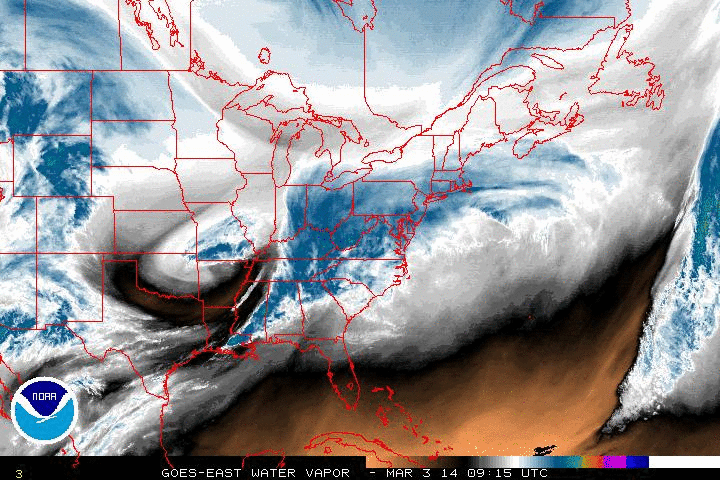
A strong southern stream disturbance will cause a low to develop over the Gulf of Mexico on Thursday. Then this low will track off the Southeast US coast on Friday. Current model guidance doesn’t show any northern stream interaction. A trough moving into Central US, will also prevent this low from turning north up the coast. So only some high clouds are expected from this system Friday night, as it lows to our well to our south and east. The NAM and GGEM show this storm coming close enough to brush the coastal with some rain. But these model solutions are likely too amplified, given the progressive nature of the pattern.

A cold front will approach the area on Sunday with chance of rain or wet snow showers.  Behind this front, temperatures will average slightly below normal, early next week. Our storm chances will increase later next week with a new ridge building on the West Coast and  energy ejecting out Southwest US.  How these storm chances will evolve for us, will depend alot on the positioning and strength of the ULL or polar vortex over Canada. Which will we likely see various model solutions on, through this weekend.

0zECf168

Lobe of Polar Vortex Suppresses Winter Storm

Much of tri-state area, escaped this winter without seeing a significant snowfall. Parts of NW NJ, Lower Hudson Valley and CT, saw no accumulation. The reasons for this, were discussed in last two posts, before this one. However, now you see it happening on water vapor loop this morning. The drier area dropping over the Great Lakes and Northeast, is strong confluence flow behind associated with a lobe of polar vortex. This is currently  shearing and suppressing this storm to the south and east of us.

5wv-animatedAs this happening another bitterly cold airmass coming into region. Tonight the NAM show temperatures possible dropping into single digits over NYC and NW suburbs tonight, with a northerly flow. New record lows could be set again, tomorrow morning. Especially at the airports.

New Snowfall Map for 3/02-3/03

FinalSnwofallmap0303

This morning’s 6z and 12z NAM, RGEM, GFS guidance today has trended further south this storm. The latest HRRR runs also supports this trend. Total qpf totals for Northern NYC are now in .10″ -. 25″ range. With less north and more south. Current radar, water vapor imagery, and observations, don’t give me much reason doubt these solutions. Also some warmer temperatures, may support more wet snow,sleet, rain at onset. Especially over Southern New Jersey. The cause for the continue trend further south, is the lobe of the PV, dropping down faster into Great Lakes and Northeast regions and suppressing this
southern stream wave.

Along with the south trend, is also a trend to end the storm faster everyone. For NNJ,NYC, LI snow may tapering off to flurries by sunrise tomorrow morning. While steadier snow continues further south into late morning or early afternoon hours tomorrow.

So for all those reasons, snowfall totals have been adjusted downward everywhere. And it’s possible this is still too high for some areas. Just to note, the ranges in general, are from lowest to highest; from north to south. For example: Staten Island, is more likely to see 3″ or 4″ than 5″ or 6″. While Philadelphia is likely to see at or either side close to 6″.