First Atlantic Tropical Storm Possible off the Southeast US

The National Hurricane Center is watching a disturbance of the SE coast of the United States, to become first tropical storm of Atlantic Hurricane Season. Their latest tropical weather outlook at 2pm Sunday, gives a 60% chance of tropical storm formation over next 48hrs. If it becomes a tropical storm, it will be named Arthur:

2pmatl1
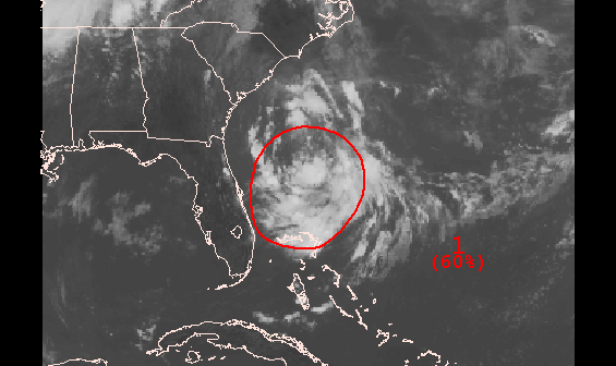
Currently this disturbance has a broad low-level center, with northerly shear displacing convection to the south and east of center. The shear is being caused by an deep upper-level trough over Western Atlantic. This trough will be replaced an upper-level ridge early this week. Which will result in a more favorable upper-level environment for further organization, as the disturbance tracks slowly south or southwest over over next few days.  Then later in the week,  this storm will begin track northeast, ahead of next trough and cold front approaching from the west.  For the New York Tri-state area, the model consensus at this time, keeps this storm far enough offshore, that any impacts would be very minimal for the July 4th holiday weekend. Some rough surf, at the beaches. But not much else. If the cold front and trough is slower and deeper, this may allow the storm to track closer to our area. However, this scenario is unlikely with no high-latitude blocking. Stay tuned for more blog updates on any new developments with this disturbance this week.

Warm, Humid & Storms Today. More Rain & Storms Possible Wednesday Night & Thursday

With a southerly flow, today will be warmer and more humid for Tri-State area. Temperatures will rise into middle to upper 80s this afternoon, away from the coast. Scattered showers and thunderstorms will develop along trough axis approach from the west this afternoon. Best chances for showers and thunderstorm will be north and west of New York City, where lift and instability will be higher. Model forecast soundings show sufficient SBCAPE for thunderstorms to become strong this afternoon. However, weak vertical shear and poor mid-level lapse rates will limit storm organization and intensity. Also with the weak flow and PWAT near 1.80″, any thunderstorms will be moving slowly and capable of producing very heavy rainfall. Which could result in some flash flooding. Showers and thunderstorms should gradually diminish tonight. As the trough axis shifts east and instability decreases after sunset.

6z NAM model sounding for Trenton, NJ late this afternoon, for high SBCAPE, weak shear & pwat 1.77"
6z NAM model sounding for Trenton, NJ late this afternoon, for high SBCAPE, weak shear & pwat 1.77″

Tomorrow we will see more sunshine. But it will not be as warm and humid. A weak cold front will slowly pass through the area. Temperatures will still take run at 80 or above, with a deep NW flow and steepening lapse rates. A strong cap aloft will likely suppress shower and thunderstorm development during the afternoon and early evening hours.

6z NAM showing strong capping inversion tomorrow
6z NAM model sounding showing strong capping inversion tomorrow

Later tomorrow night into Thursday could get more stormy. A potent shortwave and wave low of pressure that will producing severe weather over Central Plains today and Ohio Valley tomorrow, will moving across our region. There are some models differences on the exact timing and track of this wave through our area. If this wave, tracks over Central or Southern New Jersey, it could give many of us period of heavy rain with embedded, elevated thunderstorms. A track further north than that, would put more of the in warmer, unstable airmass and vertical wind shear. Which would support strong to severe thunderstorms. At this time, much the guidance favors the southern track. But as the begins develop over Central Plains today, this could still be some changes. Stay tuned for another update late tonight or early tomorrow.