An anomalous cold closed upper-level low swinging over the Great Lakes, will cause another period of stormy weather early this week, in Northeast and Mid-Atlantic. A deep southwesterly flow ahead of this system, will provide moisture feed out the Gulf of Mexico and Atlantic. The Storm Prediction Center has again issued a slight risk for the local tri-state area on Monday. That means they are anticipating some organized severe thunderstorms. But not widespread in coverage and violent in intensity.
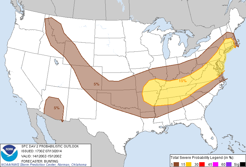
The main threat, from any of these storms Monday will be flash flooding, damaging winds Large hail is possible. But poor mid-level lapse rates and high freezing levels shown on model forecast soundings, will keep this threat lower. A warm frontal boundary will develop over the local region on Monday. This will cause winds the low-level winds to back from south-southeast at the surface to southwest aloft. For areas near the coast, including NYC, there will be more of marine influence that may keep thunderstorms under severe levels. But areas further inland, may heightened risk for isolated weak tornado. Especially over the Lower Hudson Valley.
On Tuesday, as the upper-level low moves further east, shear and lifting will increase. Without much capping in the atmosphere, showers and thunderstorms could be more widespread and frequent through the area. But this may also act to keep instability lower across the area for thunderstorms to become severe. Flash flooding is likely to be a bigger threat. Very high precipitable water values and some unidirectional shear will causes thunderstorms to train and produce torrential downpours in parts of the area. Stay tuned for another update tomorrow for this threat.

[…] ← Severe Weather & Flooding Threats Monday & Tuesday 7/14- 7/15 […]