A tropical disturbance about 170 miles east of Barbados, that has been struggling with dry air this week, has developed enough convection to be upgraded to Tropical Storm Bertha. As of 5am EDT, maximum sustained winds at 45mph and it moving west-northwest at 20mph. Tropical Storm Warnings have been issued the lower Lesser Antilles and Puerto Rico and Virgin Islands. The National Hurricane Center forecasts Bertha to track northwest into Northeastern Caribbean over the next three days, as a tropical storm. Then gradually turn northeast into the open Atlantic by five days, with little change in strength.
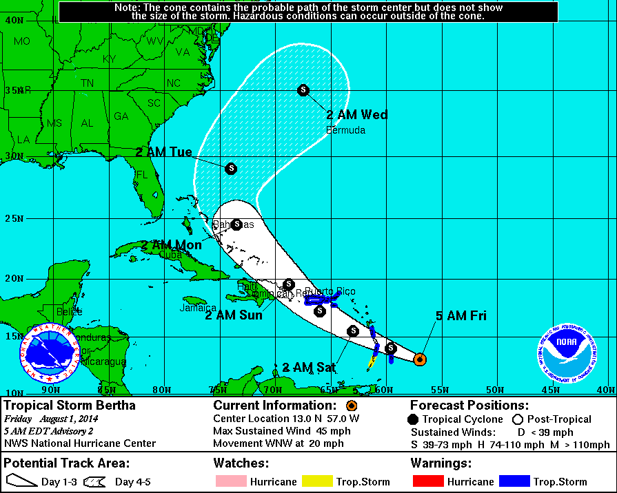
Currently Bertha is producing intermittent bursts of convection, that being are prevented from wrapping around the center of circulation, due to strong upper-level shear. Some dry air is entrainment, is also inhibiting more persistent convection. Bertha is likely remain in in a hostile environment over the next three days, as upper-level trough continues produces strong shear Eastern Caribbean. Then Bertha is likely to interact with the mountains of Hispaniola. Therefore little change in strength is expected and it is possible that Bertha may weaken to a tropical depression or tropical wave during this period.

In about 3 days, what remains of Bertha will reemerge over the Bahamas. It may be under a more favorable environment for intensification. In 4-5 days it will become more underneath the influence of a trough over the Eastern United States. At this time, all of the model guidance shows this trough, forcing Bertha to recurve somewhere midway between the U.S. East Coast and Bermuda. This would spare both regions from any major impacts. The lack of high-latitude blocking or a stronger Western Atlantic Ridge, during this time frame, strongly supports this scenerio, as well.
However, much of the guidance also shows Bertha becoming a strong tropical storm or minimal hurricane after 72 hours. If Bertha were to remain a weaker system, it would feel less influence from the trough and might track further south and west. While only having relatively minor impacts along the US East Coast. It’s also possible question, Bertha interacts enough with trough to produce more heavy rainfall along East coast early next week, without ever making landfall along the US East Coast. This scenarios have a low probability of occurring. But are worth continuing to monitor Berth for.
