Major Hurricane Odile Threatens Baja California, Hurricane Edouard No Threat to Land

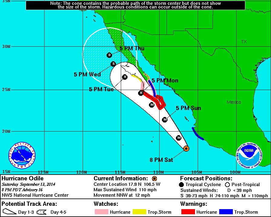
9/15 7:00am EDT Update: Odile made landfall near Cabo San Lucas, Mexico as major category 3 hurricane with maximum sustained winds at 125mph at about 925pm PDT overnight. An automated station on Cabo San Lucas reported a sustained wind at 89mph anda gust 116mph. As of the 5am Advisory, Odile is still moving north-northwest over the Baja California and has winds of 115mph. It will continue to weaken today over land. Edouard is now a category 2 hurricane with winds at 105mph. Edouard is likely to become the first major Atlantic hurricane of the season and remains no threat to land.

This post is update to previous post overnight on these storms:

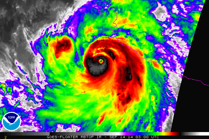
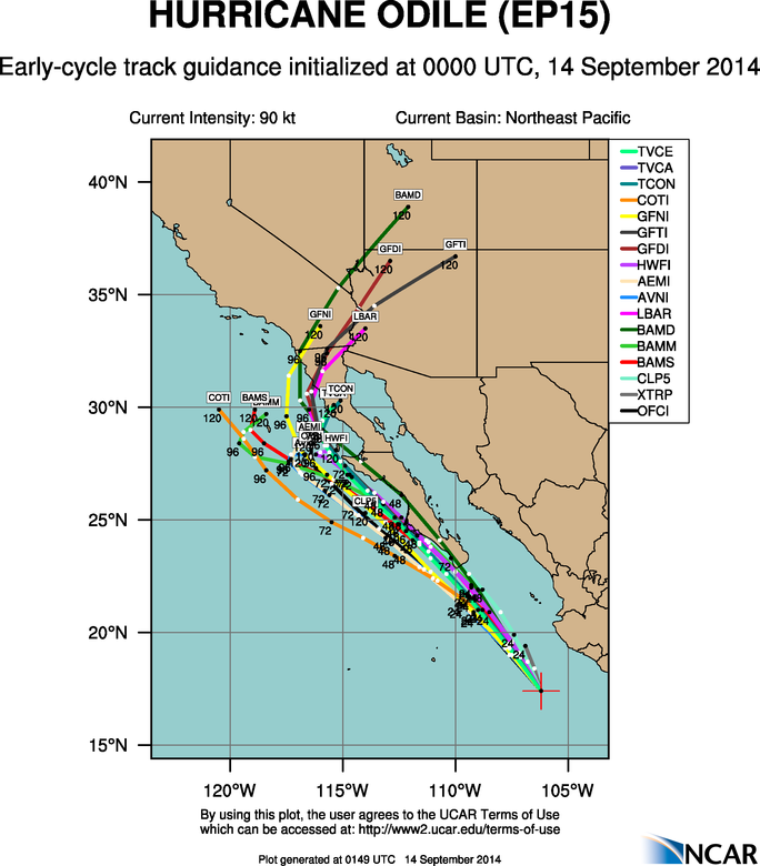
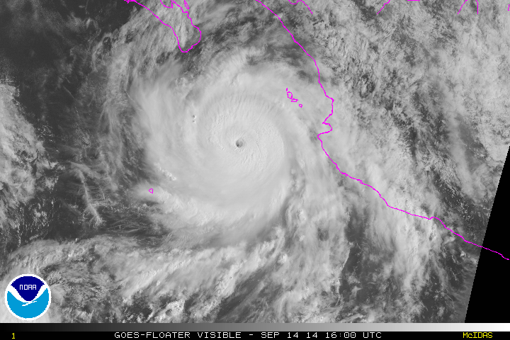
Odile continued to rapidly intensify overnight. It’s now major category 4 hurricane with maximum sustained winds at 135mph and is moving northwest at 14mph. It continues to be a threat to Baja California.  The storm appears to now have a double eyewall and will likely go under an eyewall replacement cycle soon.  Little in change in strength over next 24 to 36 hours, as comes very close to southern tip of Baja California. An aircraft reconnaissance is on route to the storm and should have a better assessment on the intensity. Hurricane warnings now stretch further to Punta Abreojos on the west coast of Baja California. Odile is expect to rapidly weaken, once it moves over cooler sea-surface temperatures off the central west coast of Baja California:

 vis0
145811W5_NL_sm

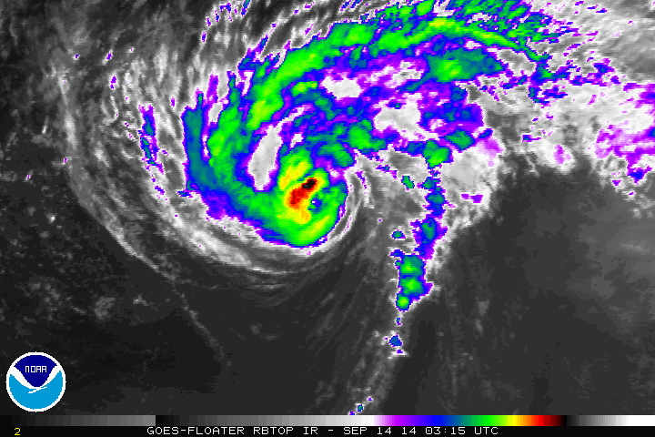
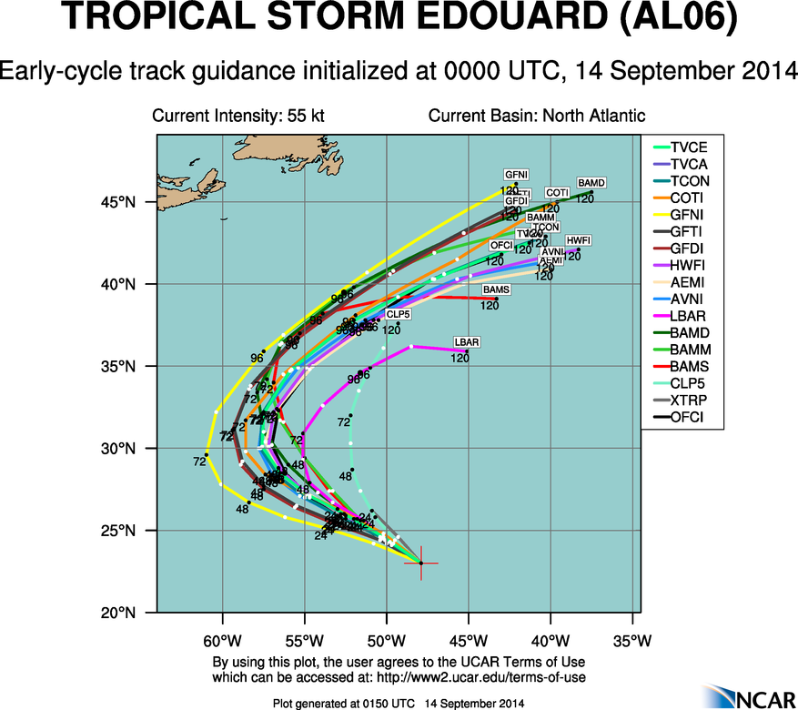
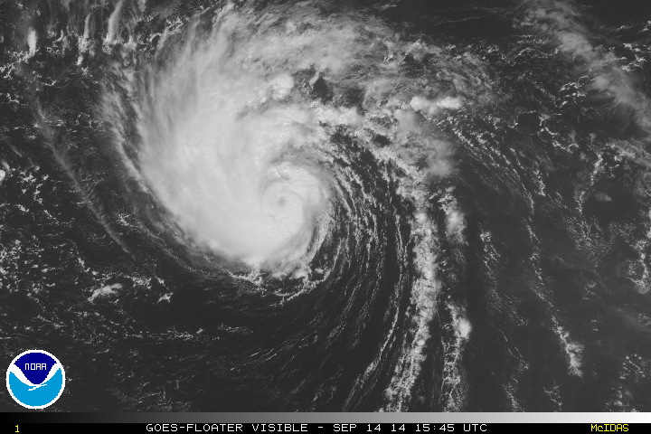
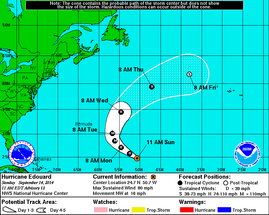
Edouard has become a category 1 hurricane in the Central Atlantic. The fourth hurricane of the Atlantic hurricane season. Maximum sustained winds are 80mph and it currently moving to the northwest at 14mph. An eye has become more visible in satellite imagery, over the past several hours. Edouard is now forecast to become a major category 3 hurricane. But it will remain no threat to any land. A large, deep trough over Eastern US and Western Atlantic will force Edouard to turn to north than northeast this week:

vis0

145744W5_NL_sm

Rest of the tropical Atlantic looks quiet right now. Some medium to long-range models show tropical systems developing in the Caribbean or the Atlantic. However these models have low reliability, at this range and solutions could vary from run to run. People need to use extreme caution, using these model forecasts.

Auroras Brighten the Northern Skies

On Wednesday, Sept. 10th the sun released a X class solar flare. This reached the earth and caused auroras (otherwise known as northern lights), over parts of Northern Hemisphere over past few nights. These are some spectacular and beautiful pictures from observers that were tweeted from Observing Space from Friday night:

Mt. Washington Observatory in New Hampshire. Credit: Ryan Knapp
Mt. Washington Observatory in New Hampshire. Photo Credit: Ryan Knapp
Burntcoat, Nova Scotia.  Photo Credit: Tim Lingley
Quebec, Canada. Photo Credit: Patric Nadeu
Burncoat, Nova Scotia. Photo Credit: Tim Lingley

Tropical Update 9/14/14: Edouard Out to Sea, Hurricane Odile Threatens Baja California

8:35am 9/14 Update: Odile is now major Cat 4 hurricane with 135mph winds. Another post coming later today.

Just another update on the tropics both in the Atlantic and East Pacific

Tropical Storm Edouard is about 1000 miles east-northeast of the Leeward Islands. Edouard has intensified with current maximum sustained winds at 65mph and has turned to the northwest at 14mph. All model guidance continues show to Edouard recurving into open North Atlantic over next 4 to 5 days. Perhaps becoming a Category 2 or 3 hurricane, as it continues to move over warm sea-surface temperatures and more favorable upper-level environment.

rbtop0

aal06_2014091400_track_early

Invest 92L is now the Gulf of Mexico. But has become less organized with low-level center less defined and lack of convection. Strong northeasterly wind shear and dry air intrusion is now expected to prevent further development of this disturbance.Convection has diminished with Invest 93L in the East Atlantic. Dry, sinking air around this disturbance, is now likely to prevent further development.

Without any threats in Atlantic, our attention turns to East Pacific again. Hurricane Odile is rapidly strengthening and is now a major threat to Baja California. As of the 8pm PDT advisory from the National Hurricane Center, Odile is moving to north-northwest at 12mph with maximum sustained winds at 110mph. Making a strong catergory 2 hurricane. It’s is forecast to become a major category 3 hurricane and track very close to the west of southern Baja California, late on Sunday and Monday. Hurricane warnings have issued for the region, including Cabo San Lucas. It is possible Odile could become even stronger and track even further north and east over the southern Baja Peninsula. After Monday, Odile is expected continue to track north-northwest just west over the central Baja California and gradually weaken to a tropical depression as it moves over cooler waters. Some model guidance also take remnants of Odile into parts of Northern Baja Peninsula and the Southwest US later next week. All interests in the Baja Pennisula should keep an eye on Odile this week. People in the hurricane warned and watched areas should take immediate precautions.

rbtop0

8pm PDT Track

aep15_2014091400_track_early