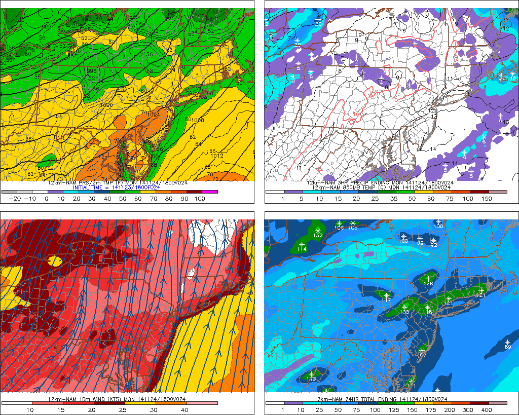
Latest models guidance has shifted track of this storm further west. Particularly the lows at 700mb, 850mb and surface levels. This will allow from more warm air-intrusion in mid-levels due a stronger southerly jet moving over more the area. Areas farther west farther west of I-95, will see rain or wintry mix change over to snow later this morning or early this afternoon. Which could fall heavy at times this afternoon or evening. Along I-95, include New York City metro area, rain should changeover to snow by early afternoon. But as this storm moves closer, warmer air intrudes aloft. This cause snow to change to sleet for several hours this afternoon. This will significant reduce snowfall totals. Further SE, warmer boundary layer temperatures will precipitation mainly in form rain with perhaps a little snow or sleet mixed in at times. Winds out of the northeast increase will also increase this afternoon to between 15mph to 25mph with gusts to 35mph or 40mph near the coast. Then turn more north at same speeds this evening. Some minor tidal flooding is possible at high tides this evening along the north facing shores.
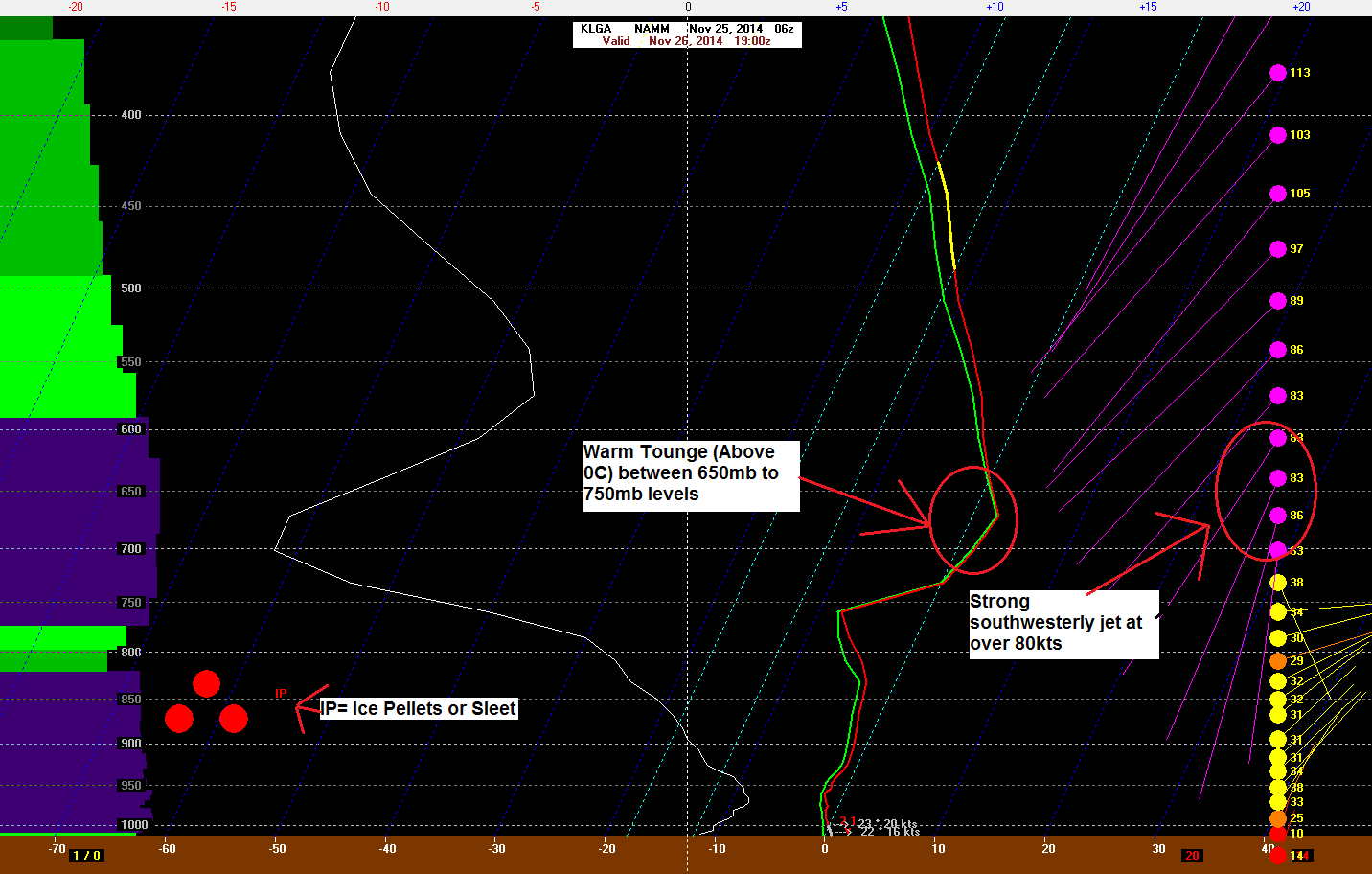
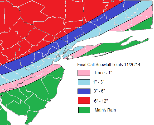
6z NAM showing the 700mb closed to the west and 60kt+ southwest winds over the coastal plain6z NAM forecast sounding 1pm today at LaGuardia Airport, NYMu Final Call for Snowfall total issued at 7am EST
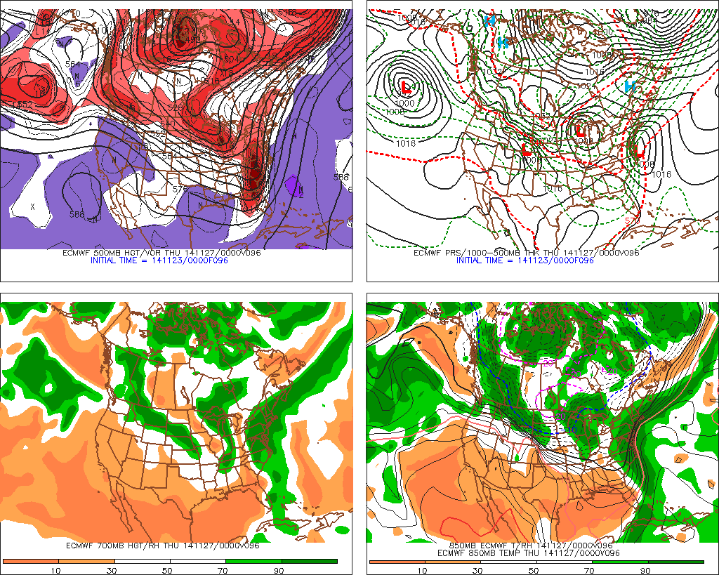
Most models are agreement on the Nor’easter for on Wednesday. The ECMWF model shows less phasing and has shifted the surface low and mid-level lows to the east. The result is a colder solution for the area with developing TROWAL (trough of warm air aloft) causing mid-level frontogenesis for moderate to heavy rates of snowfall. This will be monitored, as it could result in more cooling of the boundary layer and higher snowfall totals along the coast.
For now, I expect precipitation will move during the morning hours. The column will be warm enough for rain over the coastal plain at the start. But as frontogenetic forcing increases, this will change to quickly snow in a few hours. During afternoon hours snow could be moderate to heavy at times. However, surface temperatures may between 34-35 degrees. Which will impede on snowfall accumulation. Over Long Island and CNJ south , snow may change to sleet or rain, before ending as snow Wednesday night. This will reduce snowfall accumulations here even more. For the interior this should be all snow event, with accumulations occurring through the day. Highest snowfall totals are likely for these areas. Another update will come early tomorrow morning:
A deepening low pressure will track into from Central Plains into Western Great Lakes today and tonight. The warm front with moving northward tonight over Mid-Atlantic States. A strengthening southwesterly jet at 850mb to 950mb, help push warm front through region with overnight and early tomorrow morning some rainfall. Precipitable water values increase to over 1.5″, could lead heavy rain at times. Some elevated instability could also support some isolated thunderstorms.
HRRR model showing rain with embedded heavy downpours moving through the area tomorrow morning
Winds also increase later tonight, with the low-level jet overhead. Models show a weak inversion layer around 900mb, that would prevent strongest winds over 70kts from mixing down to surface. But there winds around 950mb level are at 50kt to 60kts. Heavy rain or isolated thunderstorm could help bring some these winds down to surface. A wind advisory for Long Island, Queens and Brooklyn. Winds are expected to be sustained between 20 to 30mph with gusts to 50mph over New York City and Long Island.
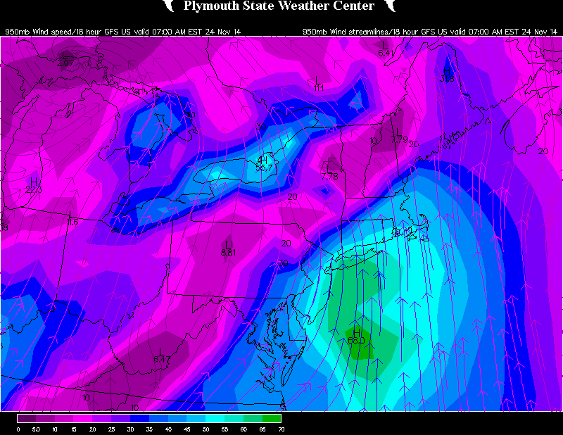
The 18z GFS showing wind 950mb (2000 feet) at 50k to 60kts over NYC, Long Island, and Eastern NJ
This rain will should end early tomorrow morning as the warm front pushes north of the tri-state area. Clouds should break for some sunshine during the afternoon. We will be in warm sector with strong southwest flow and 850mb temperatures rising to between 12C to 16C during the afternoon hours. This will support unseasonably high temperatures at least in the middle to upper 60s, with mostly cloudy skies expected. If clouds break sunshine tomorrow afternoon, temperatures could rise into lower to middle 70s. Some record highs for tomorrow, may also be in jeopardy.
18z NAM showing temperatures near 70 over Central New Jersey tomorrow afternoon with a strong Sw flow
However, this warmth will be short-lived. A cold front will move across the area tomorrow night. This bring a cooler airmass into the Tri-state region on Tuesday. High temperatures will be in the lower to middle 50s with some sunshine. Which is still several degrees above normal. A stronger cold front will move slowly through area Tuesday night and Wednesday. There will be area an of low pressure developing along cold front to south. This low will turn into a Nor’easter and track up quickly up the East Coast Wednesday afternoon and night. This low will bring some significant precipitation and high winds across the area Wednesday afternoon and Wednesday night. The track, intensity of this low will depend on amount interaction or phasing of polar, pacific, southern disturbances. The 12z GFS tracks thjs storm near or just east of 40/70 benchmark. So that surface N-NE and warm-air advection in mid-levels is weak enough that much of Tri-state area will see an accumulating snow. 12z ECMWF has low track very close NJ and Delmarva coasts, then northward over Long Island and New England. A strong southerly mid-level jet streak associated with storm moves other area. This brings a surge warm-air of aloft that causes any snow to mix with sleet and rain for areas just I-95 corridor. Long Island and NJ shore would likely see mostly rainfall. With perhaps change to snow at the end, as the storm passes to north. Highest elevations of NW NJ and Lower Hudson Valley may still see snow for most of the event, unless the track shifts further west, in future runs.
The 12z ECMWF showing more phasing of disturbance causing a deeper low to hug the coast and bring more warmer air aloft
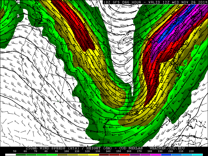
Very strong upper-level streak over 190kts at 250mb, will also support storm deepen rapidly near the Mid-Atlantic coast or over New England. This will also help expand more precipitation to northwest of storm. A few things we need watch for are some strong dynamics and a warm boundary layer. Mid-level frontogenesis might keep heavy snowfall rates and dynamic cooling, before that changes over to sleet or rain. Or behind the storm, a comma-head or deformation band forming with temperatures at surface and aloft crashing and closing off 500mb and 700mb lows. Boundary level or surface temperatures may be issue if the cold arrives more slowly on Wednesday. Sea-surface temperatures just offshore, are running above average for this time of year. So if winds are more out of the northeast to east direction, this will bring warmer air into the coastal regions. These are all possible scenarios. I will have another update on this storm once the 0z runs come out.
18z GFS showing a divergent phased jet streak streak over the Eastern United States at 250mb (35,000 ft)