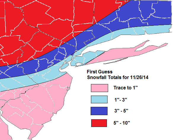
Most models are agreement on the Nor’easter for on Wednesday. The ECMWF model shows less phasing and has shifted the surface low and mid-level lows to the east. The result is a colder solution for the area with developing TROWAL (trough of warm air aloft) causing mid-level frontogenesis for moderate to heavy rates of snowfall. This will be monitored, as it could result in more cooling of the boundary layer and higher snowfall totals along the coast.
For now, I expect precipitation will move during the morning hours. The column will be warm enough for rain over the coastal plain at the start. But as frontogenetic forcing increases, this will change to quickly snow in a few hours. During afternoon hours snow could be moderate to heavy at times. However, surface temperatures may between 34-35 degrees. Which will impede on snowfall accumulation. Over Long Island and CNJ south , snow may change to sleet or rain, before ending as snow Wednesday night. This will reduce snowfall accumulations here even more. For the interior this should be all snow event, with accumulations occurring through the day. Highest snowfall totals are likely for these areas. Another update will come early tomorrow morning: