Heavy Lake Effect Snows for Western NY, Record Lows Possible Wednesday

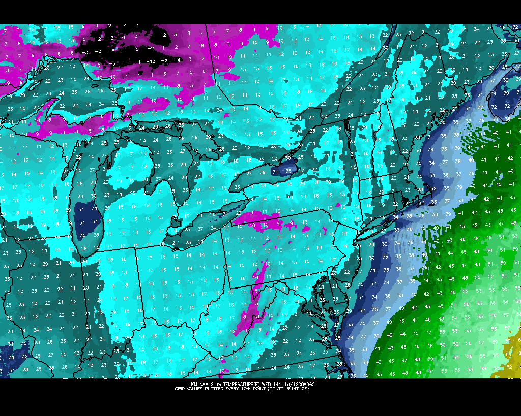
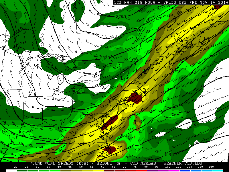
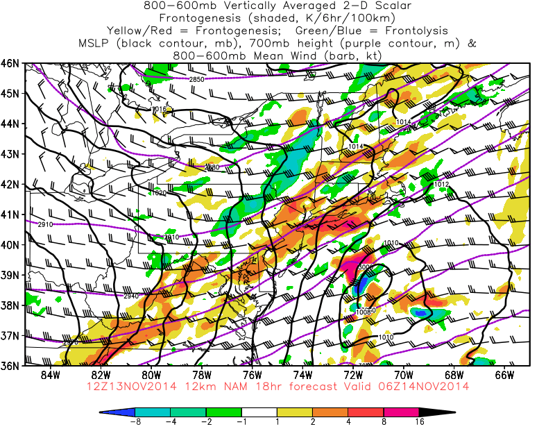
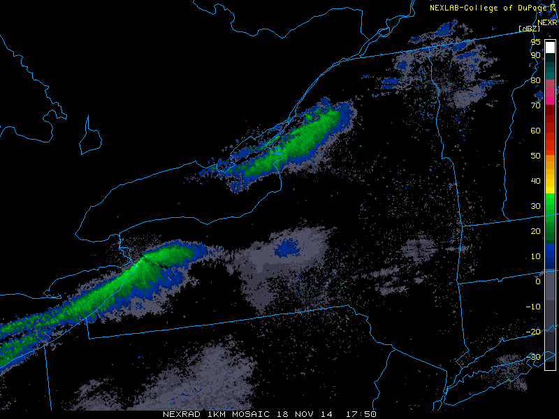
Very cold air arriving over Northeast, has caused very heavy snow bands to off the warm Great Lakes in Western NY. There have been two persistent bands, since last night. The first band has come off Lake Ontario and into Watertown,New York area. The second band has setup off Lake Erie to just south of Buffalo, NY. Some places have reported 3-4 feet already. The Buffalo National Weather Service office is forecasting up 5 to 6 feet of snow in some areas. Check out some fascinating time-lapse video below of snow falling over Lake Erie:

New_York.rad

PUBLIC INFORMATION STATEMENT
SPOTTER REPORTS
NATIONAL WEATHER SERVICE BUFFALO NY
908 PM EST TUE NOV 18 2014

********************STORM TOTAL SNOWFALL********************

LOCATION          STORM TOTAL     TIME/DATE   COMMENTS
                     SNOWFALL           OF
                     /INCHES/   MEASUREMENT

NEW YORK

...ERIE COUNTY...
   1 SE LANCASTER        60.0   600 PM 11/18  SOCIAL MEDIA
   GARDENVILLE           60.0   800 PM 11/18  TRAINED SPOTTER
   WEST SENECA           57.0   800 PM 11/18  TRAINED SPOTTER
   2 S CHEEKTOWAGA       51.0   330 PM 11/18  TRAINED SPOTTER
   ELMA                  51.0   800 PM 11/18  TRAINED SPOTTER
   2 SW ALDEN            48.0  1252 PM 11/18  TRAINED SPOTTER
   ORCHARD PARK          48.0   800 PM 11/18  TRAINED SPOTTER
   1 E LANCASTER         47.0   519 PM 11/18  SOCIAL MEDIA
   3 WSW ELMA            46.0  1215 PM 11/18  COCORAHS
   DEPEW                 42.0  1200 PM 11/18  TRAINED SPOTTER
   LANCASTER             42.0   900 AM 11/18  NWS EMPLOYEE
   1 N HAMBURG           37.0   330 PM 11/18  NWS EMPLOYEE
   EAST AURORA           36.0   707 PM 11/18  TRAINED SPOTTER
   ALDEN                 34.0   106 PM 11/18  NWS EMPLOYEE
   WEST FALLS            29.0   318 PM 11/18  SOCIAL MEDIA
   3 SW BLASDELL         27.0   335 PM 11/18  TRAINED SPOTTER
   SLOAN                 16.0   800 PM 11/18  TRAINED SPOTTER
   DERBY                 14.0   100 PM 11/18  TRAINED SPOTTER
   CLARENCE               6.0   800 PM 11/18  TRAINED SPOTTER
   KENMORE                3.0   800 PM 11/18  TRAINED SPOTTER
   3 N CHEEKTOWAGA        2.0   125 PM 11/18  PUBLIC

...GENESEE COUNTY...
   CORFU                 40.0   800 PM 11/18  TRAINED SPOTTER
   DARIEN                36.0   830 PM 11/18  EMERGENCY MNGR
   PAVILION              13.5   544 PM 11/18  TRAINED SPOTTER

...JEFFERSON COUNTY...
   PHILADELPHIA          15.0  1128 AM 11/18  PUBLIC
   3 S THERESA           14.0   215 PM 11/18  COCORAHS

...LIVINGSTON COUNTY...
   CALEDONIA              5.0   330 PM 11/18  PUBLIC

In the local NYC tri-state area some record low temperatures and lowest minimums may set tonight and tomorrow according to Upton and Mt. Holly National Weather Service. Stay tuned on the post for more updates, on the lake effect snows and possible record cold.

Update-These record Lows were set today:

LGA 22
JFK 23
ISP 22
BDR 23

.CLIMATE...
SOME RECORDS MAY BE TIED OR SET WITH THE COLD AIR FORECAST.
RECORD LOW TEMPERATURES ARE POSSIBLE WEDNESDAY MORNING.
THE FOLLOWING ARE THE CURRENT RECORD LOWS FOR WEDNESDAY...

NYC....18/1936
JFK....27/2008
LGA....28/2008
EWR....19/1936
BDR....24/1986
ISP....23/1997

THE FOLLOWING ARE RECORD LOWEST MAXIMUM TEMPERATURES FOR WEDNESDAY...

NYC....34/1882
JFK....37/2008
LGA....35/1951
EWR....35/1951
BDR....35/2008
ISP....35/2008
.CLIMATE...
BELOW IS A LISTING OF RECORD LOW TEMPERATURES AND THE YEAR OF
OCCURRENCE FOR NOVEMBER 19 FOR OUR EIGHT CLIMATE SITES. WE HAVE ALSO
INCLUDED OUR FORECAST NEAR-RECORD LOW TEMPERATURES FOR TONIGHT AS
AN UNUSUALLY COLD AIRMASS FOR THIS EARLY IN THE SEASON ARRIVES.

11/19 RECORD LOWS:        11/19 FORECAST LOWS:

ACY 18  1936              ACY  17
PHL 20  1936              PHL  21
ILG 15  1936              ILG  19
ABE 11  1924              ABE  17
TTN 17  1936              TTN  19
GED 20  1959              GED  18
RDG 18  1936              RDG  17
MPO 10  1933              MPO  10

Heavy Rain & Gusty Winds This Evening, Very Cold Air Arrives Late Tonight &Tomorrow

First batch of steady rain is moving through early this morning.  Rain will become lighter and intermittent late this morning and early this afternoon. Before another batch of steadier and heavier rain arrives later this afternoon with a weak triple-point low passing just northwest of the area. The warm front with low, to push from SE to NW this afternoon, causing temperatures to rising through 40s and into 50s this afternoon. Some parts of Long Island and New Jersey Shore may briefly get into the warm sector with temperatures in the lower 60s.  Before a strong cold front from west approaches this evening. A strong southwesterly LLJ, will be passing overhead this evening. This will enhance lift and moisture along the cold front coming and cause more rain, heavy at times over the Tri-State area.

6z NAM showing 925mb winds 50-70kts for the coastal areas

Winds late this afternoon and evening will increase to 15mph to 25mph with higher gusts up to 35mph, near the coast. An inversion layer around 925mb is forecast to keep much stronger winds will the low-level jet from mixing down to surface. However, elevated instability will be on the increase tonight in the warm sector. This can produce some isolated thunderstorms that may contain wind gusts over 50mph. Especially over parts of Long Island and the New Jersey coast. Rain and isolated thunderstorms should end, after the cold front passage later tonight.

6z NAM showing elevated instability
6z NAM showing MUCAPE values increasing 250-500 J/kg over Long Island and New Jersey shore by 5pm
6z 4km WRF showing convection with heavy rainfall in the NYC Metro this evening

Coldest air of the fall season will arrive later tonight. This is some unusually cold air for the middle of November. This type of airmass is more what you expect in late December or January.  Despite lots of sunshine, 850mb temperatures decreasing to -16C will keep temperatures mostly in middle 20s to lower 30s tomorrow.  Wednesday morning temperatures may in the lower 20s or even the teens in across over much of the area.  Temperatures on Tuesday and Wednesday may as much as 20 degrees below normal for this time of year.

6z NAM 850mb temperatures dropping to near -16C tomorrow
6z NAM 850mb temperatures dropping to near -16C tomorrow afternoon
6z 4km NAM showing temperatures in the teens on Wednesday morning
6z 4km NAM showing 2-meter temperatures in the teens on Wednesday morning

Southwest winds will allow temperatures to rise back into 40s on Thursday. Before another cold shot of air arrives on Friday and last into Saturday. High temperatures will likely be upper 30s to lower 40s. However, it also looks mainly dry. As the flow becomes too progressive for trough amplification or northern and southern streams to phase along the east coast.A moderating trend will begin Sunday again, as trough start dig over Central US and ridge start build over the East Coast. Temperatures may once again to return near or above normal going into early next week. The next storm system during this period will likely track to well to our west and bring only rainfall to our region.

First Snowflakes Likely Tonight for the Tri-State Area

Many of us, especially if we are up past midnight, we’ll likely see our first snowflakes tonight for the upcoming winter season An upper-level disturbance (shortwave trough) and wave low pressure form well off the coast will produce some light precipitation area tonight and early tomorrow morning. The low offshore will develop to late for our area to have more significant impacts. But this low will help transport some moisture off the Atlantic into region.  Lifting ahead of shortwave trough with be increasing, due to a strengthening mid-level jet streak and mid-level frontogenesis, will cause light rain and snow throughout the area tonight.

12z NAM strengthen 700mb jet sreak
12z NAM showing a strengthening  jet streak at 700mb (10,000 ft)
12z NAM showing moderate frontogenesis over the Tri-State area from 600mb to 800mb

Precipitation will start as wet snow or a brief mix of snow and rain for the inland areas north and west of New York City this evening. For coastal locations, temperatures aloft at 925 mb (2,500 ft) will be initially be warm enough for rain. Then as colder air will continue filtering into region overnight that rain should mix and change to wet snow before tapering off around daybreak. As temperatures drop into lower or middle 30s. Inland areas north and west of New York City, could start see snow accumulate on untreated roads, car tops, grassy areas, and other colder surfaces. A coating to 1″ is possible for these areas. For New York City and other coastal locations, surface temperatures will only drop into middle to upper 30s, before precipitation ends. So very little if any accumulation is expected, for these areas.

High resolution models 4km NMM and ARW showing snow
High resolution models the NMM and ARW showing rain changing to snow for a few hours after midnight down in the tri-state region

This entire system move out early tomorrow morning. Expect skies to clear for sunshine. But with a cold airmass in place, high temperatures will only get into lower to mid 40s in the afternoon. Saturday looks to be mostly sunny and cold as with high temperatures only in the upper 30s to lower 40s.