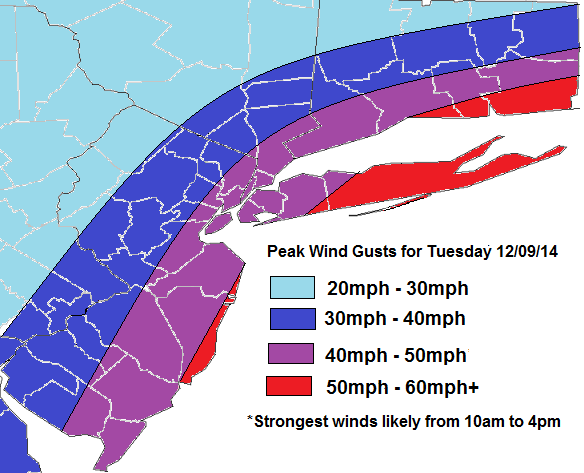
The National Weather Service out of Upton, NY has issued a high wind watch tomorrow for New York City, Long Island, Lower Westchester and Coastal Connecticut, for possibly damaging wind gusts 55mph to 60mph. The map below is what I expect for wind gusts tomorrow, over the tri-state area. This storm will track slow northward off the Mid-Atlantic coast during the day tomorrow. Then move over Long Island tomorrow evening. Ahead of a strong LLJ with winds 60kt-80kts between 850bmb (5000 ft) and 925mb (2500 ft) will be push into region late tomorrow morning and afternoon. Inversion at this level will keep much of this winds mixing down. However models show 40kt-60kt (45mph-70mph) winds (highest farther south and east) with a mixed-layer around 975mb (1500ft). Bands of heavy rain will also help bring these winds down. These winds gradually weaken across the area late tomorrow afternoon and evening, as the storm starts to occlude and weaken. Rain will continue more intermittent at times tomorrow night. Some parts of the Interior could see some snow and ice tomorrow night and it turns colder. More updates on rain/wintry impacts will be coming later today.