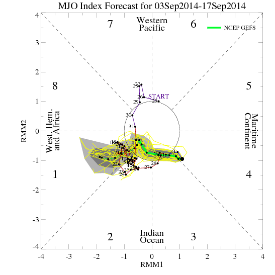
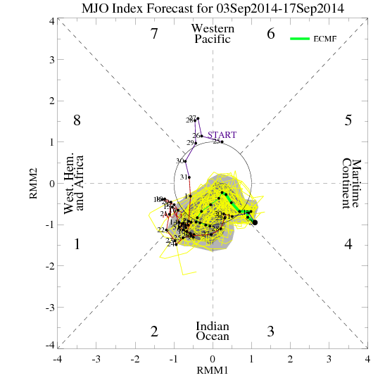
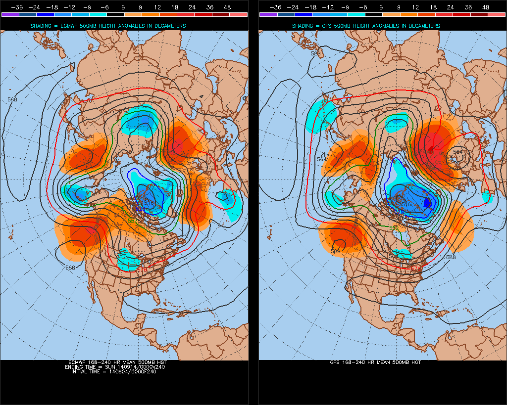
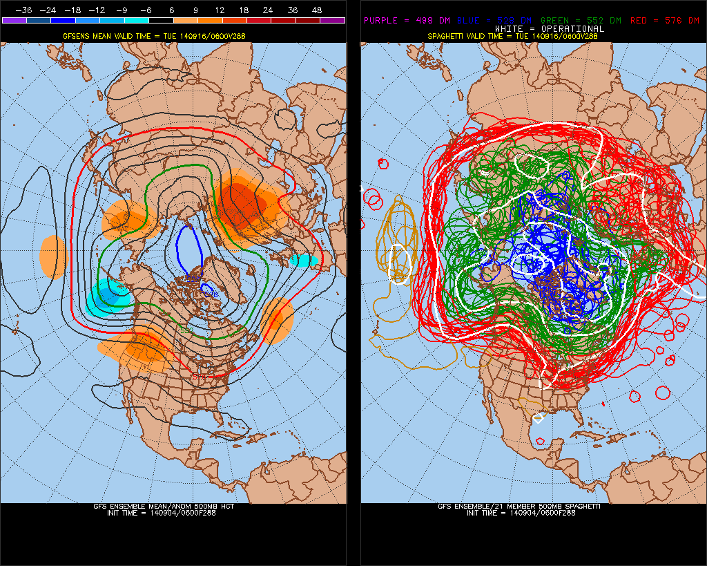
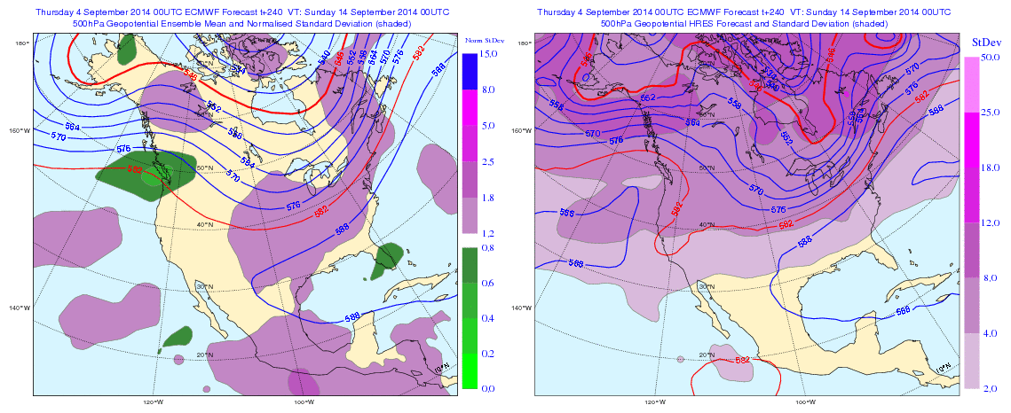
Currently the guidance has an incoherent or erratic MJO, next the 15 days or so. This has an influence on model and ensemble long-range 500mb forecasts for North America. We’ve see go back and forth between a strong ridge over the United States to not deeper trough. Until the MJO signal becomes more coherent or weakens to point where there will be little influence, we continue to see alot of volatility on guidance:
Overnight guidance looks unsettled next week, with a couple a waves of low pressure over the Mid-Atlantic states. If correct, this will have an influence on temperatures next week. Otherwise temperatures will start out near to slight below normal next week. Then trend above average later next week. Whether we same type of heat or large positive departures, we saw this week, remains to be seen. Long guidance overnight seems to be more pronounced with the trough over North America. But the GFS and it ensembles still faster bring the trough to the east than the Euro and it’s ensembles overall. The Euro still holds on to WAR and well above average for day or two before trough and cold front arrives Sept 13-14th. Their might be some GFS trough and Euro ridge bias at play here. So I’d be careful picking one guidance over the other right now, and look for consistency, trends first:
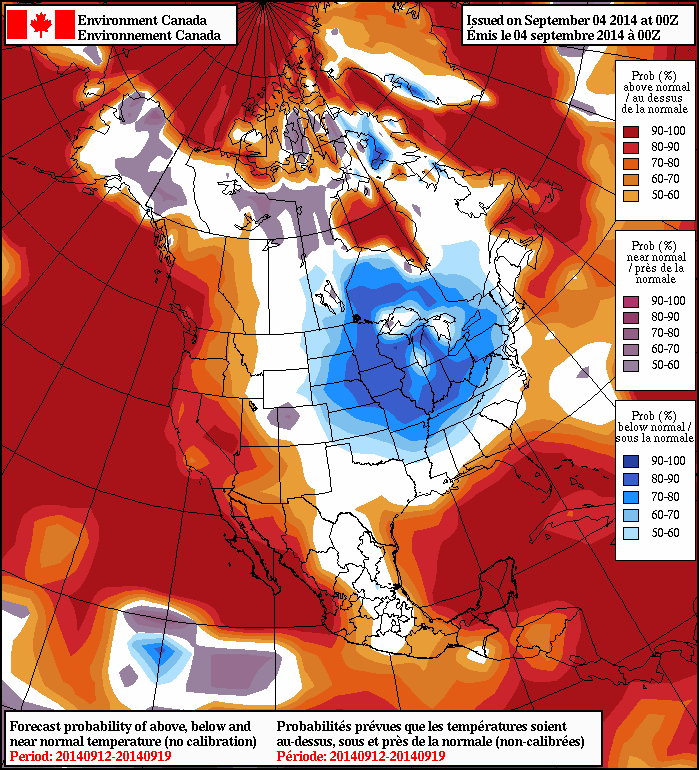
The NAFES 8 to 14 day outlooks shows high probabilities of below normal temperatures over Midwest, Great Lakes and Ohio Valley Lower probabilities for below normal temperatures further east. Probably due to strong Western Atlantic ridge keep cooler anomalies to the west. At this time, for the local tri-state area, I’m leaning towards temperatures fluctuating between slightly below normal to well above average and precipitation near normal, for the next 15 days at least. More updates this discussion may over the next couple days as more data comes in:
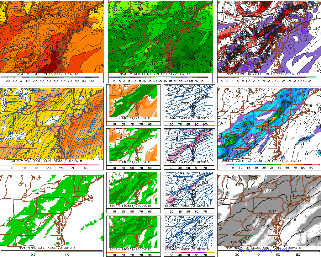
A deep southwesterly flow, will transport a very warm and humid airmass today with clouds mixing with some sunshine. High temperatures today will depend on the amount of cloud cover. Areas that see more sunshine, could get make run at 90 degrees or higher today. More clouds than sun, highs will be in lower to middle 80s. The forecast highs will compromise between middle to upper 80s. Except near the shore, a southerly winds likely keep high temperatures in lower to middle 80s. A surface trough and shortwave trough (upper-level disturbance) will trigger numerous showers and thunderstorms across the region late this afternoon and tonight.
6z NAM model showing a surface temps middle to upper 80s this afternoon in most areas with dews in upper 60s and lower 70s , Also a shortwave trough approaching trigging showers and thunderstorms over Western parts of region late this afternoon.
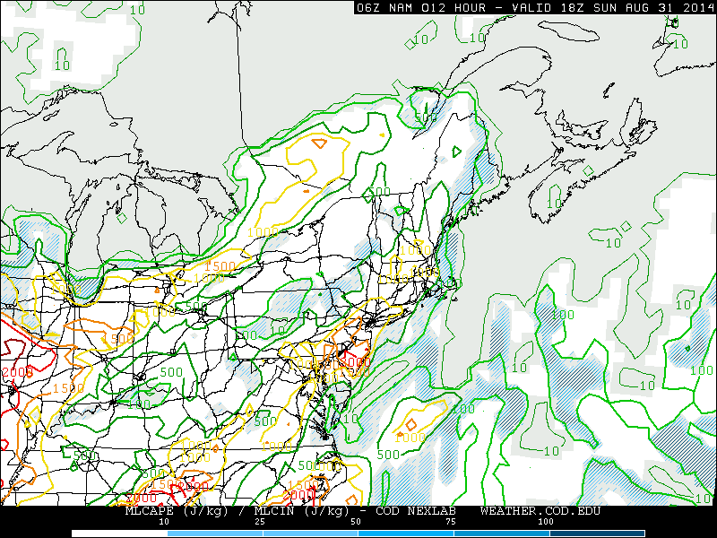
Models show anywhere between 1000 J/kG and 2000 J/kg of MLCAPE with 25kt to 35kts of shear this afternoon and early this evening. This will support some thunderstorms to become strong to severe with damaging winds being the main threat. Some backing of the low-level winds this afternoon, could support an isolated, weak tornado. Especially over Northern NJ and Lower Hudson Valley. Some hail is also possible out thunderstorms. But threat for large hail is reduced somewhat with high freezing and wet-bulb zero levels. Inhibiting factors for severe weather today, are weak mid-level lapse rates and some cloud cover keeping surface-based instability from reaching extremely high levels. Also with winds more out the south this afternoon, areas near the coast will be more stable and this may cause thunderstorms to weaken. Which is why the Storm Prediction Center has the 15% slight risk northwest of NYC. Overall I’m expecting any severe weather reports to be isolated to scattered across to the region.
6z NAM model showing MLCAPE between 1000 J/kg and 2000 J/kg by early this afternoon over the Tri-State area.
More likely than the severe weather, is potential for heavy rainfall out of thunderstorms late this afternoon and tonight with pwats (precipitable water values) near or over 2.00″. With mostly unidirectional shear, some of training of storms with flash flooding possible in low-lying or poor drainage areas. Depending how showers and thunderstorms setup some places could receive less than .50″ rainfall to locally one to three inches of rain.
6z NAM showing (pwats) precipitate water values 2.00″ over greater over the Tri-state area
That all being said, it is not necessary to cancel plans. It will be dry, until late this afternoon for most areas and perhaps until early this evening for coastal areas. If you are at beach, park,pool, etc, be prepared to move indoor as quickly as possible, if a thunderstorm hits. Any thunderstorm whether severe or not, can produce dangerous cloud to ground lightning. Don’t take shelter under trees, as they are huge conductors of electricity. Tomorrow (Labor Day) will continue very warm and humid with mixture of sunshine and clouds. More scattered showers and thunderstorm will still be threat all day tomorrow. As the shortwave trough lingers over the area. Pwats still over 2.00″ will support heavy rainfall out of any thunderstorm tomorrow. However, with move convective debris or clouds, this will likely keep instability lower. On Tuesday, surface high pressure will build briefly more sunshine. A deep southwesterly flow with 850mb temperatures around 18C will help temperatures rise into the lower 90s, away from the coast. A cold front and upper-level trough approaching from the west will trigger more showers and thunderstorms by Tuesday night.
Check the latest Tri-State 7-day forecast details and summary for more updates for today’s severe threat threat.
Also follow @WeathergunNY for any watches and warnings later this afternoon and night.
Some heat is making comeback this week, as ridge builds over the Eastern US. This ridge has been enhanced by Cristobal. Which is now a category 1 hurricane just northwest of the Bahamas and will recurve out to sea this week. Today we saw sunny skies with highs in the middle to upper 80s through much of the local tri-state area. Tomorrow looks pretty same, except a stronger south to southwest flow may keep areas near the shore a little cooler tomorrow.
On Wednesday a cold front will be across the region, during the afternoon. The flow will turn more west to southwest, pumping in more heat and humidity. Temperatures with enough sunshine could get to or above 90F degress for highs on Wednesday for much of NJ and NYC area. Some showers and thunderstorms may form along this cold front. The NAM shows very unstable airmass away from the coast, with MLCAPE values between 1500 J/kg and 2500 J/kg. Shear is also marginal enough for threat of some isolated strong to severe thunderstorms. Other models such as GFS and ECMWF have the atmosphere more capped and stable, keep coverage of showers and thunderstorm very low. It should become clearer tomorrow if we are looking at threat of severe weather.
After this cold passes through Wednesday night, a cooler less humid airmass will be ushered in again. Higher temperatures return to near normal, in the lower 80s for most spots. Heat and humidity may try to return over the Labor Day weekend. As a ridge starting building east again. However, a frontal system approaching the west, may keep unsettled weather conditions for the weekend. At this time, it doesn’t look a like complete washout, and I don’t advise to change any plans yet. But there will probably be some showers or thunderstorms, at some point. Model guidance shows different timing of this system’s warm and cold front moving through the area. This should become clearer as we draw closer.