Record Rainfall for Islip, New York 8/13/14

09/3/14 Update: An official report on this event was done by the National Weather Service in Upton,NY. It includes 1.08″ of rainfall that was recorded in just 9 minutes! The moist nature of airmass that was being transported over Long Island was extremely anomalous as well. Precipitable water values 2.38″ from climatology data was reported over Wallops,VA, Since 1963, 99% of precipitate water values were below this value. My original report:

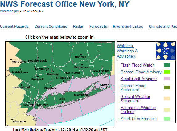
Very heavy showers and thunderstorms drenched parts of LI  overnight Tuesday and early Wednesday morning. Islip MacArthur Airport, NY received 13.27 inches of rainfall by time it was over. Another thunderstorm later in the afternoon dropped another .30″ of rainfall. For total rainfall of 13.57″ out of this event. That total breaks the all-time record rainfall in 24 hours in New York State. Which was 11.60 inches in Tannersville, NY on Aug. 28-29 2011, during hurricane/tropical storm Irene. For records at Islip Airport, 13.51″ of rain was recorded for August 13th. Which far, far exceeded the record highest rainfall for the date of 0.91″. A rainfall total of 14.03″ for the month so far, also beats the wettest August on record 13.78″ back on August 1990. It’s also very close to the all-time monthly record of 14.07 back in October 2005. The historic nature of these records are tempered somewhat by records only going back to 1984 here. However, at Central Park, which records go back to 1869, only three months have been wetter than at Islip for the month so far. Some other towns not too far away saw double-digit rainfall totals as well. Such as Holbrook with 12.57″ and Bay Shore at 11.35″. More heavy rainfall totals can be found on National Weather Service Upton,NY Public Information Statement.

National Weather Service from Upton,NY Dual Pol radar estimates up more than 10" over SW Nassau and NW Suffolk Counties
National Weather Service from Upton,NY Dual Pol radar estimates up more than 10″ over SW Nassau County and NW Suffolk County

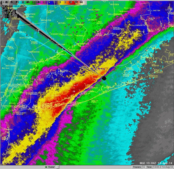
The most extraordinary note about Islip’s rainfall yesterday, was how much rainfall fell in a very short period. Islip between 5am and 7am, reported 5.34″ in first hour, then 4.37″ in the second hour. For a total of 9.71″ in just 2 hours alone! Rainfall rates like that are very uncommon for this area and more typically seen in tropical cyclones. At this time, I can’t find any information on record rainfall rates for this region. Nor can I recall any storm producing that 4″ to 6″ per hour rainfall rates. This produced a significant amount of flash flooding on roadways and neighborhoods in that area.

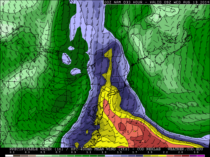
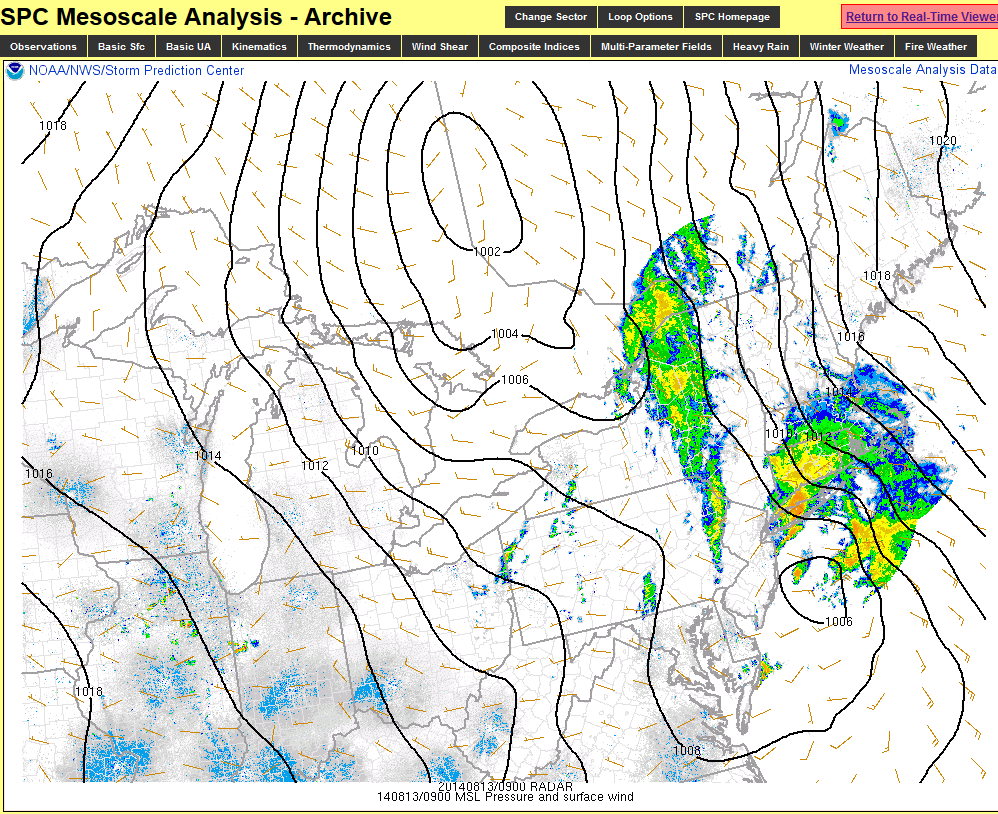
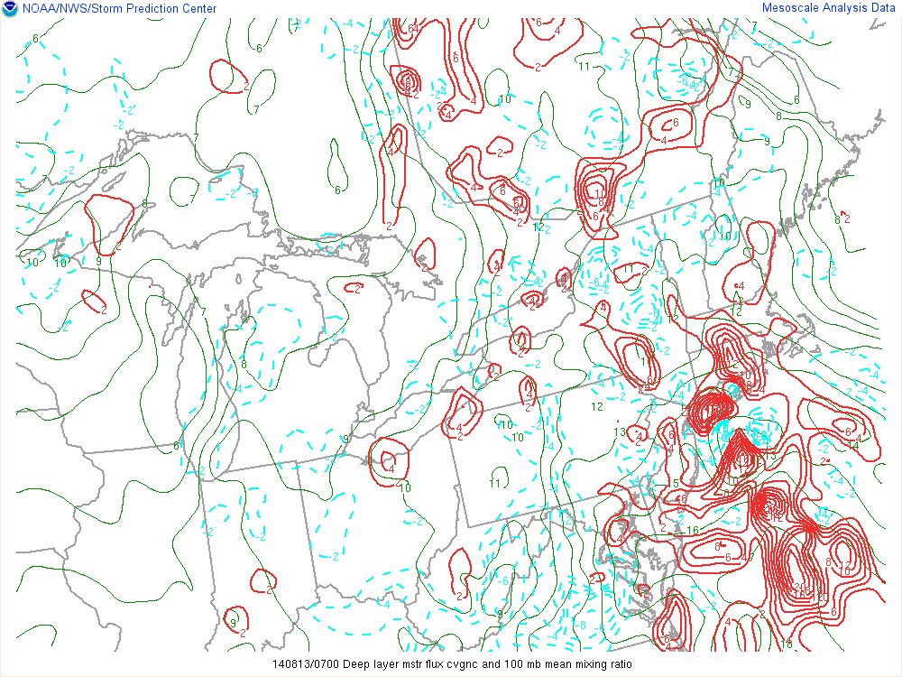
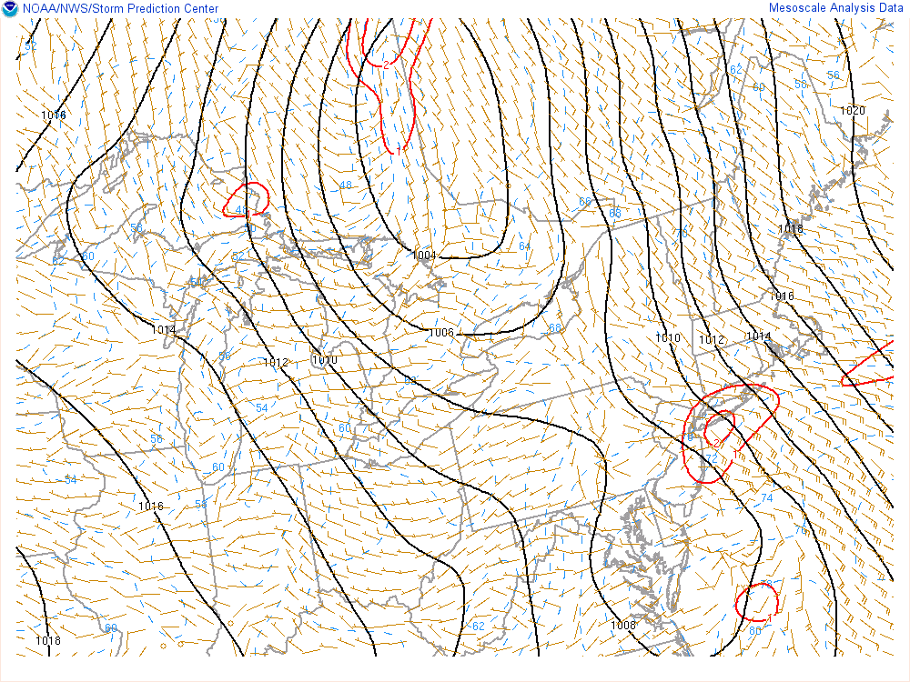
There was also a very wide range of rainfall totals across the Tri-State area. More than I originally expected myself. Most prolific rainfall totals, where just along and north of a coastal front that extended from a secondary and triple-point surface low further down the coast into Eastern Long Island. Along and just north this front, deep moist convergence and surface frontogenesis was most enhanced. A middle to upper disturbance juxtaposed with this surface system, also enhanced divergence aloft. Precipitable water values were near 2.00″ and MUCAPE near 500 J/kg. This is resulted in thunderstorms with extreme heavy rainfall rates training over from Southern NJ to West-Central Long Island. Winds were also gusting over 40mph near the shores as well. Highest report was a 57mph thunderstorm wind gust near Robert Moses State Park in Long Island.

SPC mesoanalysis showing the primarily low over Canada. Secondary low east of NJ causing heavy thunderstorms over Long Island early Wednesday morning.
SPC Mesoanalysis showing deep moist convergence early Tuesday morning over Central LI.
SPC Mesoanalysis showing deep moist convergence and 100mb mixing ratio early Tuesday morning over  West-Central Long Island.
SPC Meso
SPC Mesoanalysis showing surface frontogenesis highest over Central Long Island

With an extreme amount of dynamics focused over these regions, this took alot of energy for heavy rainfall for areas farther inland and further east. Which resulted in far less rainfall. While in my last post, I mentioned there could be localized higher totals with any training t-storms anywhere, I didn’t discuss the possibility that the secondary/triple-point low could rob areas further inland of moisture and dynamics. Most model guidance didn’t not these handle these apsects as well. Therefore the rainfall totals shown on the models where far off for most areas. But that it is not really unusual. It’s always difficult for the models, resolve differences in convective parameters and forcing mechanisms. When accessing heavy rainfall potential, it’s better look for and focus more on synoptic features present on the models. Such as the low-level jet and precipitable water values. That all being considered, I don’t think anyone could of reasonably argued for more than 10 of rain for parts of the area, from a non-tropical system that was relatively progressive for our area.

Heavy Rain & Thunderstorms Coming Tonight

An upper-level trough center over the Great Lakes will be taking a negative tilt today and tomorrow. At the surface, a low moving northward into Great Lakes,  will push a warm front will slowly across the Northeast. Rain over Pennsylvania this morning is well ahead of the this warm front and will likely break up somewhat as it comes east into stronger high pressure. But some intermittent rain or scattered showers are still possible during today, for the entire Tri-state area.

Tonight and tomorrow morning, things get more interesting. The upper-level trough takes a negative-tilt and a secondary area of low pressure develops along the warm front. This will lead to stronger southeast flow, pumping a copious amount of moisture from the Atlantic into the tri-state area. Precipitate water values will increase to 2.00″ or higher. Lifting along warm front will be enhanced by two divergent upper-level jet streaks, a strengthening low-level jet and increasing convergence with secondary low acting as a triple-point. Elevated instability will be on the increase MUCAPES are forecast to be between 500 J/kg to 1000 J/kg, early tomorrow morning. This will result area of heavy rain and embedded thunderstorms moving across the area.

The 0z NAM showing precipitable water values near 2.00" or higher late tonight with the deep southerly flow.
The 0z NAM showing precipitable water values near 2.00″ or higher late tonight with the deep southerly flow.

Rainfall totals of at least 1 to  2 inches are likely for many areas. Some locally higher totals are possible, where thunderstorms train. Orographic lifting with the southeast flow may also aid areas inland areas receive between 2 to  4 inches of rainfall. For those reasons, the National Weather Service have issued Flash Flood Watches for parts of the region. Heavy rain could fall in a short period of time, resulting in flooding on roadways, poor drainage and low-lying areas.  Flooding near small streams and rivers is also possible.

Flash Flood Watches in Green by the National Weather Service
Flash Flood Watches in issued by the National Weather Service

At this time, severe thunderstorms are not anticipated. There will be 30-40kts of 0-6km  shear. Helicity values will increase to near 500  m2/s2.  Lifting condensation levels will also be low. But with the secondary/triple-point low tracking mostly south and east of the area, during the early morning hours, low-level instability looks marginal at best. The threat for thunderstorms to produce a damaging wind gust or a weak tornado, appears to be extremely low and isolated in the Tri-state area. This threat will increase somewhat as head further south and west in Mid-Atlantic region, where instability could be higher.

Heavy rain and thunderstorms should taper to scattered lighter showers during the midday hours tomorrow, as the lifting with the warm front shifts north and east. There is chance clouds break for sunshine in parts of the area, by late tomorrow afternoon. Thursday and Friday are looking dry and with temperatures in the upper 70s or lower 80s. Which is slightly below normal for this time of year. However, a warming trend should be this weekend, with a southwest flow sending high temperatures pushing into lower to middle 80s.

Hurricanes Iselle and Julio Threaten Hawaii

Usually we are talking hurricanes in the Atlantic. Since there are often a threat to the US mainland. But our long-distance have two hurricanes two hurricanes be concerned about in East Pacific. The first is named Iselle. The second behind it is named Julio.

Image courtesy of NOAA

Hurricane Iselle has a triggered the first hurricane warning, in many years for Hawaii. As of 11am HST, Iselle is about 625 miles east-southeast of Kilo, Hawaii, on the biggest island and is moving west-northwest at 16mph. Maximum sustained winds are 90mph. Often hurricanes coming from the west weaken due to cooler waters and high shear environment closer to Hawaii Islands. However, Iselle as actually done the opposite today as shear remains light over it. Some weakening down to a tropical still expected as Iselle get closer to Hawaii. But out of caution, the Central Pacific Hurricane Center has a hurricane warning, for the biggest island. Their forecast track takes the center right over the island.

11HST forecast from the Central Pacific Hurricane Center
11am HST forecast from the Central Pacific Hurricane Center

As of 2pm PDT, Julio is minimal hurricane with winds at 75mph. Current forecast Julio’s center moving north of Hawaii. Julio could be a threat in about 3-4 days. The track of Julio will dependent on how much of weakness in the ridge there will be north of Hawaiian Islands. A stronger ridge will force a track further south over Hawaiian Islands, as few tropical models show. But a many more are clustered with a track well north islands.

aep10_2014080618_track_earlyIt’s rare for hurricanes to hit Hawaii. The last hurricane to make a direct hit on Hawaiian islands was Iniki on September 11, 1992. The storm tracked south of tbe big island, where the ocean is warmer. Then it made a turn north and struck the western most island Kauai as a Category 4 hurricane with winds 135mph. It caused billions of dollars in damage and killed 6 people.