Update: As of 11am EDT, the National Hurricane Center upgrades Bertha to catergory 1 hurricane with 80mph maximum winds. No other changes from below.
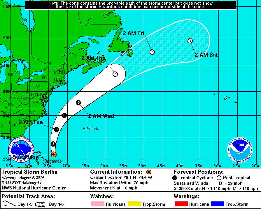
Tropical Storm Bertha became better organized and stronger overnight as shear decreased enough for more thunderstorms to wrap around it’s now closed surface center. According to the National Hurricane Center, maximum sustained winds have increased to 70mph and the central minimum pressure has fallen to 999mb. Bertha is now over very warm water and in an environment with less shear and dry air impeding further development. So it is likely to become a category 1 hurricane sometime today or tonight.
Bertha has also turned north and will gradually turn to the northeast into the open Atlantic, ahead of upper-level trough over the Eastern US. As the model consensus has been showing for days. The only impact from Bertha in tri-state area will likely be some high surf and rip currents along the shores as it makes it closest approach to our area sometime between Tuesday and Wednesday. Then Bertha is expected to weaken and become a non-tropical system as it moves into the cooler waters of the North Atlantic, later this week.
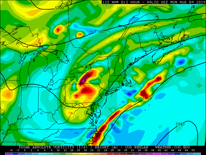
A weak wave of low pressure moving north, along a stalled frontal boundary, has been producing some showers over eastern parts of the Tri-State area this morning. This system is now moving out of the area and clouds will break for some partial sunshine this afternoon. An 500mb shortwave approaching from the west and south, may trigger some widely-scattered showers or thunderstorms late this afternoon and tonight. Particularly over Northwest New Jersey and the Lower Hudson Valley. Some heavy downpours with any thunderstorms are possible. Instability will be on the low side. So severe thunderstorms are not anticipated. Temperatures will only rise into middle to upper 70s despite some sunshine this afternoon. Which is several degrees below normal.
12z NAM showing the 500mb shortwave over PA late this afternoon
Monday and Tuesday will be partly sunny and warmer with temperatures in reaching the lower to middle 80s. With colder air aloft, there is a chance of an isolated shower or thunderstorm to pop up in the afternoon and early evening hours. Especially, north and west of New York City. Marginal instability and weak shear supports any thunderstorm be slow-moving and produce heavy rainfall. Then a series of disturbances will move across the area, from the west on Tuesday night and Wednesday. Clouds will mix some sunshine, with a chance of some scattered showers and thunderstorms, Heavy rainfall from thunderstorms is again possible. But at this time, with only marginal instability and weak winds fields being shown, severe weather is not expected. A cold front will move across the area on Wednesday night. Fair weather will return on Thursday and Friday, with high temperatures closer to 80 degrees. Which is slightly below normal for this year.
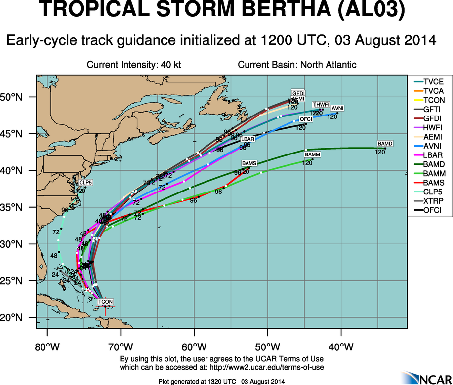
12z model projects. Strong consensus on a recurve between U.S. East Coast and Bermuda.
Meanwhile, Tropical Storm Bertha continues to churn, just north of Hispaniola and over Turks and Caicos islands this morning. Currently the storm is poorly-organized with most of the convection east of the presumed center. Surface observations available in the region this morning, also don’t indicate a closed surface circulation. However, most models continue to show Bertha becoming a strong tropical storm or minimal hurricane in the next few days as it recurves out to sea, midway in between the US East Coast and Bermuda. A few models suggest that Bertha remnants will be absorbed by a non-tropical low developing near the Southeast US Coast this week. Either way, no direct impacts are expected from a tropical system are expected in the Tri-State area. Except for perhaps some rough surf at the area beaches on Tuesday or Wednesday.
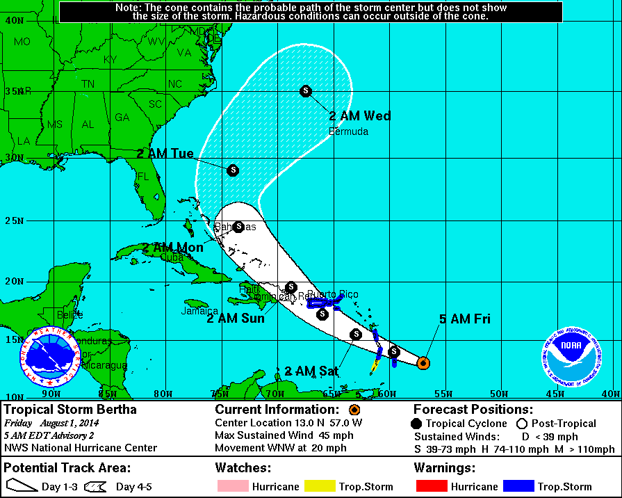
A tropical disturbance about 170 miles east of Barbados, that has been struggling with dry air this week, has developed enough convection to be upgraded to Tropical Storm Bertha. As of 5am EDT, maximum sustained winds at 45mph and it moving west-northwest at 20mph. Tropical Storm Warnings have been issued the lower Lesser Antilles and Puerto Rico and Virgin Islands. The National Hurricane Center forecasts Bertha to track northwest into Northeastern Caribbean over the next three days, as a tropical storm. Then gradually turn northeast into the open Atlantic by five days, with little change in strength.
National Hurricane Forecast from at 5am EDT Friday 8/01/14
Currently Bertha is producing intermittent bursts of convection, that being are prevented from wrapping around the center of circulation, due to strong upper-level shear. Some dry air is entrainment, is also inhibiting more persistent convection. Bertha is likely remain in in a hostile environment over the next three days, as upper-level trough continues produces strong shear Eastern Caribbean. Then Bertha is likely to interact with the mountains of Hispaniola. Therefore little change in strength is expected and it is possible that Bertha may weaken to a tropical depression or tropical wave during this period.
Current Shear Tendency from CIMSS shows 30-40kts of upper-level shear over the Eastern Caribbean Sea.
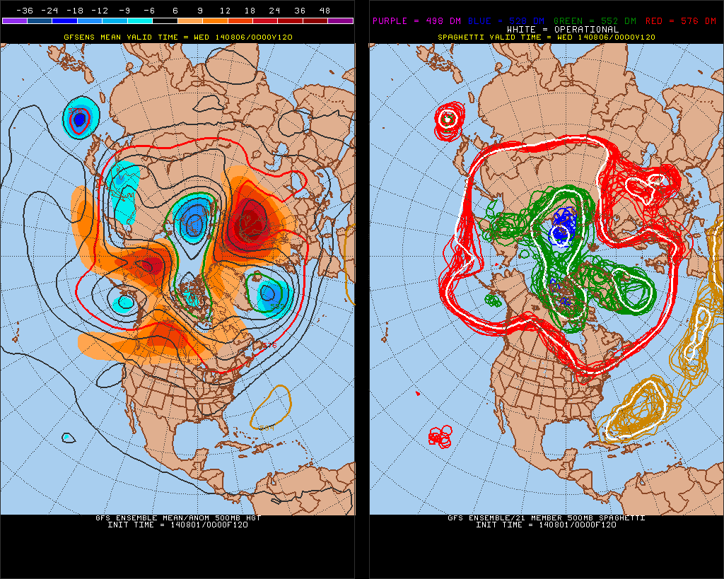
In about 3 days, what remains of Bertha will reemerge over the Bahamas. It may be under a more favorable environment for intensification. In 4-5 days it will become more underneath the influence of a trough over the Eastern United States. At this time, all of the model guidance shows this trough, forcing Bertha to recurve somewhere midway between the U.S. East Coast and Bermuda. This would spare both regions from any major impacts. The lack of high-latitude blocking or a stronger Western Atlantic Ridge, during this time frame, strongly supports this scenerio, as well.
0z 8/01/14 GFS ensemble mean 500mb forecast at 120hrs. Showing a trough over the Eastern US. No high-lattitude blocking over the Atlantic. (Image courtesy of Penn State University)
However, much of the guidance also shows Bertha becoming a strong tropical storm or minimal hurricane after 72 hours. If Bertha were to remain a weaker system, it would feel less influence from the trough and might track further south and west. While only having relatively minor impacts along the US East Coast. It’s also possible question, Bertha interacts enough with trough to produce more heavy rainfall along East coast early next week, without ever making landfall along the US East Coast. This scenarios have a low probability of occurring. But are worth continuing to monitor Berth for.
 Bertha has also turned north and will gradually turn to the northeast into the open Atlantic, ahead of upper-level trough over the Eastern US. As the model consensus has been showing for days. The only impact from Bertha in tri-state area will likely be some high surf and rip currents along the shores as it makes it closest approach to our area sometime between Tuesday and Wednesday. Then Bertha is expected to weaken and become a non-tropical system as it moves into the cooler waters of the North Atlantic, later this week.