Lobe of Polar Vortex Suppresses Winter Storm

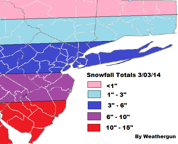
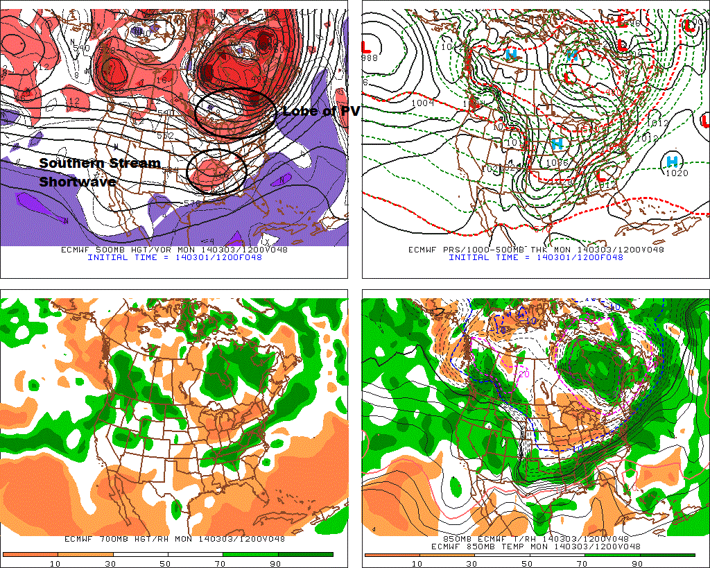
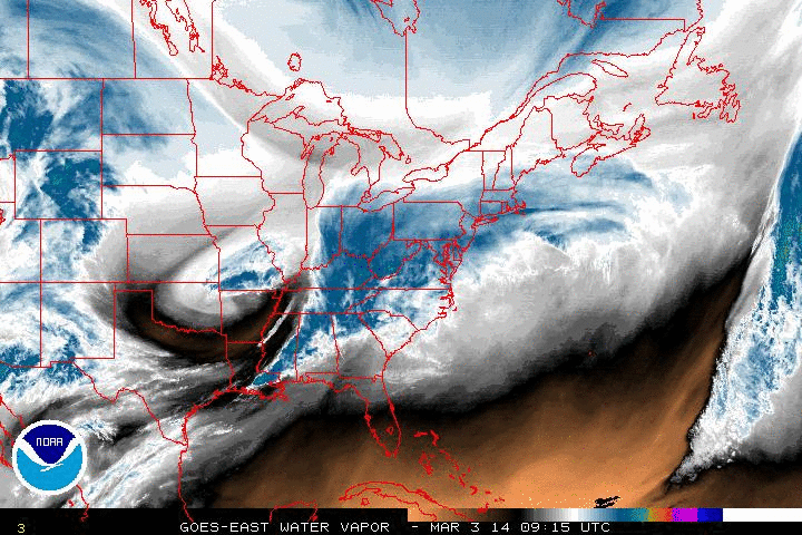
Much of tri-state area, escaped this winter without seeing a significant snowfall. Parts of NW NJ, Lower Hudson Valley and CT, saw no accumulation. The reasons for this, were discussed in last two posts, before this one. However, now you see it happening on water vapor loop this morning. The drier area dropping over the Great Lakes and Northeast, is strong confluence flow behind associated with a lobe of polar vortex. This is currently  shearing and suppressing this storm to the south and east of us.

5wv-animatedAs this happening another bitterly cold airmass coming into region. Tonight the NAM show temperatures possible dropping into single digits over NYC and NW suburbs tonight, with a northerly flow. New record lows could be set again, tomorrow morning. Especially at the airports.

New Snowfall Map for 3/02-3/03

FinalSnwofallmap0303

This morning’s 6z and 12z NAM, RGEM, GFS guidance today has trended further south this storm. The latest HRRR runs also supports this trend. Total qpf totals for Northern NYC are now in .10″ -. 25″ range. With less north and more south. Current radar, water vapor imagery, and observations, don’t give me much reason doubt these solutions. Also some warmer temperatures, may support more wet snow,sleet, rain at onset. Especially over Southern New Jersey. The cause for the continue trend further south, is the lobe of the PV, dropping down faster into Great Lakes and Northeast regions and suppressing this
southern stream wave.

Along with the south trend, is also a trend to end the storm faster everyone. For NNJ,NYC, LI snow may tapering off to flurries by sunrise tomorrow morning. While steadier snow continues further south into late morning or early afternoon hours tomorrow.

So for all those reasons, snowfall totals have been adjusted downward everywhere. And it’s possible this is still too high for some areas. Just to note, the ranges in general, are from lowest to highest; from north to south. For example: Staten Island, is more likely to see 3″ or 4″ than 5″ or 6″. While Philadelphia is likely to see at or either side close to 6″.

Snowfall Map for Winter Storm Sunday Night and Monday


FirstSnowfallmap0303Latest guidance over the past couple days has trended farther south with this storm for Sunday and Monday. Models now show stronger confluence, behind a lobe of the polar vortex, swinging over the Great Lakes. This is shearing and suppressing the southern stream disturbance to the south and creating a sharp cut-off of northern fringe of area of overrunning precipitation with this system. There will be heavier banding just north of the thermal gradient. Where it stronger frontogenesis will be occurring. Which currently appears to be over Southern New Jersey and DE and SE PA.

12zECf48The NAM is also slowest push the artic boundary to the south of the area tomorrow. So there may be some light rain,sleet, and/or wet snow at the onset. Especially for the coastal sections. But this should quickly changeover to snow tomorrow night. With surface temperatures falling through the 20s and teens. Liquid totals are expected between .25″ to .50″ over NYC/LI/NNJ. Less to north. As much as 1″ of liquid in SNJ. The column with warmer air aloft, support snow ratios to average between 12 and 15 to 1 for much the area. Strong upward vertical motion by might support higher ratios south of NYC.

Check back for more updates. If they are any changes handling the lobe of the polar vortex or the southern stream disturbance, there could be some north or south adjustment to snowfall totals tonight or tomorrow.