Hurricane Odile Slams into Baja California, Edouard Almost A Major Hurricane

Check out previous posts on Odile and Edouard over the weekend at Tropics.

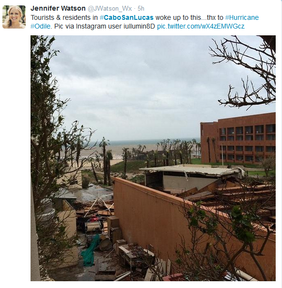
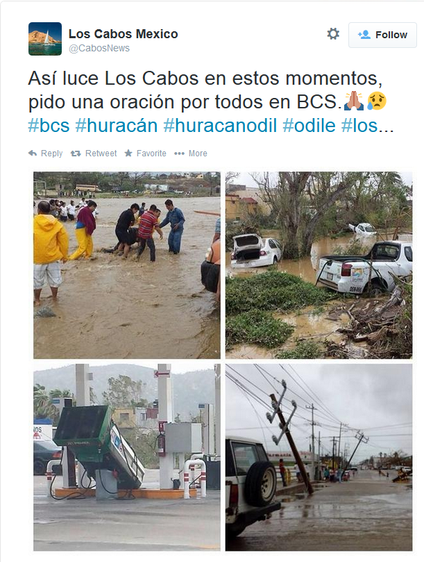
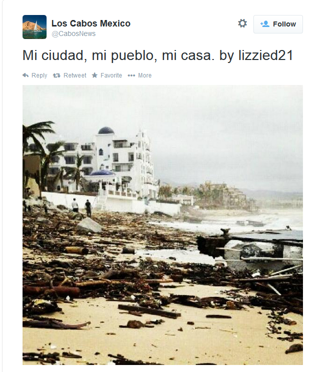
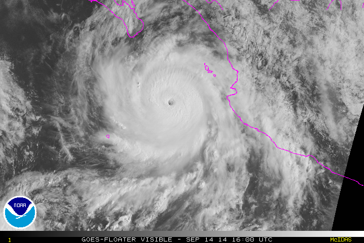
Odile made landfall near Cabo San Lucas, MX as major category 3 hurricane with maximum sustained winds at 125mph at about 925pm PDT. An automated station on Cabo San Lucas reported a sustained wind at 89mph and  a 116mph gust, near the time of landfall. Odile has significantly weakened today, while moving inland over Baja California. Maximum sustained winds are now 80mph, as of the 5pm advisory from the National Hurricane Center today. Odile is the strongest hurricane to make a direct hit on the Cabo San Lucas area, and from images today,  appears it had devastated parts of the area. Some major damage has been reported. Just give you an idea of magnitude of this storm, below are some rainbow animated loops of Odile just before and after making landfall and some pictures of devastation from people in the area.

 rbtop-animated2

CaboSanLucasdamage1Damage2Damage3
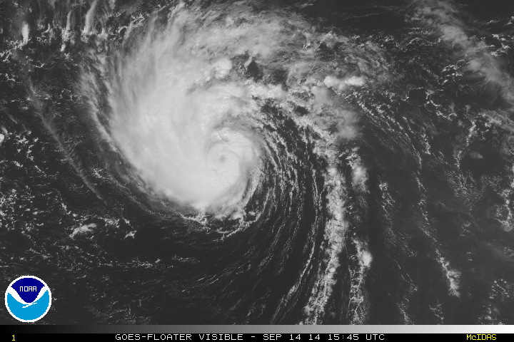
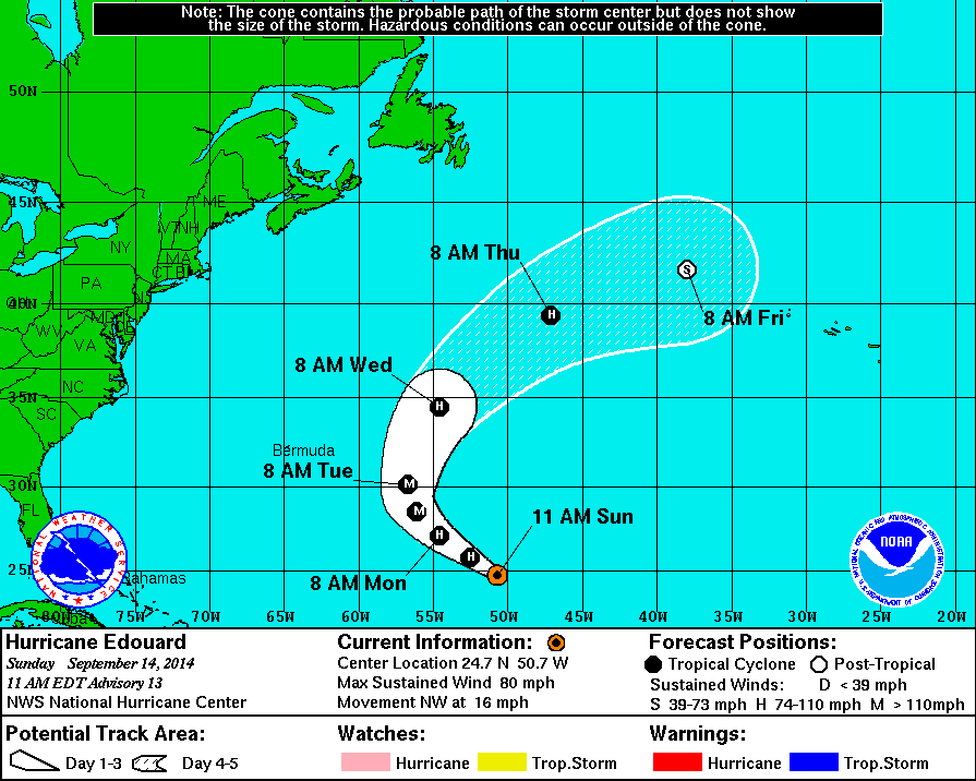
Odile is likely weaken to remnant low, over next couple days. A trough moving California may carry Odile’s remnants into Southwest US, later this week. Meanwhile Hurricane Edouard, is still going well out in the Atlantic (as shown below) it is almost category 3 hurricane with maximum sustained winds at 110mph, as of the 5pm advisory from the National Hurricane Center. Satellite image shows an a large eye has cleared out and is surrounded by ring of deep convection. This is a good sign of hurricane intensifying and Edouard will likely become a category 3 later tonight. Edouard still expected recurve into North Atlantic. However a wave model shows some 3 to 4 feet swells impacting the East Coast on Wednesday.

rbtop-animated

Major Hurricane Odile Threatens Baja California, Hurricane Edouard No Threat to Land

9/15 7:00am EDT Update: Odile made landfall near Cabo San Lucas, Mexico as major category 3 hurricane with maximum sustained winds at 125mph at about 925pm PDT overnight. An automated station on Cabo San Lucas reported a sustained wind at 89mph anda gust 116mph. As of the 5am Advisory, Odile is still moving north-northwest over the Baja California and has winds of 115mph. It will continue to weaken today over land. Edouard is now a category 2 hurricane with winds at 105mph. Edouard is likely to become the first major Atlantic hurricane of the season and remains no threat to land.

This post is update to previous post overnight on these storms:

Odile continued to rapidly intensify overnight. It’s now major category 4 hurricane with maximum sustained winds at 135mph and is moving northwest at 14mph. It continues to be a threat to Baja California.  The storm appears to now have a double eyewall and will likely go under an eyewall replacement cycle soon.  Little in change in strength over next 24 to 36 hours, as comes very close to southern tip of Baja California. An aircraft reconnaissance is on route to the storm and should have a better assessment on the intensity. Hurricane warnings now stretch further to Punta Abreojos on the west coast of Baja California. Odile is expect to rapidly weaken, once it moves over cooler sea-surface temperatures off the central west coast of Baja California:

 vis0
145811W5_NL_sm

Edouard has become a category 1 hurricane in the Central Atlantic. The fourth hurricane of the Atlantic hurricane season. Maximum sustained winds are 80mph and it currently moving to the northwest at 14mph. An eye has become more visible in satellite imagery, over the past several hours. Edouard is now forecast to become a major category 3 hurricane. But it will remain no threat to any land. A large, deep trough over Eastern US and Western Atlantic will force Edouard to turn to north than northeast this week:

vis0

145744W5_NL_sm

Rest of the tropical Atlantic looks quiet right now. Some medium to long-range models show tropical systems developing in the Caribbean or the Atlantic. However these models have low reliability, at this range and solutions could vary from run to run. People need to use extreme caution, using these model forecasts.

Auroras Brighten the Northern Skies

On Wednesday, Sept. 10th the sun released a X class solar flare. This reached the earth and caused auroras (otherwise known as northern lights), over parts of Northern Hemisphere over past few nights. These are some spectacular and beautiful pictures from observers that were tweeted from Observing Space from Friday night:

Mt. Washington Observatory in New Hampshire. Credit: Ryan Knapp
Mt. Washington Observatory in New Hampshire. Photo Credit: Ryan Knapp
Burntcoat, Nova Scotia.  Photo Credit: Tim Lingley
Quebec, Canada. Photo Credit: Patric Nadeu
Burncoat, Nova Scotia. Photo Credit: Tim Lingley