Tropical Update 9/14/14: Edouard Out to Sea, Hurricane Odile Threatens Baja California

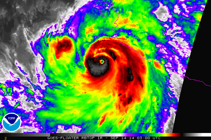
8:35am 9/14 Update: Odile is now major Cat 4 hurricane with 135mph winds. Another post coming later today.

Just another update on the tropics both in the Atlantic and East Pacific

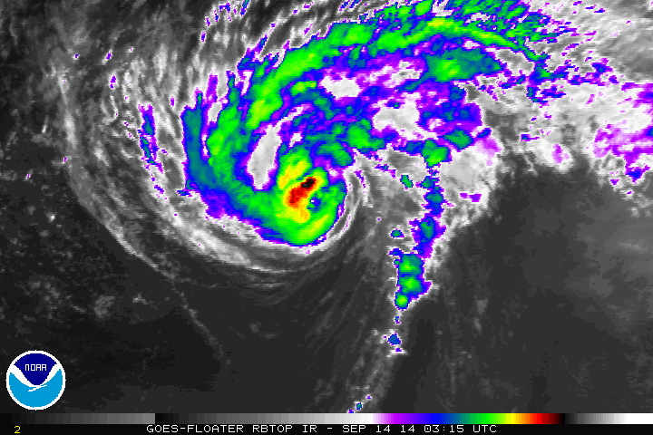
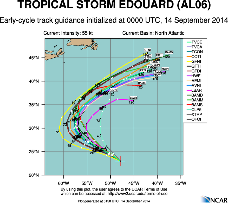
Tropical Storm Edouard is about 1000 miles east-northeast of the Leeward Islands. Edouard has intensified with current maximum sustained winds at 65mph and has turned to the northwest at 14mph. All model guidance continues show to Edouard recurving into open North Atlantic over next 4 to 5 days. Perhaps becoming a Category 2 or 3 hurricane, as it continues to move over warm sea-surface temperatures and more favorable upper-level environment.

rbtop0

aal06_2014091400_track_early

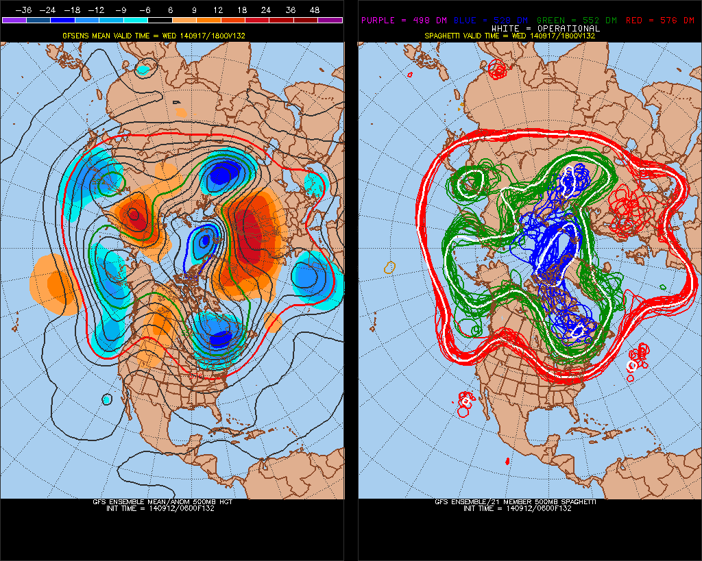
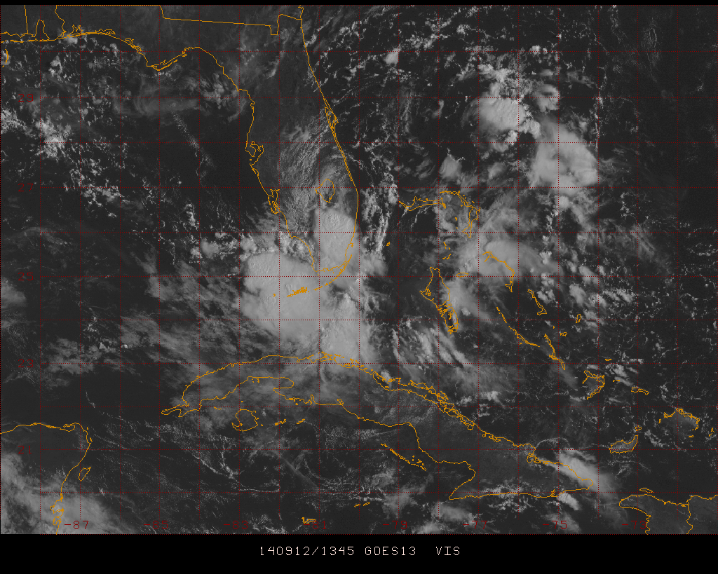
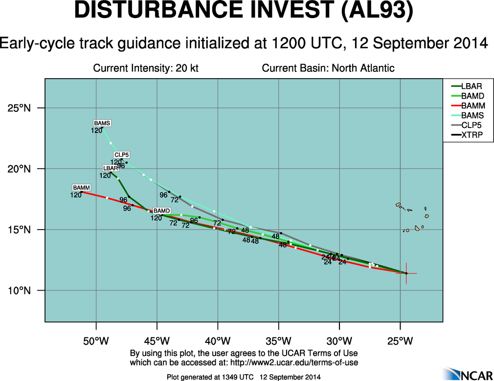
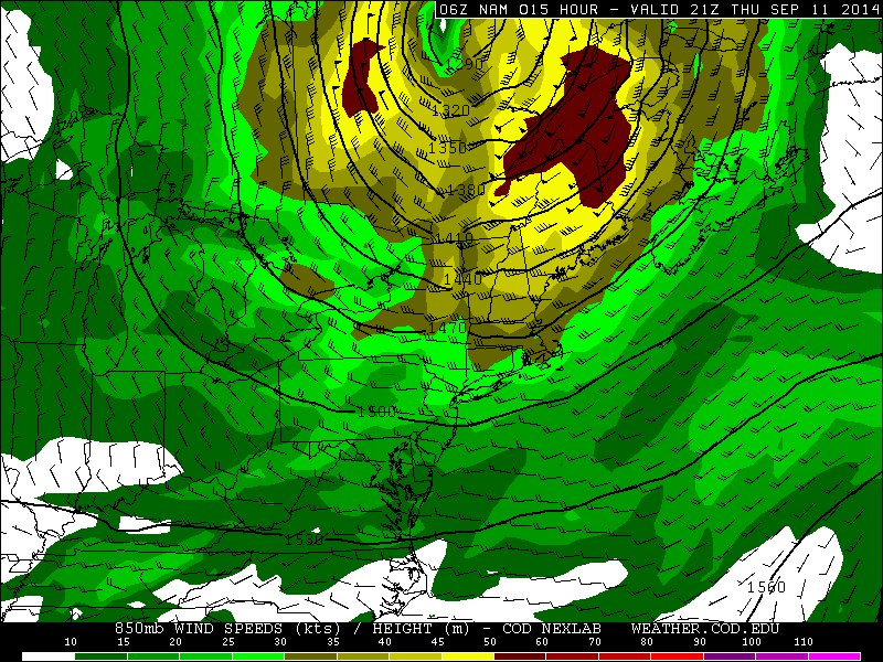
Invest 92L is now the Gulf of Mexico. But has become less organized with low-level center less defined and lack of convection. Strong northeasterly wind shear and dry air intrusion is now expected to prevent further development of this disturbance.Convection has diminished with Invest 93L in the East Atlantic. Dry, sinking air around this disturbance, is now likely to prevent further development.

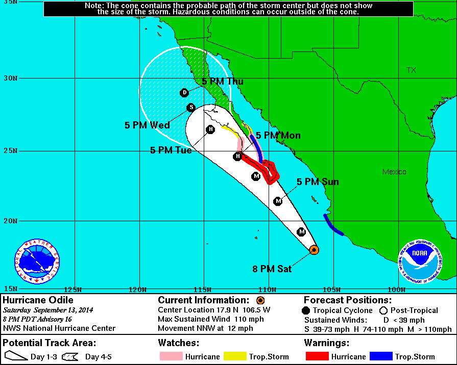
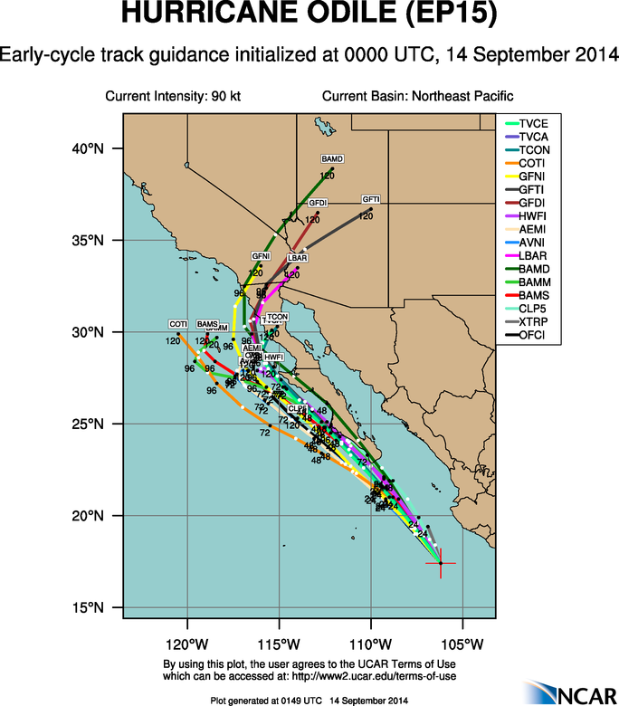
Without any threats in Atlantic, our attention turns to East Pacific again. Hurricane Odile is rapidly strengthening and is now a major threat to Baja California. As of the 8pm PDT advisory from the National Hurricane Center, Odile is moving to north-northwest at 12mph with maximum sustained winds at 110mph. Making a strong catergory 2 hurricane. It’s is forecast to become a major category 3 hurricane and track very close to the west of southern Baja California, late on Sunday and Monday. Hurricane warnings have issued for the region, including Cabo San Lucas. It is possible Odile could become even stronger and track even further north and east over the southern Baja Peninsula. After Monday, Odile is expected continue to track north-northwest just west over the central Baja California and gradually weaken to a tropical depression as it moves over cooler waters. Some model guidance also take remnants of Odile into parts of Northern Baja Peninsula and the Southwest US later next week. All interests in the Baja Pennisula should keep an eye on Odile this week. People in the hurricane warned and watched areas should take immediate precautions.

rbtop0

8pm PDT Track

aep15_2014091400_track_early

Tropical Update: Edouard & Invests 92L & 93L

Hurricane Season has relatively quiet so far. The main reason are that the subtropical high has been stronger parts of Central and Eastern Atlantic this year. This causes stronger easterly shear and more dust off Africa . Which inhibits more developing tropical waves moving Africa coast. Stronger high over East Atlantic, also  allow more troughs or upper-level lows persist over Western Atlantic. Which cause more shear and dry air or tropical systems to recurve out to sea. This pattern continues as watch a few new systems in the Atlantic basin.

This morning visible Image of Tropical Storm Edouard from PSU Ewall

Tropical Storm Edouard (as seen above) has formed in Central Atlantic. As of the 5am ET advisory from the National Hurricane Center, Edouard is about 1325 miles east of Leeward Islands and moving west-northwest at 15mph. Maximum sustained winds are at 45mph. Currently the storm is encountering some moderate southwesterly shear. Which is restricting outflow on the western side. Slow strengthening still is expected over the next 5 days and it could become a hurricane. However it will pose no threat to land / All models are agreement that Edouard will turn north then northeast, between 50W and 60W.  As deep trough moves into Eastern US and Western Atlantic early next week.

6z GFS ensemble mean from PSU ewall
6z GFS ensemble mean showing a West Coast Ridge producing a large, deep trough over eastern US and Western Atlantic from PSU ewall

Another area of interest this morning, is a tropical disturbance labeled Invest 92L. Which is moving over Florida. Land interaction and some strong southwesterly shear now will inhibit further development until it moves over Gulf Mexico later tonight or tomorrow. The models eventually take 92L westward into Western or Central Gulf of Mexico over next 3-5 days. Upper-level winds on the models look favorable some slow development into a tropical depression or  tropical storm. So areas along Western and Central Gulf coast should keep an eye on this disturbance.

Visible of nvest 93L over Florida form PSU Ewall

A tropical wave in Cape Verde has shown some signs of organization and been labeled as Invest 93L this morning. It’s too soon to say what the fate of this wave will be, with much confidence. But first generally have it tracking to west to northwest, over  the next five days. Posing no threat to land.

aal93_2014091212_track_early

Why Models Show Less T-Storms Late Today

If you are looking the qpf or simulated radar models this morning, you will notice the lack of t-storms today for the tri-state area. There a number of reasons why. First the NAM (as well as other models)show the core of 700-850mb jet streak over Northern parts of New England. On the left-rear side are westerly winds causing the air to dry and sink at the level, over the tri-state area. This will tend to suppress more thunderstorm development late this afternoon:

6znamNE_700_spd_015

6znamNE_850_spd_015

Models also show more instability, particularly CAPE over the Lower Mid-Atlantic region. Which is why the models like the NAM show more showers and thunderstorm forming along the cold front to the south of tri-state area. From experience, thunderstorm tend congregate in areas where more parameters, such as lift and instability are supportive. I still expect some showers and t-storms this afternoon. But over the tri-state area, there will be likely be more widely scattered with perhaps some isolated strong wind gusts. The chance of thunderstorms to reach severe levels are still very low. Latest guidance shows 0-6km shear increasing to 30kts to 40kts with a 50-60kt 500mb jet streak approach from north and west this afternoon. Which is not enough CAPE to support many tall or strong updrafts.  Poor lapse rates and some cloud cover and onshore winds for the coast, will likely limit the amount of the instability this afternoon. As well reduce the ability for thunderstorms to produce damaging wind gusts. Pwats are still very high over 2.00″. So any thunderstorm is still capable of produce heavy rainfall and flash flooding poor drainage areas:

6znamNE_con_sbcape_015NY.vis