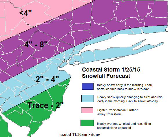
Snowfall forecast 11:30am 1/25 Update: The model guidance has trended with faster developing trough of warm of air aloft (TROWAL) and cold-conveyor belt with this storm. This means higher totals areas further Northwest. Also the cold-conveyor belt (CCB) tracks further east tomorrow over the area. For example, the 12z NAM model show below decent vertical velocities or lifting that and boundary level temperatures cooling enough for bands moderate snow late tomorrow afternoon for much of the area. Right now, I see this making for loss snowfall accumualtion with the changeover to rain in the morning for coastal areas. But I will monitor any stronger model trends with this CCB.
From last night:
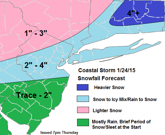
Snowfall forecast below for Saturday’s coastal storm you probably have heard about. Precipitation should arrive early Saturday morning and continue through most of the day. As with ever potential winter storm, there number things that often need to come together for a significant snowfall in the Tri-State. Especially for New York City and coastal sections. Here are some pros and cons for this storm that I see below. Based on the today’s model guidance:
Pros for snowfall
1. Surface and 850mb lows track south and east of area of the tri-state area.
2. Enough cold air already in place.
Cons for snowfall
1. No strong, cold high pressure to the north to keep cold air or setup a thermal gradient.
2. Not enough blocking in Atlantic, to force a slower moving storm
3. Phasing with northern stream occurring late.
4. Ridge more over the Pacific instead over the West Coast of North America.
Consider there are more pros and cons here. My forecast has light to moderate snowfall totals at best. Despite the low deepening into 980-990mbs, this storm matures to late for most of our area. Over interior Central and Eastern CT, this storm will start develop enough, that some heavy rates of snow may be possible. Comeback for more updates to this forecast and some model analysis tonight or tomorrow. As well an update for another threat for snow early next week!


