Snow will overspread the area from southwest to northeast later this morning and this afternoon. Latest NAM and RGEM show snow changing to sleet then freezing rain for many areas NYC and south and east this evening. However, warm air advects northward, between 850-925mb, the thermal gradient will be increasing at this level. This could enhance lifting for a period of moderate to heavy snow before this changeover occursover North-Central NJ, New York City and Long Island. If this changeover before 7pm,then 2″ or 3″ is more likely to occur. If the changeover is delayed just an hour or two 4″ or 5″ are more likely. This even more likely over north shore of LI, parts northern parts of five boroughs, and just north and west of Newark, NJ. Further north over Northernmost New Jersey, the Lower Hudson Valley, and Connecticut is still likely to remain snow. Models since yesterday have increased liquid totals for most of the area. More freezing rain also likely parts for the southern half New Jersey, before a change to rain. As surface temperatures will be slow to rise to just above freezing. The forecast below has been updated to reflect these changes. 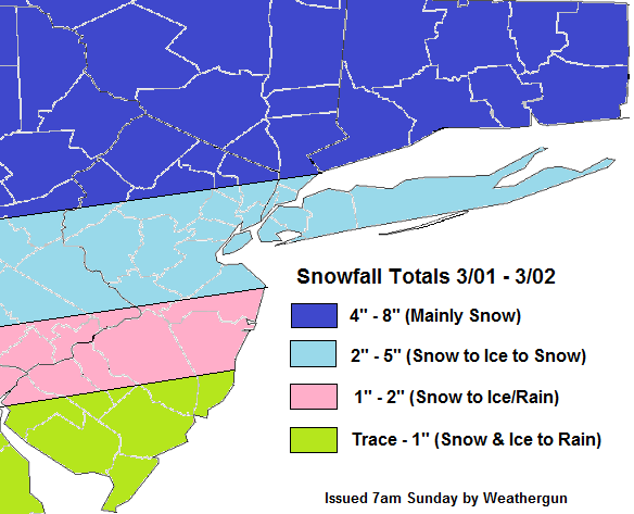
- Comment
- Reblog
-
Subscribe
Subscribed
Already have a WordPress.com account? Log in now.
