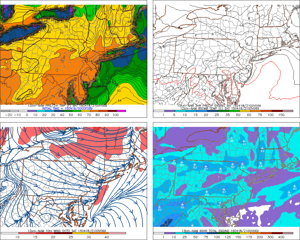
A wind gust to 71mph was reported Philadelphia International Airport yesterday , with a band of showers and embedded thunderstorms along a cold front. This was the forth highest wind gust ever recorded, at the airport. Other strong winds gusts between 55 mph and 65 mph gusts occurred over other parts of Southeast Pennsylvania, and central and southern sections of New Jersey. Some wind gust 45mph-55mph range were recorded some sites over northern New Jersey, the Lower Hudson Valley and New York City. Many of these showers and thunderstorms had weak updrafts due a lack of substantial moisture and CAPE. However, very steep lapse rates helped mixed down stronger winds aloft. This band begin to weaken, as it moved into a more stable marine airmass over over Long Island and Southern Connecticut. More information is below from courtesy of sites such as Storm Prediction Center, Wunderground and the National Weather Service:
Month: April 2015
Heavy Rain & Thunderstorm Threat Monday
After a beautiful weekend, that featured the first 80 degree weather for local area. Some nasty weather is on the way for tomorrow. Fortunately, this storm is just a nuisance for the most part. Still some details for you to be prepared for:
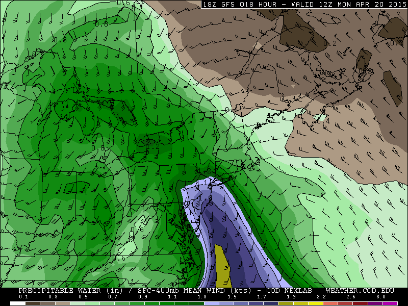
Rainfall: As a warm front with with a wave low approaches, rain will slowly overspread from the southwest the late tonight. A 50kt+ southeasterly low-level jet and a plume of sub-tropical of moisture will provide ample lift and moisture rain to be heavy at times, during the morning and early afternoon hours on Monday. Forecast sounding show a stable airmass during this time frame. So thunderstorms are not expected. Rain will taper off later in the afternoon. As the best forcing with low-level jet starts to shift northeast of the Tri-State area. A cold front may cause a few more showers and thunderstorms tomorrow night. A widespread 1.00″- 1.50″ of rainfall is expected late tonight and tomorrow with locally heavier amounts possible. Some ponding of water in typical poor-drainage or low-lying areas is possible. However, with lack of any significant rainfall recently, more serious flash or river flooding is not anticipated.
Winds: 850mb winds will be running between 50-60kts tomorrow morning and early afternoon. A stable airmass does not support these winds to mix down. However, there could be wind gusts between 30mph and 40mph with the rainfall. Especially near the coast. Also any thunderstorm will be capable of producing stronger wind gusts tomorrow night with the cold front. This is discussed more in the severe weather section below.
Tidal flooding. With the new moon this weekend and the east to southeast flow tomorrow, there could be some minor coastal flooding at high tides tomorrow. Particularly around New York Harbor, the south shores of Long Island and the New Jersey shore. Tides could be 1 to 1 1/2 feet above normal.
Severe Weather: The storm prediction center has issued marginal and slight risks for severe thunderstorms. A cold front associated with this system will move across the area tomorrow night. A deeper southwesterly flow just above the surface, will generate more elevated instability, ahead of this front. More rainfall from more scattered showers and isolated thunderstorms will possible tomorrow night. Any thunderstorm will capable producing heavy rain and gusty winds. But are unlikely to reach severe levels with the warm front remaining south of NYC. Over parts of Central and Southern New Jersey some clearing may take place later tomorrow afternoon. This could atmosphere to destabilize further for stronger thunderstorms with isolated damaging wind gusts.
70s on Saturday..Heavy Rain Monday… Unsettled Weather Through Next Week
Mostly sunny skies are expected today. But it will be not be as warm as than yesterday. With high pressure centered to the east, winds will be more out the east to southeast direction off the colder waters. High temperatures will reach the lower to middle 60s over inland areas. Upper 50s to lower 60s are more likely for high temperatures closer to coast. A weak shortwave trough advancing from the west will increase clouds tonight. Some scattered showers are likely around the area, late tonight and tomorrow morning. Forcing and moisture is limited with this system. So rainfall amounts should be mainly on the light side. High temperatures are expected to be in the middle to upper 60s, with winds more out the southwest with cloud cover.
Yesterday’s temperatures reached the lower 70s. Despite northerly winds and 850mb temperatures of only 4C – 5C during the afternoon. This was due to a downsloping and a deep mixed-layer. Which caused the dewpoints to drop and more dry-adiabatic heating to occur. Model guidance has 850mb temperatures around +8C on Saturday afternoon with a west to northwest downslope flow. This mean high temperatures in the middle to upper 70s, across much of the area. It’s not out question some spots reach 80 degrees. The soundings actually show a deep-mixed layer above between 800mb-850mb, Saturday afternoon. Which often supports temperatures several degrees warmer than model guidance shows.
High pressure will slide off the coast on Sunday. This will cause winds to turn more out of southeast off the cooler ocean. Temperatures will not be as warm as on Saturday. Highs will only reach the lower to middle 60s, away from the shore. Sunday will still be mostly sunny and dry as high pressure will remain in control.
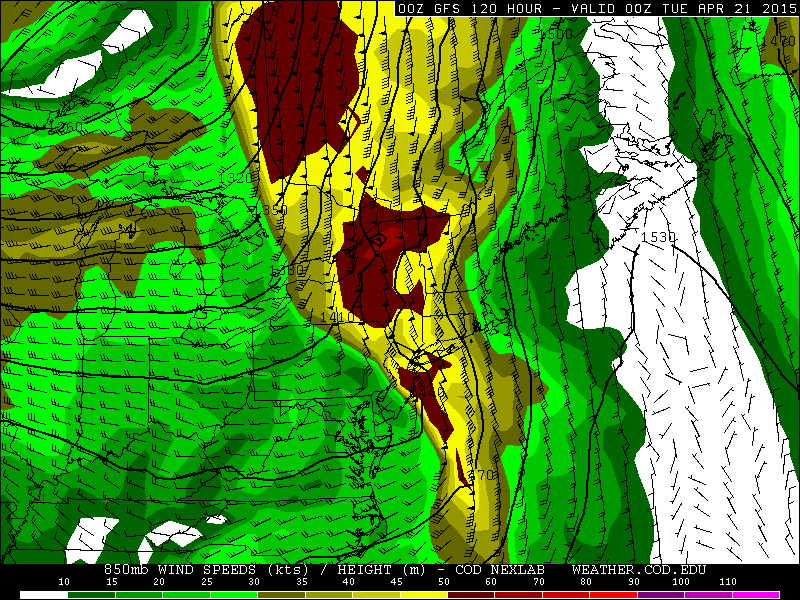
The northern and southern will phase into large upper-level low over Great Lakes region, early next week. A frontal system will move across the area on Monday. A strong southeasterly flow ahead of front, will bring moisture into the region. Model guidance is converging on a triple-point low developing along this front and a 40-50kt 850mb southerly jet moving across the area. These features will enhance more lift, moisture, and some elevated instability over the area on Monday. Precipitable water values between 1.00″ – 1.50″ support widespread rainfall totals over 1″. The pressure gradient between low and the high offshore could also gusts to 40mph, near the coast on Monday. With the new moon this weekend and early next week, this could result in some minor coastal flooding at high tides as well. We are talking about potential, at this point. These details will be fine tuned as we get closer to this event.
Unsettled weather pattern remains after this system, with the large upper-level closed low remains over Great Lakes and a ridge building over Hudson Bay and Davis Strait. A number systems may be coming around this low over the Eastern US. This means weather conditions are likely to vary from day to day. Dependent on timing, some days could still be warm and sunny Other days could be cooler and wetter. As often the case, we will have better idea on the weather each days, as we get closer/

