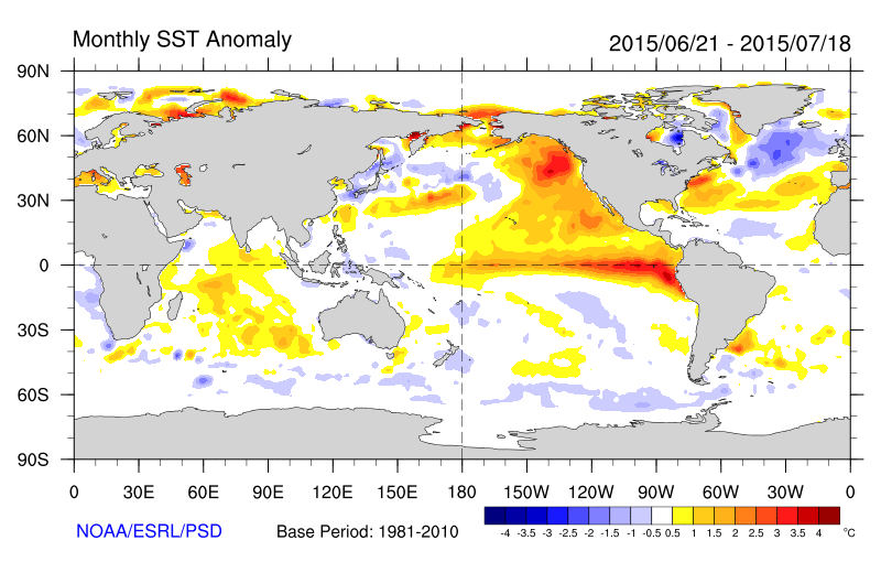
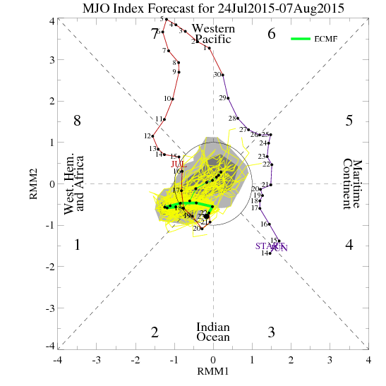
The weather over the last several days has been good as it gets here in late July. Crystal blue skies, some patchy clouds, high temperatures in the 80s, and very low humidity. Climatology records show that these temperatures this actually normal for this time of year. But we are accustomed to seeing more heat and humidity during summer. So far, this summer has seen too much of that. This mainly due the warm pool anomaly in the Northeast Pacific Ocean and a strong MJO in phases 7 and 8 supporting a -AO/NAO, Western US ridge and deeper troughiness over Northeast US over for the late June and early July. The MJO weakening will allow for ridge build in the east again, with more heat and humidity coming for next week.
Year: 2015
Weekend Heavy Rainfall Late Saturday & Better on Sunday 6/27-6/28
High pressure will gradually shift to the northeast Friday night and Saturday. Clouds will increase on Friday night. An amplifying ridge over the Western United States, will cause shortwave energy to dig and form into closed upper-level low over the Ohio Valley/Great Lakes. This will cause a double-barbell surface low-pressure system to organize over the Eastern US on Saturday. A deep southerly flow will transport a plume of moisture from the Gulf of Mexico and the Atlantic into our area. Most of the model guidance agrees on a widespread heavy rainfall throughout the area starting during on Saturday and continue into Saturday night. Saturday will feature mostly cloudy and skies with some intermittent rain and drizzle breaking out from southwest to northwest across the region, during the morning and early afternoon hours on Saturday. A strengthening southerly low-level jet and precipitable water values approaching two inches will cause rain to become steadier and heavier at times, late in the afternoon and early Saturday night for the region. Some of the model guidance shows some elevated instability. So there will there could also be isolated thunderstorm as well. Rainfall totals in excess of 1 or 2 inches are possible and could be enough to cause some flooding in poor drainage or low-lying areas. As surface low pressure and dynamics shift north of the area, rain will begin taper off to lighter showers late Saturday night.
Localized/Isolated Strong-Severe Thunderstorms Possible This Evening
The high resolution models show a pre-frontal and shortwave trough triggering this complex of showers and thunderstorms very late this afternoon or early this evening. The lack of larger-scale ascent or dynamics today, makes a widespread/organized severe event unlikely. But the latest NAM and HRRR 0-6km shear increasing over 30kts and 1500> J/kg of SBCAPE and some steep low-level lapse rates, over parts of Northern New Jersey and the Lower Hudson Valley. This could result in some localized/isolated strong-severe t-storms, in those areas at least. The main threats would be damaging winds, large hail. Some localized flash flooding is possible with pwats over an inch. But these t-storms will be moving at steady pace, as the mid-level flow now looks like it will be a little stronger.
