Snow will overspread the area from southwest to northeast later this morning and this afternoon. Latest NAM and RGEM show snow changing to sleet then freezing rain for many areas NYC and south and east this evening. However, warm air advects northward, between 850-925mb, the thermal gradient will be increasing at this level. This could enhance lifting for a period of moderate to heavy snow before this changeover occursover North-Central NJ, New York City and Long Island. If this changeover before 7pm,then 2″ or 3″ is more likely to occur. If the changeover is delayed just an hour or two 4″ or 5″ are more likely. This even more likely over north shore of LI, parts northern parts of five boroughs, and just north and west of Newark, NJ. Further north over Northernmost New Jersey, the Lower Hudson Valley, and Connecticut is still likely to remain snow. Models since yesterday have increased liquid totals for most of the area. More freezing rain also likely parts for the southern half New Jersey, before a change to rain. As surface temperatures will be slow to rise to just above freezing. The forecast below has been updated to reflect these changes. 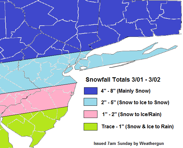
Year: 2015
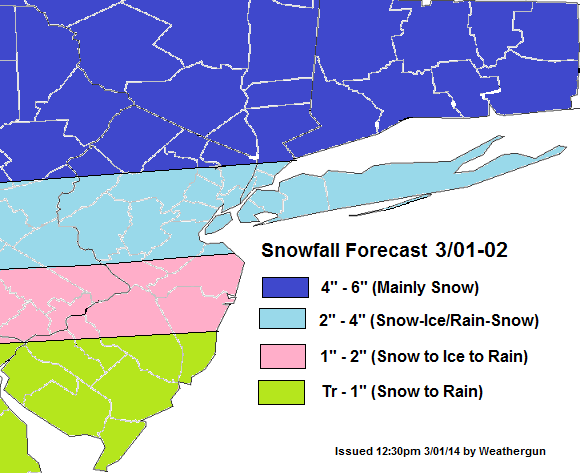
Snowfall Forecast for 3/01-02 Winter Storm
The latest models appear to becoming together on colder and wetter solution for the Tri-state on Sunday afternoon and night. The shortwave trough will cause weak low to from just off the New Jersey or Delaware shores. This will transport more moisture into area and cause the warm front to lift more slowly through region. A strong 700mb-850mb west-southwest jet will also enhance a thermal gradient that will enhancing lifting. At this time, appears most likely over NE NJ, NYC and LI. Models soundings show a warm layer near 900mb that will cause change over to freezing rain for a few hours Sunday evening, in these areas. Before ending as some light snow around daybreak Monday.Just north of this gradient is where precipitation is likely to fall mainly in the form of snow. Although, it’s not of the question some parts of there is brief mix with sleet/freezing rain.

The forecast below a blend of American and Canadian models. Leaning more toward NAM thermal profiles and leaning more towards RGEM/GGEM and GFS liquid forecasts. So this forecast may be update later tonight, after viewing more guidance:
The storm late Tuesday and Wednesday still appears to track over Ohio Valley and Great Lakes. This will cause any frozen precipitation to quickly changeover to rain in our area. However, latest models are indication that this storm’s cold front may slow down with more waves forming along it Wednesday night and Thursday. The outcome comes to the placement of the frontal boundary, the timing of waves moving up the front and whether the upper-level trough can take a more neutral or negative tilt. I will keep an eye on it and hopefully have another update later.
Snow Possible Sunday Night, Then Late Tuesday
After historic cold air for February, a moderating trend appears to be in store as we go into March. However the threat more winter storms will continue longer. Today most of region misses out on significant snowstorm to our south. Southern New Jersey saw several inches of snow today. While the rest of the area are saw just snow showers or flurries with very little accumulation. The -PNA (negative Pacific North American Oscillation) will support a storm track further north over the Central and Eastern US for the first week of March.
Currently model guidance shows an upper-level shortwave trough and weak surface low pressure moving through late Sunday afternoon and Sunday night. Model thermal profiles support mainly snow from this system from Central New Jersey . Some light to moderate snowfall accumulations are possible here. This will be fast mover and not a big storm. But light to moderate snowfall accumulations will be possible. This could make for Monday morning commute to work or school hazardous. Again this event just a possibility. We will have to monitor future models for more consistency and details. A small change in the track or strength of this system could result in less precipitation or more of a wintry mix for parts of the area.

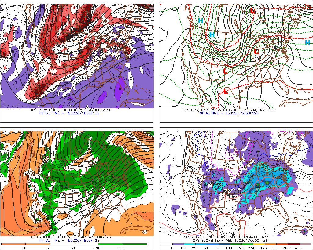
Model guidance is also showing a much larger storm system coming out of the Central Plains, Tuesday afternoon into Wednesday for the Northeast and Mid-Atlantic regions. Some very cold will be already in place on Tuesday morning in the Tri-state area. But the model consensus today is for this storm to to track to over to our west over the Ohio Valley and Great Lakes. Which brings low-level and mid-level warming for any snow and ice to change to rain by late Tuesday night or early Wednesday morning. At this time, the pattern shown on the models would support this solution. There is a deep trough over West Coast and strong ridge over the Southeast US. There is also upper-level low over Western Canada and the could pull this storm further north. The polar vortex is also lifting out SE Canada quickly, without enough high-latitude blocking. However, there is still plenty of time for details to change. For example, if Sunday night system is stronger and phasing with the polar vortex over Southeast Canada, this could cause more confluence and cold high pressure over Northeast. That would force a secondary low off too form off the East coast and at least slow down the warm air intrusion. This would result in heavier snowfall totals or more significant icing. It is possible, the models may not catch on to a solution like this until Monday. I will continue to monitor this system through early next week for any significant changes