Late February & Early March Outlook

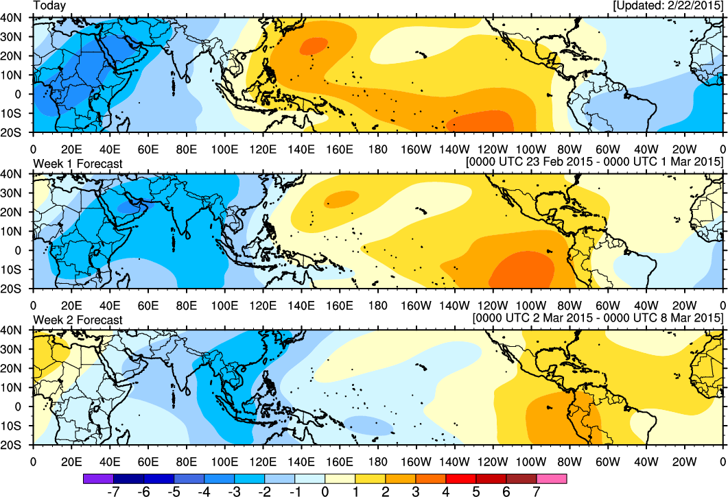
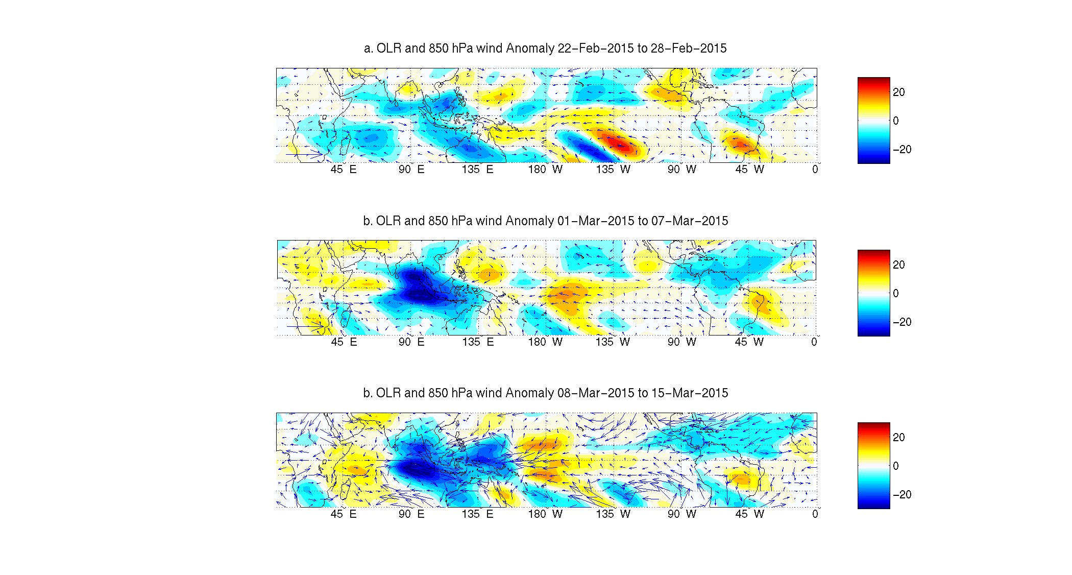
Over the last few weeks, we’ve been in a pattern that has feature more extreme arctic intrusion that with the low temperatures that we have for NYC in many years.  Record lows where shattered on Friday morning over the Tri-State area. What is amazing is that we seen the Artic Oscillation and North Atlantic Oscillation remain positive. The arctic air is from a combination -EPO and +PNA. The question is how long does this pattern continue. Well the models and ensembles show -EPO/+PNA gradually retrograding into Central Pacific, over next two weeks. Some support for this pattern change is the MJO looking become neutral to unfavorable the next few weeks. As tropical forcing at 200mb and 850mb diminishes in Western Hemisphere and reemerges over the Indian Ocean and Indonesia, during the 2-3 weeks.

200vp anomalies
200mb anomalies forecast to shifting over Indian Ocean and Indonesia
850mb OLR and Wind Anomalies shifting the MJO/tropical convection into Indian Ocean and Indonesia/
850mb OLR and Wind Anomalies shifting the MJO/tropical convection into Indian Ocean and Indonesia over the next 2 weeks

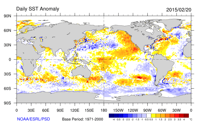
However, the Pacfic SSTs continue to show a strong +PDO and weak, west-based +ENSO. If there’s no change here, this could support a reload of -EPO/+PNA again sometime in March, provided we see the forcing mechanism for it again.

Sea-Surface Temperature Anomalies
Sea-Surface Temperature Anomalies still warm over Eastern Pacific

The ECMWF shows more perturbations with the stratospheric vortex over next 10 days. However, these perturbations appear to be related to changes in troposphere or 200mb-500mb level. There is no significant warming or decrease in westerly winds occurring at 10mb and 60N. Despite more significant warming episodes previously, the stratospheric vortex has remained intact for most part this winter, particularly at 50mb. So I think the AO and NAO will continue remain largely on the positive side going into March  Some weak or transient -AO/-NAO episodes are possible from time to time with each polar vortex perturbation.

ECMWF model forecasting little change with stratosphere temperatures and wind not decreasing
ECMWF model forecasting little change with stratosphere wind,fluxes and temperatures at between 60-90N

For sensible weather in the Tri-state area, I expect very cold air intrusions to continue this week. Then a gradual moderating trend with temperatures during the first ten days of March. Temperatures will still likely average below normal. But should come out of the deep freeze that we’ve seen the past couple weeks.  The southern stream remains active enough, to keep potential going for more wintry threats in this pattern.  However, with the lack of high-latitude blocking and a sustained West Coast ridge,  don’t expect anything major or historic for the Tri-State area. Chances are flow will wind being too fast over the area, for any cold high pressure to remain to our north or the trough to take extreme negative tilt and close off at 500mb. Parts of Northern and Central New England, which has seen historic snowfall this year, may a different story. But even there the pattern may be to progressive. When any threat on the models appears to be legit, I will discuss more in the wintry wx section.


More Snow This Weekend

Another moderate-sized winter storm is on the way for region today. A wave of low pressure over Southern Plains will track into Ohio Valley today The warm front associated with this system, will move northward into northern Mid-Atlantic region. As this warm front approaches, precipitation will overspread the area from southwest to northeast this afternoon. Currently we have very cold deep cold airmass in place, that caused record lows over Tri-State area early yesterday morning. It will be in form of snow for initially everyone.  A strengthening southwesterly low-level jet help push this warm front through the area tonight. Causing snow to change over sleet/freezing and then plain rain.  However, this low-level jet will cause enhance more isentropic lift and moisture advection. This mean some heavy snowfall rates in the order of at least 1″-2″ per hour, before a any changeover.

00z GFS showing 850 southwesterly jet greater than 50-60kt tomorrow evening.
00z run of the GFS showing 850 southwesterly jet at 50-60kts tonight

What is problematic here, is  exactly when the changeover will occur or how much snow will fall before then. There are some models differences on such issues, especially from NYC metro area and southeast. The snowfall forecast, is my best idea on how how much snow will fall parts of the Tri-state. There is a possibility for heavier snowfall totals, if more heavy precipitation occurs. On the other hand, snowfall totals maybe lower if warm air winds out aloft. High pressure offshore supports a southwest flow tomorrow. Either way heavy snowfall rates are likely cause problems for anyone commuting especially late this afternoon and early tonight. Precipitation is expected to come to end late tonight or early tomorrow morning for all areas. Temperatures may rise into 40s tomorrow, before a cold front swings through later tomorrow and brings back into the teens and single digits for Monday.

Snowfallmap21-22

Next Moderate Winter Storm 2/17/15

The past weekend storm once again, produce less snowfall many areas. Exception here in is Central and Southern NJ, where the inverted trough unexpectedly setup there. I will do some post-mordem on it this week. But another winter storm is already on it’s way for tonight. The snowfall forecast is after the end of this discussion.

A low pressure that is producing snow and ice over Central Plains and the Tennessee Valley, will stay south of the area through early this evening. Then as an upper-level low over the Canadian Martimes to lifts out, this storm will head more northeast towards the area tonight. The question here, is how much room will this storm have to come northward? Enough confluence from the upper-level low could lead to sharp cut-off of snowfall totals in the Tri-State area. Models are also indicate that 500mb shortwave energy for this system will tend to weaken a bit as moves into the Ohio Valley and Mid-Atlantic. However, there is fairly strong 700-8500mb southwesterly jet associated with this system. This could help enhance warm-air advection on top very cold airmass, currently in place. There some models on amount of lift and moisture that will be able to make to parts of Tri-State area. Also snow to rain ratios will be higher with very cold airmass aloft. The snow growth region ins 10C-20C layer. Ratios could be as high 25 to 1, especially if more lift and moisture is realized.

This is not a very powerful or explosive Nor’easter type storm. The southern stream system that will tapping to more Gulf of Mexico moisture then many of our systems have this season. However, it will be a fast-moving system, with not enough of blocking in the Atlantic. Snow will move in from southwest later this evening and last through early tomorrow morning. Snow will have difficult time making far north into the Hudson Valley and CT. While snow be steadier and heavier the farther south, especially over Central and Southern NJ. Snow should mid to late morning for all areas and skies should clear in the afternoon.

Snowfallmap1216