Record low temperatures were set this morning in the following locations:
LGA 23 Old Record 24 in 1975
JFK 23 Old Record 24 in 2001
ISP 22 Old Record 22 in 2001
EWR 22 Old Record 23 in 2001
We recovered nicely into to lower and middle 40s this afternoon. Which is still 10 degrees below normal. Party cloudy skies are expected tonight. Then it will mostly cloudy tomorrow morning. A cold front will move through the region tomorrow evening. Ahead of is 50kt-60kt low-level jet and precipitable water values (pwats) around .75″. This could some showers to develop tomorrow afternoon and evening. Heavy rainfall is not expected however. Amounts .25″ at best likely.
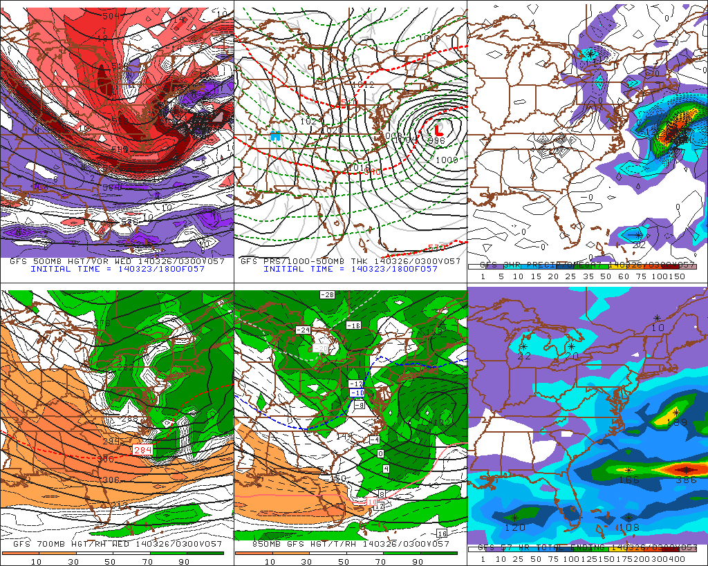
Shortwave energy will cut-off to our southwest on Saturday. As this system approaches our area, rain moving in from south to north. Rain is likely fall heavy times Saturday night into perhaps Sunday. 200mb-500mb jet streaks are positioned favorably for upper-level divergence (forcing). The cut-off low intensifies and takes negative tilt over Ohio Valley. This causes surface low pressure to form along the coast. Warmer, moist air will be transported with developing low-level jet. The heaviest rainfall is likely to occur with the best moisture convergence setup near the low-level jet and pwat axis. As the 18z run of the GFS shows for Long Island and Connecticut:
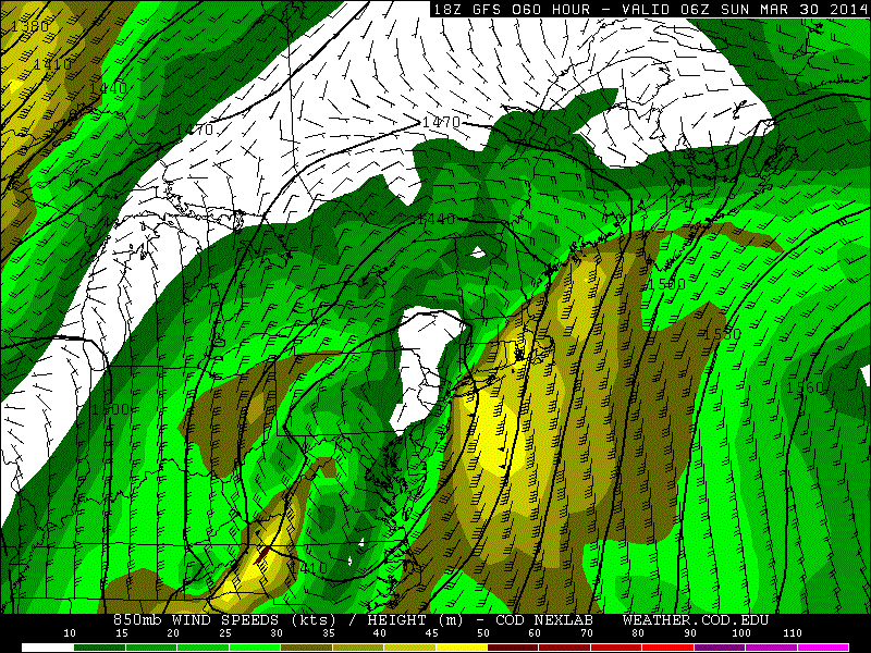
Overall it seems most areas are likely to receive at least 1-2″ of rain from this storm. With parts of the area receiving up to 3 or 4 inches of rain. Winds may also gust between 35mph to 45mph, near the coast on Sunday, with low-level lapse rates steepening and low-level jet in the area.The pattern will remain progressive overall with a parade of Pacific systems coming into Western and Central US. This will force this storm to move out of the region by Monday. With fair weather returning for much of next week. Temperatures will also be closer to normal in the 50s and 60s for highs.
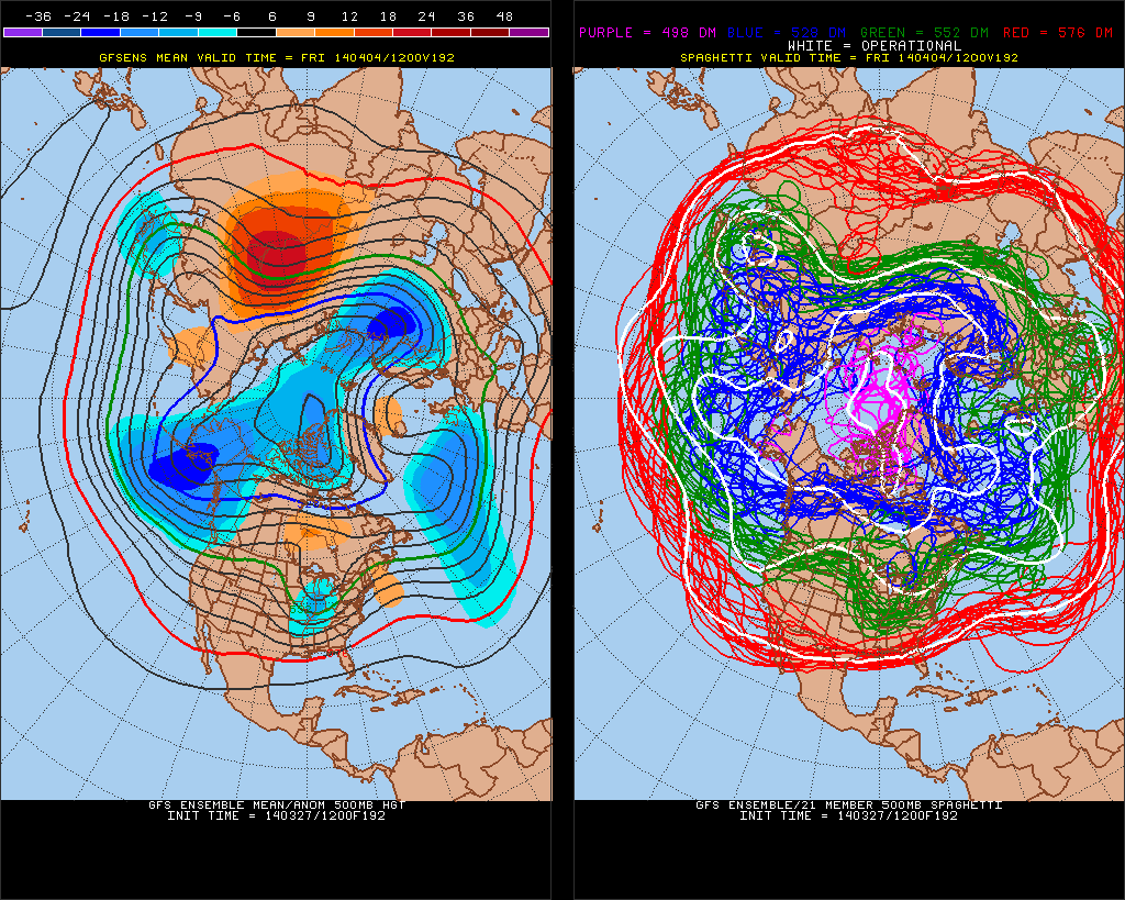
The 12z GEFS hints another large storm system over Eastern US, about a week from now. However, with the polar vortex retreating into North Pole, artic/polar air source, will likely be shutoff next week. We may see Pacific shortwave energy to cut-off again and bring more heavy rain to the area. Still very far out for any details:
5:00pm 3/27 Update: Wreckhouse, Newfoundland recorded sustained winds near 83mph with gusts to near 116mph around 8:30pm NDT, March 26 (Winds below are km/h):
Storm Reports from NWS Boston office:
0623 AM     NON-TSTM WND DMG SANDWICH                41.76N  70.50W
03/26/2014                   BARNSTABLE         MA   AMATEUR RADIO

            WIRES DOWN ON STRUCTURE ON FOSTER ROAD CAUSING A FIRE


0750 AM     NON-TSTM WND DMG NANTUCKET               41.27N  70.10W
03/26/2014                   NANTUCKET          MA   AMATEUR RADIO

            LARGE BRANCH DOWN ON HIGHLAND AVE BLOCKING ROAD

0805 AM     COASTAL FLOOD    PLYMOUTH                41.96N  70.68W
03/26/2014                   PLYMOUTH           MA   AMATEUR RADIO

            WARREN AVE CLOSED DUE TO COASTAL FLOODING

0810 AM     COASTAL FLOOD    NANTUCKET               41.27N  70.10W
03/26/2014                   NANTUCKET          MA   TRAINED SPOTTER

            COASTAL FLOODING AT STRAIGHT WARF

0817 AM     NON-TSTM WND GST NANTUCKET               41.27N  70.10W
03/26/2014  M78 MPH          NANTUCKET          MA   AMATEUR RADIO

            HAM RADIO

0820 AM     COASTAL FLOOD    NANTUCKET               41.27N  70.10W
03/26/2014                   NANTUCKET          MA   AMATEUR RADIO

            MINOR COASTAL FLOODING ON EASY STREET BY BRANT POINT

0849 AM     NON-TSTM WND GST NANTUCKET               41.28N  70.10W
03/26/2014  M72 MPH          NANTUCKET          MA   HAM RADIO

            HAM RADIO

0915 AM     NON-TSTM WND DMG NANTUCKET               41.27N  70.10W
03/26/2014                   NANTUCKET          MA   AMATEUR RADIO

            SEVERAL LARGE BRANCHES DOWN ON EAST END OF THE ISLAND.
            WIRES DOWN WITH REPORTED 1200 HOMES WITHOUT POWER.

0916 AM     NON-TSTM WND DMG WEST YARMOUTH           41.65N  70.24W
03/26/2014                   BARNSTABLE         MA   AMATEUR RADIO

            WIRES DOWN


0950 AM     COASTAL FLOOD    NANTUCKET               41.27N  70.10W
03/26/2014                   NANTUCKET          MA   EMERGENCY MNGR

            EMD REPORTS MAJOR COASTAL FLOODING IN BRANT POINT
            SECTION OF NANTUCKET


1001 AM     NON-TSTM WND DMG WEST BARNSTABLE         41.71N  70.37W
03/26/2014                   BARNSTABLE         MA   AMATEUR RADIO

            POWER OUTAGES


1055 AM     NON-TSTM WND DMG NORTH PROVIDENCE        41.86N  71.46W
03/26/2014                   PROVIDENCE         RI   AMATEUR RADIO

            TREE DOWN MEDCALF AT WYNONA STREET BLOCKING ROAD

1059 AM     NON-TSTM WND DMG PLYMOUTH                41.96N  70.68W
03/26/2014                   PLYMOUTH           MA   AMATEUR RADIO

            TREE AND WIRES DOWN ON STATE ROAD

1105 AM     NON-TSTM WND DMG MASHPEE                 41.65N  70.48W
03/26/2014                   BARNSTABLE         MA   AMATEUR RADIO

            WIRES DOWN ON MASHPEE NECK ROAD

1106 AM     NON-TSTM WND DMG HARWICH                 41.69N  70.07W
03/26/2014                   BARNSTABLE         MA   AMATEUR RADIO

            LARGE BRANCH AND WIRES DOWN ON BANK STREET

1114 AM     NON-TSTM WND DMG NANTUCKET               41.27N  70.10W
03/26/2014                   NANTUCKET          MA   AMATEUR RADIO

            MILESTONE ROAD BLOCKED BY MULTIPLE TREES DOWN AND SNOW
            DRIFTS

1115 AM     NON-TSTM WND DMG YARMOUTH                41.71N  70.23W
03/26/2014                   BARNSTABLE         MA   AMATEUR RADIO

            TREE ON HOUSE ON CASEY STREET

1126 AM     NON-TSTM WND DMG WEST HARWICH            41.67N  70.12W
03/26/2014                   BARNSTABLE         MA   AMATEUR RADIO

            TOP HALF OF TREE DOWN ON BAY PORT ROAD

1130 AM     NON-TSTM WND DMG DENNIS                  41.73N  70.20W
03/26/2014                   BARNSTABLE         MA   AMATEUR RADIO

            TREE AND WIRES DOWN ON DEPOT STREET

1136 AM     COASTAL FLOOD    SCITUATE                42.19N  70.73W
03/26/2014                   PLYMOUTH           MA   AMATEUR RADIO

            OVERWASH WITH DEBRI ON CENTRAL AVE AND COLE PARKWAY

1136 AM     COASTAL FLOOD    SANDWICH                41.76N  70.50W
03/26/2014                   BARNSTABLE         MA   AMATEUR RADIO

            EROSION FROM COASTAL FLOODING TO WITHIN 7 FEET OF A
            HOUSE ON WHITE CAP PATH

1136 AM     COASTAL FLOOD    SANDWICH                41.76N  70.50W
03/26/2014                   BARNSTABLE         MA   AMATEUR RADIO

            TOWN NECK BEACH OVERWASHED

1137 AM     NON-TSTM WND GST BARNSTABLE              41.70N  70.30W
03/26/2014  M60 MPH          BARNSTABLE         MA   AMATEUR RADIO

            MARSTON MILLS

1140 AM     COASTAL FLOOD    CHATHAM                 41.68N  69.96W
03/26/2014                   BARNSTABLE         MA   AMATEUR RADIO

            FISHING PIER PARKING LOT FLOODED

1141 AM     COASTAL FLOOD    DENNIS                  41.73N  70.20W
03/26/2014                   BARNSTABLE         MA   AMATEUR RADIO

            SESUIT HARBOR PARKING LOT FLOODED

1142 AM     COASTAL FLOOD    DENNIS                  41.73N  70.20W
03/26/2014                   BARNSTABLE         MA   AMATEUR RADIO

            CHAPMIN BEACH ACCESS RAMP ERRODED AWAY

1151 AM     NON-TSTM WND DMG BREWSTER                41.75N  70.08W
03/26/2014                   BARNSTABLE         MA   AMATEUR RADIO

            TREE DOWN ON MAIN STREET

1201 PM     NON-TSTM WND DMG BREWSTER                41.75N  70.08W
03/26/2014                   BARNSTABLE         MA   AMATEUR RADIO

            TREE DOWN ON LONG POND ROAD NEAR ROUTE 137

1215 PM     NON-TSTM WND DMG BREWSTER                41.75N  70.08W
03/26/2014                   BARNSTABLE         MA   AMATEUR RADIO

            WIRES DOWN ON STONEY BROOK ROAD

1220 PM     NON-TSTM WND DMG CAMBRIDGE               42.38N  71.12W
03/26/2014                   MIDDLESEX          MA   AMATEUR RADIO

            TREE DOWN FAYERWEATHER STREET

1227 PM     NON-TSTM WND GST 2 NE HYANNIS            41.67N  70.27W
03/26/2014  M64 MPH          BARNSTABLE         MA   ASOS

            HYANNIS AIRPORT ASOS

1235 PM     NON-TSTM WND DMG BOSTON                  42.32N  71.07W
03/26/2014                   SUFFOLK            MA   AMATEUR RADIO

            DOWN POWER LINES ALSTON AND RUTHERFORD STREETS

1240 PM     NON-TSTM WND DMG UPTON                   42.17N  71.61W
03/26/2014                   WORCESTER          MA   AMATEUR RADIO

            TREE AND WIRES ON FOWLER ROAD

1240 PM     NON-TSTM WND DMG UPTON                   42.17N  71.61W
03/26/2014                   WORCESTER          MA   AMATEUR RADIO

            TREE ON CAR ON MENDON STREET

0114 PM     NON-TSTM WND DMG SOUTH DENNIS            41.69N  70.16W
03/26/2014                   BARNSTABLE         MA   AMATEUR RADIO

            TREE ON HOUSE

0145 PM     NON-TSTM WND DMG BOSTON                  42.32N  71.07W
03/26/2014                   SUFFOLK            MA   AMATEUR RADIO

            LIMBS DOWN ON ALLSTON STREET

0154 PM     NON-TSTM WND DMG WILMINGTON              42.56N  71.17W
03/26/2014                   MIDDLESEX          MA   AMATEUR RADIO

            TREE DOWN ON FOREST STREET

0155 PM     NON-TSTM WND DMG WELLESLEY               42.30N  71.29W
03/26/2014                   NORFOLK            MA   AMATEUR RADIO

            UTILITY POLE DOWN ON SYLVAN ROAD

0231 PM     NON-TSTM WND DMG BOSTON                  42.32N  71.07W
03/26/2014                   SUFFOLK            MA   AMATEUR RADIO

            WIRES DOWN ON BRONX ROAD

0242 PM     NON-TSTM WND DMG NASHUA                  42.75N  71.49W
03/26/2014                   HILLSBOROUGH       NH   AMATEUR RADIO

            TREE AND WIRES DOWN ON CHESTNUT STREET CLOSING THE
            STREET
PUBLIC INFORMATION STATEMENT
NATIONAL WEATHER SERVICE TAUNTON MA
1002 AM EDT WED MAR 27 2014

...BLIZZARD CONDITIONS OCCURRED ON CAPE COD AND THE ISLANDS
WEDNESDAY...

BLIZZARD CONDITIONS WERE REACHED AT FALMOUTH...HYANNIS...AND CHATHAM
ON CAPE COD...ON MARTHAS VINEYARD...AND ON NANTUCKET ON WEDNESDAY
MARCH 26 2014.

THE DEFINITION OF A BLIZZARD IS THAT FALLING AND/OR BLOWING SNOW
REDUCES VISIBILITY TO BELOW 1/4 MILE ALONG WITH WINDS THAT
FREQUENTLY GUST TO 35 MPH OR MORE...AND THAT THESE CONDITIONS ARE
THE PREDOMINANT REPORTED CONDITION FOR 3 CONSECUTIVE HOURS.

WHEN REVIEWING WHETHER A PARTICULAR OBSERVATION LOCATION HAD
BLIZZARD CONDITIONS...WE COUNTED VISIBILITIES EQUAL TO 1/4 MILE
BECAUSE IT IS QUITE LOW FOR AN AUTOMATED VISIBILITY SENSOR TO BE
ABLE TO DETECT. WHERE 1/4 MILE VISIBILITY WAS REPORTED
CONTINUOUSLY...IT WAS ASSUMED THAT IT WAS ALSO BELOW 1/4 MILE AND
THEREFORE MET BLIZZARD CRITERIA.

AT CHATHAM MA...BLIZZARD CONDITIONS OCCURRED FOR MORE THAN
7 HOURS...FROM 517 AM TO 1231 PM.

AT HYANNIS MA...BLIZZARD CONDITIONS OCCURRED FOR MORE THAN
6 HOURS...FROM 543 AM TO 1155 AM.

ON NANTUCKET MA...BLIZZARD CONDITIONS OCCURRED FOR MORE THAN 6
HOURS AT THE AIRPORT...FROM 635 AM TO 1253 PM.

AT FALMOUTH MA...BLIZZARD CONDITIONS OCCURRED FOR 4 HOURS...
FROM 655 AM TO 1054 AM.

ON MARTHAS VINEYARD MA...BLIZZARD CONDITIONS OCCURRED FOR MORE THAN
3 HOURS AT THE AIRPORT...FROM 725 AM TO 1053 AM.

IT SHOULD BE NOTED THAT PLYMOUTH MA ALMOST REACHED BLIZZARD
CONDITIONS. THEY OCCURRED FOR JUST LESS THAN 3 HOURS AND THEY WERE
DISCONTINUOUS FOR A HALF-HOUR PERIOD WITHIN THAT TIME FRAME.

$$
FIELD
MASSACHUSETTS

...BARNSTABLE COUNTY...
   HARWICHPORT            6.0  1157 AM  3/26  HAM RADIO
   EAST FALMOUTH          5.5   137 PM  3/26  NONE
   WEST YARMOUTH          5.0  1034 AM  3/26  HAM RADIO
   BREWSTER               5.0  1155 AM  3/26  HAM RADIO
   HARWICH                4.0   910 AM  3/26  HAM RADIO
   WELLFLEET              4.0  1039 AM  3/26  HAM RADIO
   WEST HARWICH           4.0   938 AM  3/26  HAM RADIO
   BOURNE                 3.3   308 PM  3/26  NWS EMPLOYEE
   CENTERVILLE            1.3   724 AM  3/26  TRAINED SPOTTER
   WAQUOIT                1.0   604 AM  3/26  HAM RADIO
   EASTHAM                1.0   615 AM  3/26  HAM RADIO

...BRISTOL COUNTY...
   WEST ACUSHNET          1.0  1235 PM  3/26  HAM RADIO
   NEW BEDFORD            1.0  1231 PM  3/26  HAM RADIO
   SEEKONK                0.5  1142 AM  3/26  GENERAL PUBLIC

...DUKES COUNTY...
   EDGARTOWN              3.5   930 AM  3/26  CO-OP
   WEST TISBURY           1.3   607 AM  3/26  HAM RADIO

...NANTUCKET COUNTY...
   NANTUCKET              9.5  1208 PM  3/26  HAM RADIO

...PLYMOUTH COUNTY...
   PLYMOUTH               2.0  1202 PM  3/26  PINE HILLS

RHODE ISLAND

...NEWPORT COUNTY...
   MIDDLETOWN             0.5   533 PM  3/26  TRAINED SPOTTER
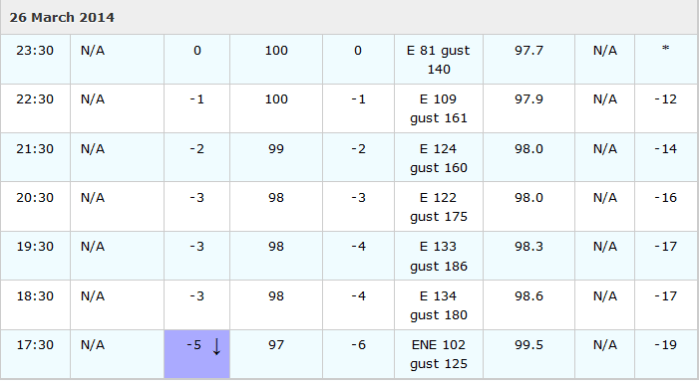
8:00am 3/27 Update: A Davis Weather Station on Machias Seal Island, in Bay of Fundy, recorded a 129mph wind gust at 3:52pm:
Buoy 44027, off Johnston, Maine recorded wind gusts up 118mph, before it stopped reporting during the late afternoon and early evening:
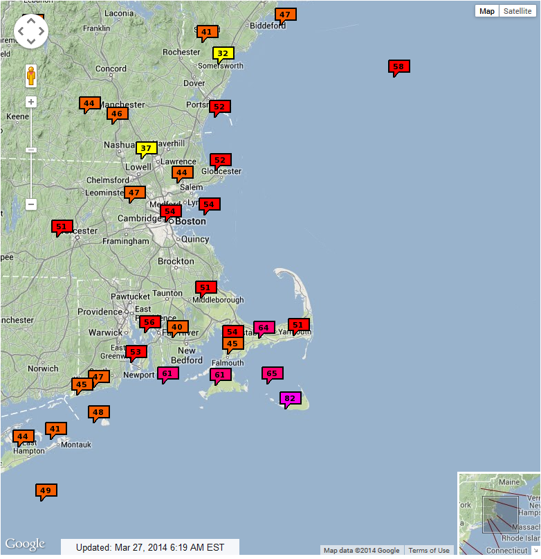
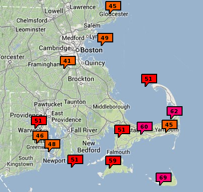
Highest winds for coastal New England, were over Nantucket. Where 82-83mph gusts were recorded at airport and reported by ham radio:
...NANTUCKET COUNTY...
   NANTUCKET               83   830 AM  3/26  HAM RADIO
   2 ESE NANTUCKET         82  1100 AM  3/26  ACK AIRPORT ASOS
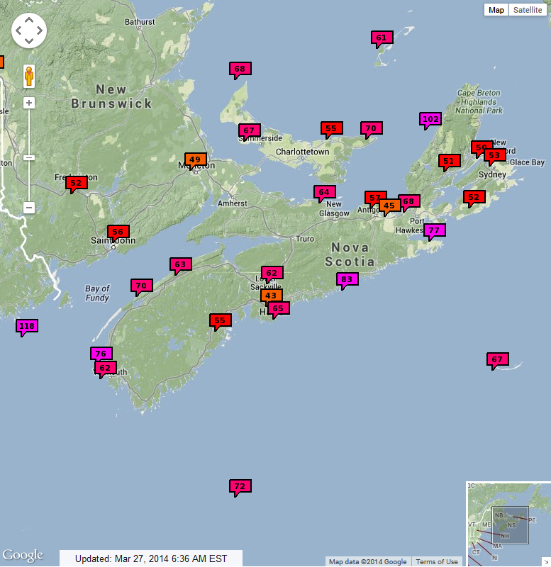
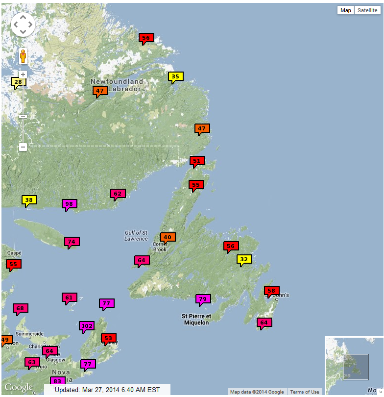
Maps with the peak wind gusts from this storm reported over Coastal New England and Atlantic Canada:
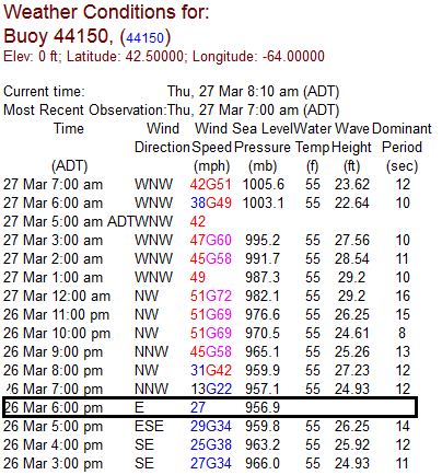
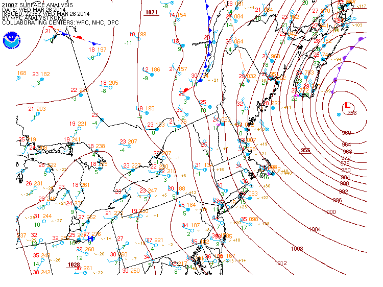
Lowest pressure recorded was 956.9mb at buoy 44150 at 7pm yesterday. WPC estimated minimum central pressure at 955mb at 21z Wednesday:
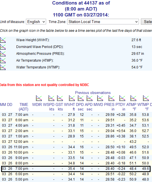
Wave heights as high 35.4 feet were reported by buoy 44137, south of Nova Scotia:
Reporters from “The Weather Network” were in Grand Etang, Nova Scotia yesterday. Were winds gust up to 107mph were recorded:
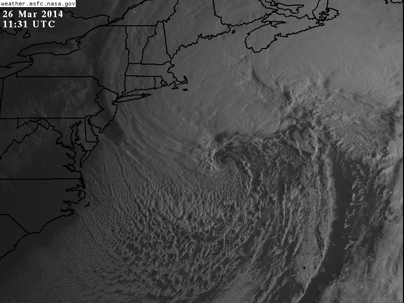
NASA satellite image of the storm:
Another update on damage and snowfall reports will be coming today.
10am 3/26 Update: Nantucket just reported a peak 64kt (74mph) gust in past hour. 69mph gust as top the hour, with heavy snow and 1/4 mile visibility reported
Winds are starting to pick up closer to our area. But should be gusts should be between 40-50mph.
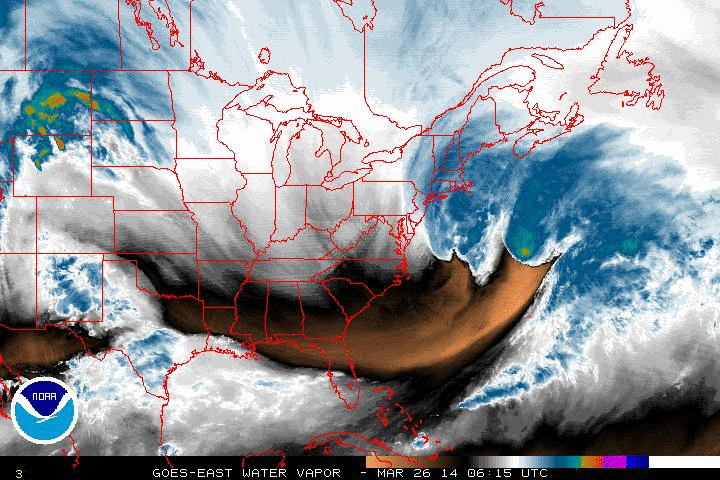
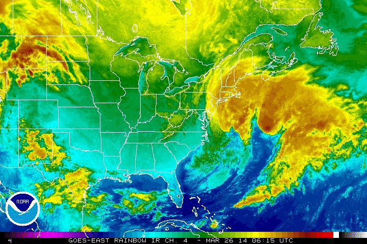
Here are some latest satellite and water vapor loops of the in these incredible storm:
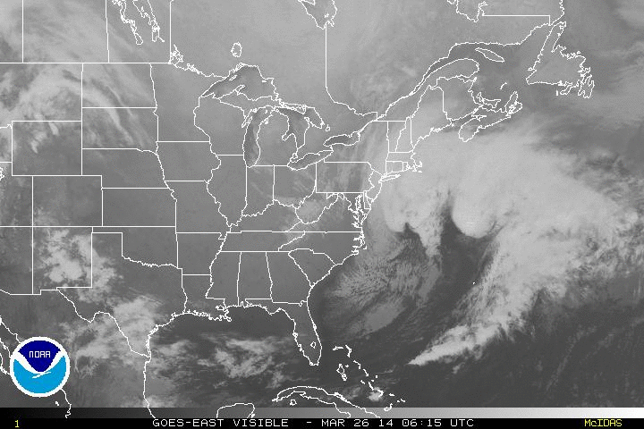
8am 3/26 Update: First amazing visible satellite image of the powerful storm offshore:
In, Nantucket a wind gust of 78 mph gust, reported by Ham Radio operartor. Other wind gusts around Cape Cod have been in excess of 50mph and 60mph. Blizzard conditions with heavy snow and 1/4 mile visibility is also occurring in Nantucket. This continue for another few hours this morning. Storm pressure currently at 972mb according to WPC. More updates to come soon.
0817 AM     NON-TSTM WND GST NANTUCKET               41.27N  70.10W
03/26/2014  M78 MPH          NANTUCKET          MA   AMATEUR RADIO

            HAM RADIO
A powerful nor’easter will form off the East Coast, on Tuesday night and Wednesday. But model guidance have consensus that this storm will stay far enough east of our area. Sparing the tri-state area of major snowfall and strong winds. As I previous discussed in the last blog post, there were number factors that had to be resolved for this storm to come together. All guidance is now in consistent agreement, that the Pacific upper-level low will open up into smaller systems and the coming into West Coast faster. Another lobe of polar vortex coming down from Central Canada, will also aid breaking down ridge further. This causes a broader trough over the Eastern US and later, sloppy phasing of northern and southern stream disturbances. The end result a storm slower to organize off Mid-Atlantic coast. By the time this consolidates into one very deep storm, it’s more than 200 miles east of New Jersey.
A lighter snowfall is still possible for parts of the area Tuesday late afternoon and night. The guidance has been showing an inverted trough extending from the storm offshore. However, this placement and intensity of this feature is often difficult for models to handle. The 18z NAM today shows inverted trough with a moderate band of snow reach the NJ shore. While the 18z GFS just shows scattered snow showers with the inverted trough. Both model notably keep the 500mb vort max and PVA well south of the area. Which leads me to believe this feature will not be very impressive for region. I will still monitor this storm for any changes. But at this time it’s not looking like big deal for our area.
 Overall it seems most areas are likely to receive at least 1-2″ of rain from this storm. With parts of the area receiving up to 3 or 4 inches of rain. Winds may also gust between 35mph to 45mph, near the coast on Sunday, with low-level lapse rates steepening and low-level jet in the area.The pattern will remain progressive overall with a parade of Pacific systems coming into Western and Central US. This will force this storm to move out of the region by Monday. With fair weather returning for much of next week. Temperatures will also be closer to normal in the 50s and 60s for highs.