Rain Today, Strong Thunderstorms Possible Friday

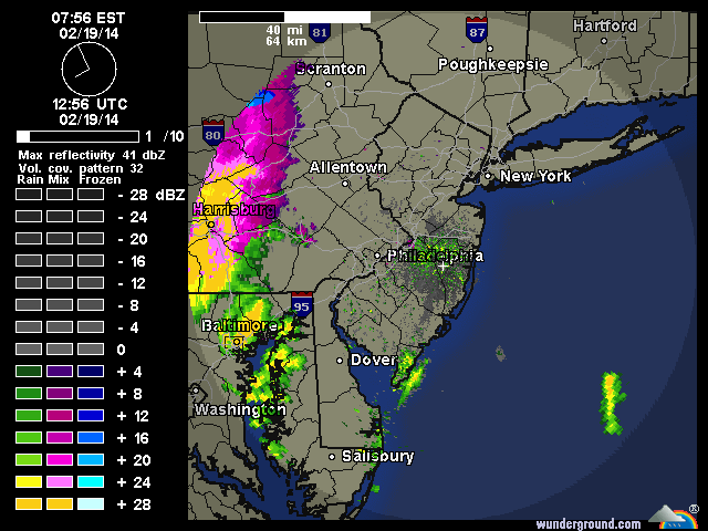
A frontal system and strong shortwave trough will give the region a period of rain from later this morning into this afternoon.  The rain can be seen on radar over PA. Temperatures aloft are enough for the area to only see rainfall from this event. However, surface temperatures may be slow to rise above freezing, due to the snowpack. Which could cause rain to freeze on surfaces. Especially north and west of NYC. Therefore, the National Weather Service has issued a Freezing Rain Advisory for NW NJ and Orange and Rockland Counties in NY. Rainfall totals are likely between .25″ – .50″ across the area. So no significant flooding is expected. However snow melt today may cause some ponding on the roadways. So wear waterproof boots. Rain should ending this evening.

Radar2
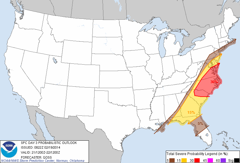
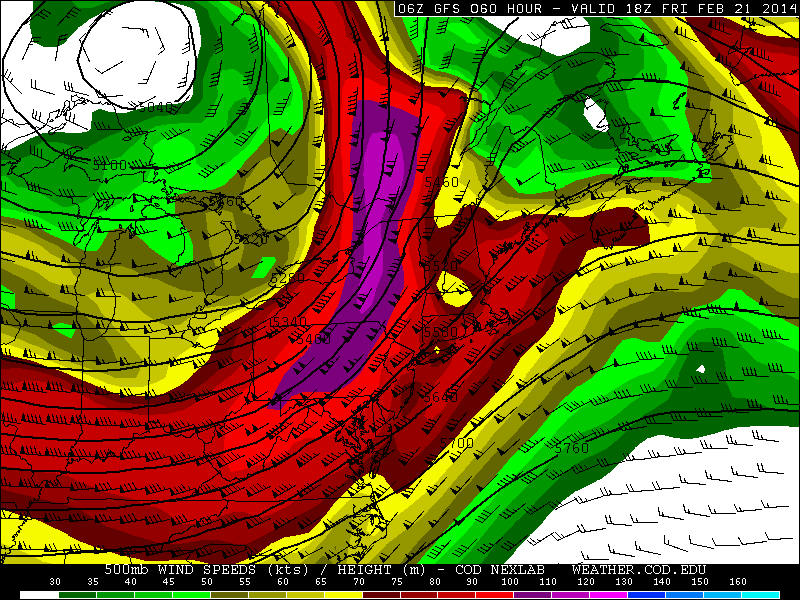
A cold front will move through on Friday, with some showers and possibly some thunderstorms. SPC has places southern parts of the tri-state area in a 5% or 15% risk for thunderstorms with damaging wind gusts. Models don’t show any surface-based instability. So severe weather is not likely. But with a strong 500mb jet streak and some elevated instability there is potential for a forced low-topped squall line that produce wind gusts of at least 40mph. Temperatures will also likely rise into 50s ahead of this front.

day3prob_0830
gfsNE_500_spd_060
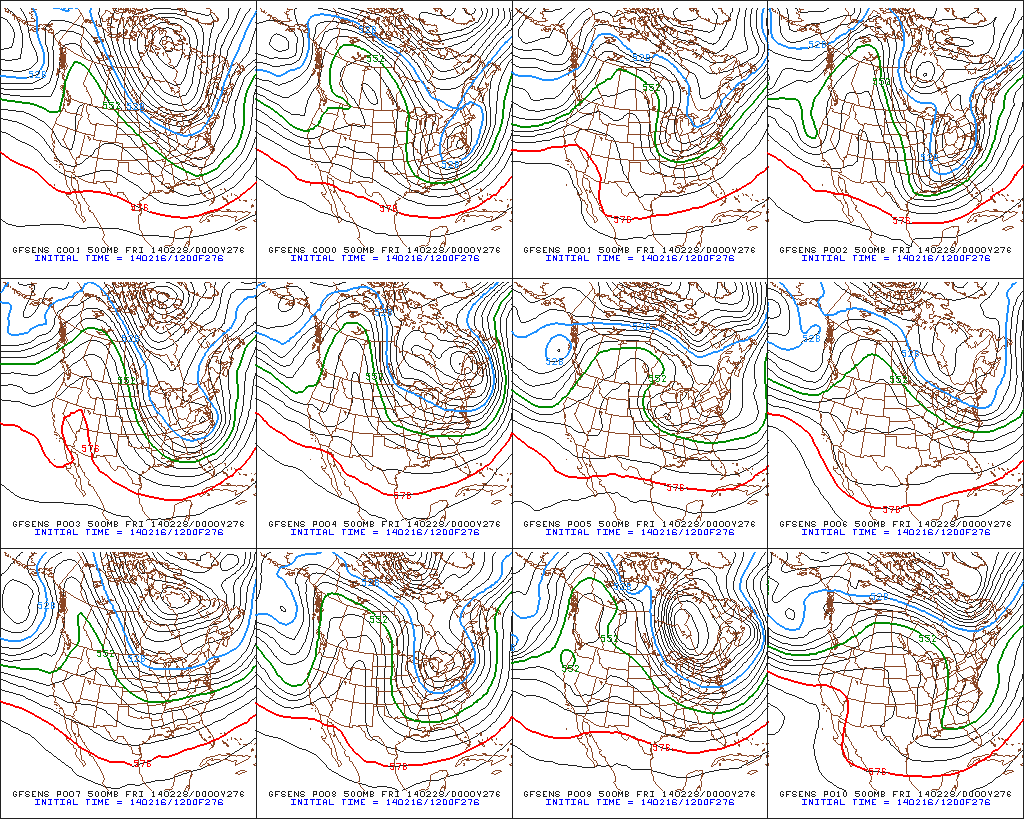
These weekend will feature mostly dry weather, with a gradual step down with temperatures. Next week still looks much colder with a threat of more snow.

Snowfall Map and Discussion for 2/18/14 Winter Storm


130am Snowfall map***Updated snowfall map, based latest guidance and observation and radar trends. It appears this system moving faster, and less snowfall will fall for areas NW of NYC. Still anyone visibilities may reduced to 1/4 mile for a couple hours, in heavy bands of snow.***

Cold high pressure will slide to the east tonight. Winds will turn more southeasterly. Temps will probably not drop much this evening and the may rise after midnight, near the coast. A 500mb shortwave will phases into closed low over Great Lakes region than open up as it heads east. At the surface, a small but robust area of low pressure will into Ontario and weaken. A secondary low will form near NJ/DE coasts and track into New England. This will set the area up for another moderate winter storm.

Precipitation with this system should arrive late tonight. There will be enough cold air in place, for everyone to start as accumulating snow. However, a  low-level southeast flow increases, enough warm air arrive to change coastal sections to rain or drizzle before ending tomorrow afternoon. Exactly when this happens and how snow fall before it, is problematic as mesocale models such as the NAM and RGEM are showing more liquid amounts than the global models. As they develop secondary low faster. Dynamics may also come into playing in keep boundary level temps cooler. The NAM model shows strong upward vertical velocities and mid-level instability (H5-7 lapse rates 7.1 C/km and total totals in upper 40s) that would result in band producing 2-3″ per  snowfall rates tomorrow morning with perhaps some thunder, before any changeover. The shortwave energy with system is also very potent. At this time, I will stay under the NAM’s totals. But if the NAM is correct, or the changeover is delayed, snowfall totals could be a few inches higher than on snowfall map.

namNE_500_avort_021Areas that see the least snowfall on the map, are south and east face shores that will most influenced by 15-30kt SE winds off the ocean and changeover to rain quickly. Just little farther inland over north side of NYC and north shore of LI snow will last longer, and come down moderate to heavy at times. Before changeover to rain and ending after 1-3 hours. Further NW in NNJ and theLower Hudson Valley, should remain mostly snow (perhaps ending as light rain and drizzle).

I might update this forecast map this evening or tonight, if more guidance comes in supporting a bigger/smaller snowfall. Tomorrow morning, I will be nowcasting here.

Cold & Stormy Late February into Early March

After some moderation with temperatures this week, the ECWMF, GFS and CMC ensembles are showing +PNA/West Coast Ridge for the last week of February. This will produce a mean trough over the Eastern US again with colder temperatures. Also note the Polar Vortex centered over Baffin Island:

12zECENS500mb12zGEFSf20412zCMCENS500mbf240The 8-14 day NAEFS shows 80-100% probabilities for below normal tempartures, for the Eastern half of the US:

NAEFS8-14dayPersistent warmer than normal sea-surface temperatures, have resulted in a resurgence of the ridge over Northeast Pacific region, since the fall. As of Feb 15th, the warm SST anomaly remains:

215sst.daily.anomThe latest ECMWF and GFS ensemble forecasts have the MJO going into phases 7 and 8 at end of this month. Which support the +PNA at end of this month into March.

ECMF_phase_MANOM_51m_fullNCPE_phase_21m_full

Currently analysis of 200mb vector wind anomalies show strong easterly jet over the Tropical Pacific. Which support the MJO propagation into phases 7 and 8.

current_anom_200windEvery time we’ve seen the -EPO/+PNA pattern reload, we seen a winter storm of at least moderate size. Models do show storms off and on, beginning next week. But the one that has most interested in is on Feb. 26-27th. The GFS and it ensembles have featuring this threat for possibly a Nor’easter. Several members show amplifying trough or closed low over the Eastern US, with a big ridge over the Northern Rockies.

12zGEFS500mbf276

12zGEFSslpf276To conclude, I think we are seeing the pattern cycle repeat itself, every few weeks, since November. However, the ensembles keep the Polar Vortex near Baffin Island. So while temps will average below normal, I don’t expect to see the extreme cold we saw back in January. There will be winter storms between the end of February and into first 10 days of March. But how large each of them will be for the area, will depend on the position +PNA/West Coast Ridge axis or the amount (if any) blocking on the Atlantic side.