Friday Storm 1/21

Next winter storm appears likely for Friday. The question is how huge will it be?

This depends how much phasing occurs with between northern and southern stream disturbance and how fast the trough amplifies before reaching the East coast.

The NAM,SREF, and GGEM have shown most amplified and phased out of all the models. They would bring a major snowstorm to parts of the area. There would also be some sleet or rain mixing in for some areas. However, their at 12z today, were bit less amplified, and showed a track a little farther east and faster. The GFS which appeared to be perhaps trending to more amplified solution, showed a flatter,and more progressive solution on the 12z run today. Which would give the area only light-moderate snowfall. The Euro continues to show weak system, with the most energy hanging back in SW.

Given the lack of upstream blocking, and the general unreliability of NAM,SREF,and GGEM at this range, a less amplified and progressive storm is more likely to me. However, with a huge 500mb ridge in the Pacific, the trough has plenty room to amplify before reach east coast. So I right now, I think this will be a moderate to a low end significant event for the tri-state area. More likely to be significant for areas north and east of NYC, then to the south and west.

I will post first call for snowfall on this storm tomorrow morning here. With further discussion on the latest model solutions. Then a final call sometime on Thursday.

Another post will also be coming this evening on a possibly larger winter storm threat next week!
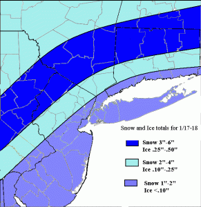
Snow and Ice Map for 1/17-18


Two areas of low pressure will affect us tonight and tomorrow. First one goes into Great Lakes. The second tracks east of tri-state area. There airmass over us will be cold enough initially for all precip to start as snow. But warm air intrusion, first aloft and then at surface, the snow will change over ice or rain for most areas.

Snow will arrive around midnight and then change to sleet and freezing and then plain rain along the coast tomorrow morning. Inland areas will see snow last longer before changing over to sleet and freezing rain during afternoon hours. A change to plain rain eventually is possible. But the cold air at surface is will tough to get rid, with the coastal low tracking east. Moderate snowfall and significant ice accumulations are likely for many inland areas N&W of NYC. The most being over the highest elevations. I used a blend of the warmer NAM and colder GFS bufkit soundings for snow and ice amounts.

Preliminary Snowfall Amounts for Friday’s Storm

Here is forecast map for snowfall amounts around the tristate:

http://img370.imageshack.us/img370/874/blankmapsf1.png

These are preliminary as there is still alot of inconsistency in models handle this storm. However, the trend has been in the last few days for a weaker and further east storm track. This will decrease precip amounts across the tri-state area, especially north and west of NYC. Snowfall amounts over 3″ appear unlikely this time. Precip types, may vary acros sthe area, as the storm tries to get better organized near us in the upper-levels. Soundings and Bufkit profiles show a warming layer at 900mb to 925mb. This may drag warmer air aloft to mix with or change snow to sleet, freezing rain, for some inland areas, Thurs night and Friday morning cutting down on snowfall amounts. Along coast, enough warm air should come to change the snow to sleet and rain before daybreak Friday. I used a blend of the GFS and GGEM QPF fields for this forecast (.25″ – .50″)

Back to tristateweather:

http://www.tristateweatherboard.com