70s on Saturday..Heavy Rain Monday… Unsettled Weather Through Next Week

Mostly sunny skies are expected today. But it will be not be as warm as than yesterday. With high pressure centered to the east, winds will be more out the east to southeast direction off the colder waters. High temperatures will reach the lower to middle 60s over inland areas. Upper 50s to lower 60s are more likely for high temperatures closer to coast. A weak shortwave trough advancing from the west will increase clouds tonight. Some scattered showers are likely around the area, late tonight and tomorrow morning.  Forcing and moisture is limited with this system. So rainfall amounts should be mainly on the light side. High temperatures are expected to be in the middle to upper 60s, with winds more out the southwest with cloud cover.

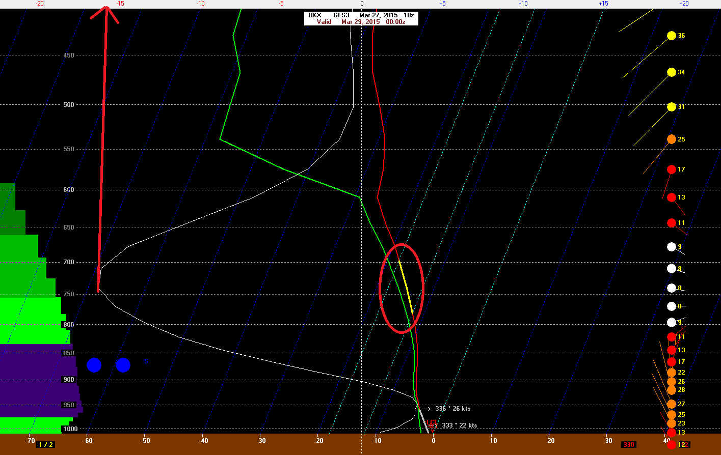
Yesterday’s temperatures reached the lower 70s. Despite northerly winds and 850mb temperatures of only 4C – 5C during the afternoon. This was due to a downsloping and a deep mixed-layer. Which caused the dewpoints to drop and more dry-adiabatic heating to occur. Model guidance has 850mb temperatures around +8C on Saturday afternoon with a west to northwest downslope flow. This mean high temperatures in the middle to upper 70s, across much of the area. It’s not out question some spots reach 80 degrees. The soundings actually show a deep-mixed layer above between 800mb-850mb, Saturday afternoon. Which often supports temperatures several degrees warmer than model guidance shows.

0z NAM showing widespread 70s over region on Saturday

High pressure will slide off the coast on Sunday. This will cause winds to turn more out of southeast off the cooler ocean. Temperatures will not be as warm as on Saturday. Highs will only reach the lower to middle 60s, away from the shore. Sunday will still be mostly sunny and dry as high pressure will remain in control.

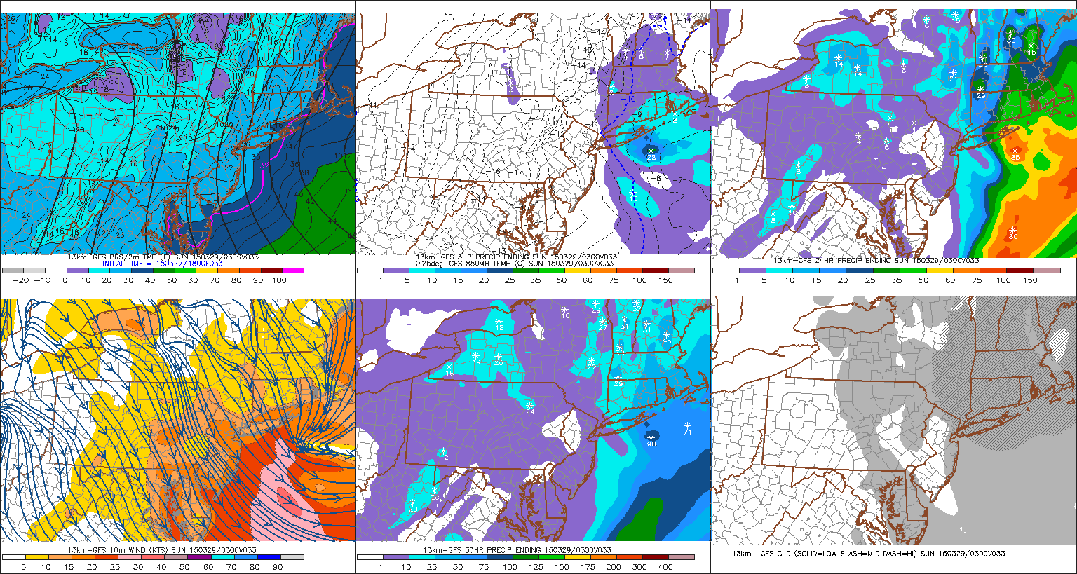
The northern and southern will phase into large upper-level low over Great Lakes region, early next week. A frontal system will move across the area on Monday. A strong southeasterly flow ahead of front, will bring moisture into the region. Model guidance is converging on a triple-point low developing along this front and a 40-50kt 850mb southerly jet moving across the area. These features will enhance more lift, moisture, and some elevated instability over the area on Monday. Precipitable water values between 1.00″ – 1.50″ support widespread rainfall totals over 1″. The pressure gradient between low and the high offshore could also gusts to 40mph, near the coast on Monday. With the new moon this weekend and early next week, this could result in some minor coastal flooding at high tides as well. We are talking about potential, at this point. These details will be fine tuned as we get closer to this event.

0z GFS showing 40-50kt 850mb jet over the Tri-state area on Monday

Unsettled weather pattern remains after this system, with the large upper-level closed low remains over Great Lakes and a ridge building over Hudson Bay and Davis Strait. A number systems may be coming around this low over the Eastern US. This means weather conditions are likely to vary from day to day. Dependent on timing, some days could still be warm and sunny Other days could be cooler and wetter. As often the case, we will have better idea on the weather each days, as we get closer/

0zGEFSf192

Cold and Damp Through Thursday…More Warmth and Thunderstorms Friday

Strong high pressure over SE Canada has cause a strong  cold front to push south into Mid-Atlantic region this evening. We call this a “backdoor cold front”, because it comes from the northeast or east direction instead of the more common northwest or west direction. Behind the fronts, is an ocean-cooled airmass. Temperatures have drop into 40s through the region, as east to northeast winds increase to 15mph to 20mph.  Periods of rain and drizzle have also developed around the region Tomorrow and Thursday will feature periods of rain and drizzle with temperatures in upper 30s to middle 40s through the region. Which 10 to 15 degrees below normal for this time of year.

18zNAMf24

High pressure will begin moving east into the Atlantic on Thursday night and Friday morning. This will cause stronger southerly flow and the front to lift back northward as warm front. Depending on timing and progression of this warm, temperatures could rise back into 60s or 70s in parts of the area. Especially over New Jersey and New York City. A low pressure system tracking into the Great Lakes will push a cold front through area on Friday night. Ahead of this front could some showers and thunderstorms for the Tri-state area late Friday afternoon. The Storm Prediction Center has placed Central and Southern New Jersey in a 15% slight risk for severe thunderstorms on Friday. Where is more likely to be unstable enough for some thunderstorms to reach severe levels.  However, there is some risk for some strong thunderstorms some shear and marginal instability. The main threats are strong winds and heavy rainfall.

day4prob

Behind the cold front, northwest winds will dry us out for a beautiful weekend. Saturday and Sunday will be mostly sunny and with high temperatures in the lower to middle 60s. Except upper 50s near the shores, where sea-breezes will develop late.

Snow Likely for Eastern Long Island and Southeast Connecticut Saturday

No we aren’t done with snow yet. Sometimes winter likes to linger into late March and even April.

An inverted trough with bands of snow will develop over New England and Long Island tomorrow afternoon and evening. This an elongated area of low pressure that extends from a larger storm developing well offshore. Upper-level shortwave energy enhances lifting and instability along this trough. Often there is narrow band of heavier snowfall associated with these troughs. The exact placement and intensity of the banding with these type of systems, are often difficult models to handle and these solutions vary from run to run. At this time it appears, that there is enough agreement to increase chances for accumulating snow tomorrow afternoon and even more so tomorrow night for parts of Long Island and New England.

18zGFSf33The latest run of the 18z GFS, shows a band of moderate to heavy snow falling over Eastern Long Island by tomorrow evening. The GFS sounding over OKX (Brookhaven, NY) shows significant omega values of up to -15 ub/s in snow growth region between 700mb and 800mb. Temperatures early tomorrow afternoon will be middle 30s. So initially some melting will occur, especially the roads and streets. However, after 4pm temperatures will fall into lower 30s and upper 20s as snowfall rates begin to increase and more cold air starts to advect in from the northwest. Snow should start accumulate on most surfaces at this point. At this time, a 1″ – 3″ snowfall looks most likely over Eastern Long Island and Southeast Connecticut. Localized snowfall totals between 3″ to 6″ are possible if heavier banding develops Saturday night. This will continued to be monitored and I will have another update tomorrow morning

18z GFS forecast sounding for Brookhaven, NY at 8pm Saturday

Elsewhere over tri-state some snow showers or flurries are possible tomorrow afternoon and early tomorrow evening..  These will not amount to much than some dustings or coating on the grass and colder surfaces. These areas will be too far away from the inverted trough. Some places west of New York City may not even see a flake. Snow will begin to end for Eastern Long Island and Southeast Connecticut, after midnight Saturday night. Sunday will become mostly sunny with high temperatures in upper 30s to lower 40s. As high pressure builds in from the west.