Tri-State Area Snowfall Forecast for 11/26/14 Nor’easter

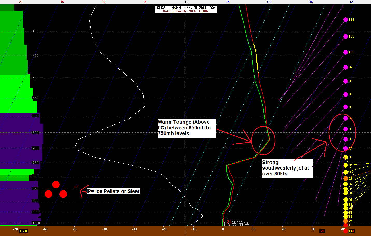
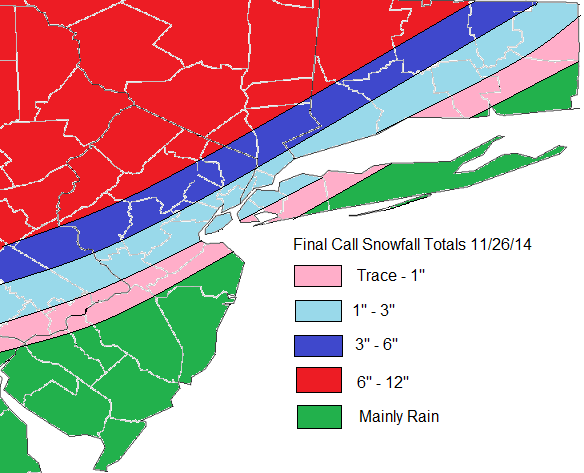
Latest models guidance has shifted track of this storm further west. Particularly the lows at 700mb, 850mb and surface levels. This will allow from more warm air-intrusion in mid-levels due a stronger southerly jet moving over more the area. Areas farther west farther west of I-95, will see rain or wintry mix change over to snow later this morning or early this afternoon. Which could fall heavy at times this afternoon or evening. Along I-95, include New York City metro area, rain should changeover to snow by early afternoon. But as this storm moves closer,  warmer air intrudes aloft. This cause snow to change to sleet for several hours this afternoon. This will significant reduce snowfall totals. Further SE, warmer boundary layer temperatures will precipitation mainly in form rain with perhaps a little snow or sleet mixed in at times. Winds out of the northeast increase will also increase this afternoon to between 15mph to 25mph with gusts to 35mph or 40mph near the coast. Then turn more north at same speeds this evening. Some minor tidal flooding is possible at high tides this evening along the north facing shores.

6z NAM showing closed 700mb with 60kt+ southwest winds over the coastal plain
6z NAM showing the 700mb closed to the west and 60kt+ southwest winds over the coastal plain
6z NAM sounding in the Bufkit at LaGuardia Airport, NY, at 1pm today
6z NAM forecast sounding 1pm today at LaGuardia Airport, NY
Final Call Snowfall map issued at 7am.
Mu Final Call for Snowfall total issued at 7am EST

Coastal Storm to Bring Heavy Rain and Winds to The Tri-State Area

Coastal storm is now taking shape along the East Coast. It’s weak, disorganized storm. But this system is pulling lots of moisture from the Atlantic and Gulf of Mexico. This will give parts of Tri-state area some heavy rainfall. A strong high east of New England will also create a tight pressure gradient between this system.  Resulting in windy conditions and some minor coastal flooding tomorrow as well. Check out more details below.

et0z3

Rainfall Totals:

There is some uncertainty, in how much rain will fall out this system. The model guidance is struggling with areas of convection off the east coast and some subsidence over Northeast. Right 1-2″ seems to be good bet for much the area. However amounts may vary greatly from area to area, depending on how heavy rain bands move through the area. Most guidance has good theta- advection and frontogensis with very high precipitable water values, lifting northward through the area late tonight and tomorrow. This is when heaviest rainfall will likely occur. Tomorrow afternoon these dynamics begin to weaken and lift northward. So some periods of lighter rain and drizzle is expected. This may linger into tomorrow night for Derek Jeter’s last home game at Yankee Stadium. But I think they will probably still play.

Rainfall Totals 092514

Winds & Coastal Flooding:

The low pressure with this storm is weak. But with a strong high east of New England, there will be a tight pressure gradient. This will cause winds out the east to northeast to increase between 25 to 35mph with gusts up 45mph,  along the New Jersey, Long Island and Connecticut shores. Just inland winds over NYC, Northeast NJ and Long Island will 15 to 25mph with gusts to 35mph. Further northwest winds will be weaker. With the new moon, these winds will cause some minor coastal flooding at high tides tonight and tomorrow morning. As well as some high waves and rip currents at the shore too. Buoy 44009 about 25 miles southeast of Cape May, NJ is already report waves up to 10ft this evening.

Wind Forecast 092514

New Snowfall Map for 3/02-3/03

FinalSnwofallmap0303

This morning’s 6z and 12z NAM, RGEM, GFS guidance today has trended further south this storm. The latest HRRR runs also supports this trend. Total qpf totals for Northern NYC are now in .10″ -. 25″ range. With less north and more south. Current radar, water vapor imagery, and observations, don’t give me much reason doubt these solutions. Also some warmer temperatures, may support more wet snow,sleet, rain at onset. Especially over Southern New Jersey. The cause for the continue trend further south, is the lobe of the PV, dropping down faster into Great Lakes and Northeast regions and suppressing this
southern stream wave.

Along with the south trend, is also a trend to end the storm faster everyone. For NNJ,NYC, LI snow may tapering off to flurries by sunrise tomorrow morning. While steadier snow continues further south into late morning or early afternoon hours tomorrow.

So for all those reasons, snowfall totals have been adjusted downward everywhere. And it’s possible this is still too high for some areas. Just to note, the ranges in general, are from lowest to highest; from north to south. For example: Staten Island, is more likely to see 3″ or 4″ than 5″ or 6″. While Philadelphia is likely to see at or either side close to 6″.