2/13/14 Nor’easter Snowfall Wed PM Update

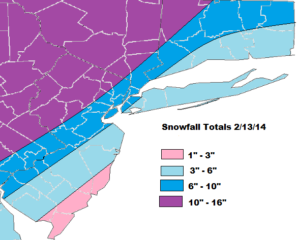
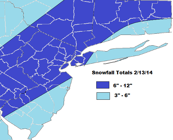
New snowfall map is below. The model guidance has shifted the track surface and mid-level lows further west. This means more warm air likely be able work inland. So heaviest snowfall will be falling just north and west of I-95 corridor. Snowfall basically to come two waves:

1. As warm air tries to surge in, a TROWL/strong coastal front, will be developing late tonight. Models are strong vertical velocities tomorrow morning. That could result in snowfall rates 1-3″ per hour. Some thunder and lightning is not out of the question either. After these bands move through, many coastal areas will either changeover to sleet, rain or drizzle.

2. CCB (cold-conveyor belt) will be developing later tomorrow, as the storm bombs out near out latitude. Model guidance is tracking the storm over Eastern/Central LI. So the CCB will likely be stronger with more significant additional accumulations for Western sections of the area. While Eastern areas may pickup additional 1-2″. This will have monitored closely tomorrow.

SnowfallmapWed

Nor’easter likely for Wednesday night and Thursday 2/13/14

Guidance has coming into consensus for a major storm along the East Coast, Wednesday night and Thursday.  The main questions are the exact track and intensity of this storm. Cold high pressure will be sliding offshore of New England on Wednesday night. This means support for cold air to remain place will be weakening, ahead of this storm. If the storm takes track too close to coast, coastal sections will likely changeover to sleet and rain and less snowfall. While heavy snow continues further inland. However, if this storm intensifies rapidly and tracks just far east, they may only be a brief mix or changeover for the coast, before going back to heavy snow.

Features that need to be watched over the next 24hrs:

1. The low coming in Midwest (the kicker). The timing, strength, and placement of this low can have  number of impacts on the east coast storm.  This system, if stronger and faster, could lead to slower development of the storm or further east track

2. The 500mb low. The sooner this low closes off, the slower, stronger, and farther west this storm will be. A closed 500mb low to south or east, is favorable for major snowstorm for the tri-state area.

3. The 700mb and 850mb lows. Where these features track are important for frontogenesis and cold-conveyor belt formation in our area. Heavier snow is favored anywhere to north and west of these lows. While more warm air or dry air intrusion, favored to south and east.

Much of the guidance today shows these mid-level lows closing off and track from Delmarva NE to Southern New England. This should put the heaviest snowfall from I-95 major cities N&W. Further S&E will snow see more sleet, rain, and dry air decreasing snowfall totals. The preliminary snowfall total map is below:

Besides snow, this storm may have other minor or moderate impacts. Such has high winds gusts to 40mph and minor tidal flooding along the coast:
Image

New Winter Storm to Affect the Area Tonight and Wednesday

Active pattern continues. Unlike Monday’s storm, this bring more of a mix of wintry precipitation. Snow and ice forecast is below this discussion.

Low pressure will track into Ohio Valley tonight. Strong, cold high pressure over Queebec, will force this low weaken and transfer south of Long Island. With cold air place tonight, everyone will see snow at the onset. However, enough warm air is expected to surge aloft, for a mix or changeover to sleet and freezing rain by sunrise. During the day tomorrow, sleet and freezing rain should to rain for all coastal sections. While inland areas could see more snow, sleet and freezing continuing throughout the day.

Despite strong high pressure and cold-air damming, the 850mb and 925mb lows are tracking near the OH/PA border. This forces warm to eventually surge into mid-levels. At the same time, we seeing more where more frontogenetic forcing  The models show strong 500-700mb vertical velocities, entering the tri-state area tonight. This will enhance snowfall rates to 1 inch per hour and keeping the column cooler, for several hours. Any delay in the changeover, will result in higher snowfall totals for that area.

gfsNE_500_vvel_024gfsNE_850_temp_024

Snow will mix with sleet than changeover to sleet and freezing rain for NYC and coastal sections between 4am – 7am.  Inland areas the changeover will take longer. Icing will significant for inland areas. This will to treacherous driving and might be enough bring down tree branches and power lines. I will update these forecasts if guidance or observations warrant: But a severe, widespread damaging ice storm is not expected.

I will update this maps, tonight or tomorrow. If new guidance or observations warrant.  There’s also another storm  brewing for this weekend or early next week. I will discuss that more as we get closer.

Snowfallmap

Icemap2414