Based on latest guidance and observations. I’ll discuss more soon:
Based on latest guidance and observations. I’ll discuss more soon:
This is a forecast discussion is for the NYC-PHL Tri-State area.
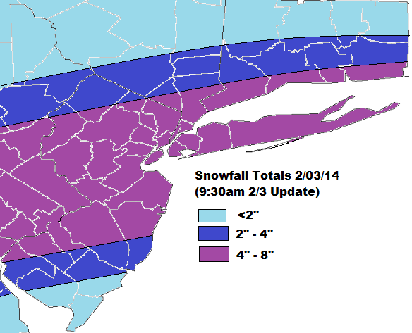
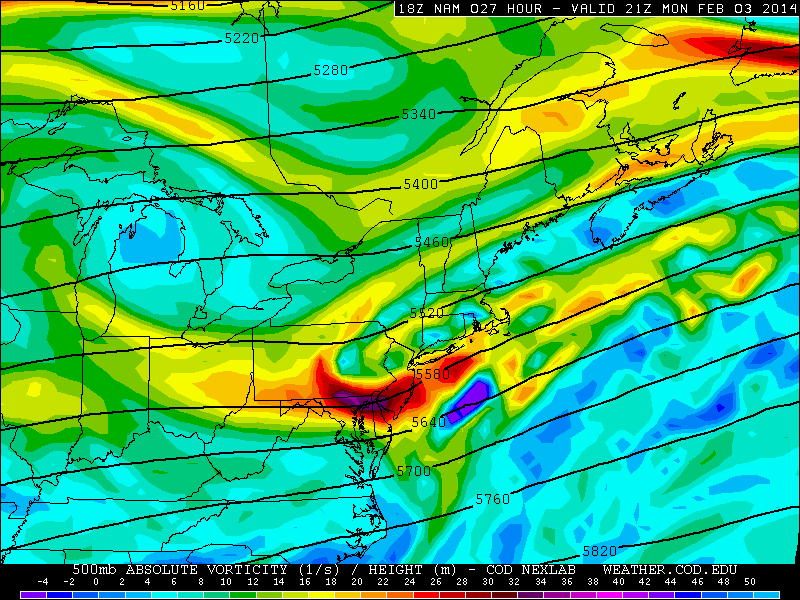
A cold front will move across the region tonight, with some rain showers. Then a wave of low pressure will track up front offshore. As it turns it colder rain showers will change over to snow showers and become steadier and heavier tomorrow morning. Snowfall could be falling at the 1″-2″ per hr. Especially over Parts of NJ, NYC and LI. Snow should begin to taper off and end late Monday afternoon.
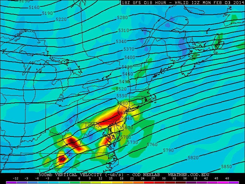
Models have the best UVVs going over parts of SE PA and CNJ tomorrow. This where I’m predicting highest snowfall total Extreme SNJ/DE will have more warm to overcome tomorrow morning.
 QPF totals on the models and ensembles range anywhere from .50″ to 1.00″ the area, expect farthest northern suburbs. It’s possible these totals too high, due progressive moving on the storm. But this system unlike past system, this system in picking more moisture out the Gulf.
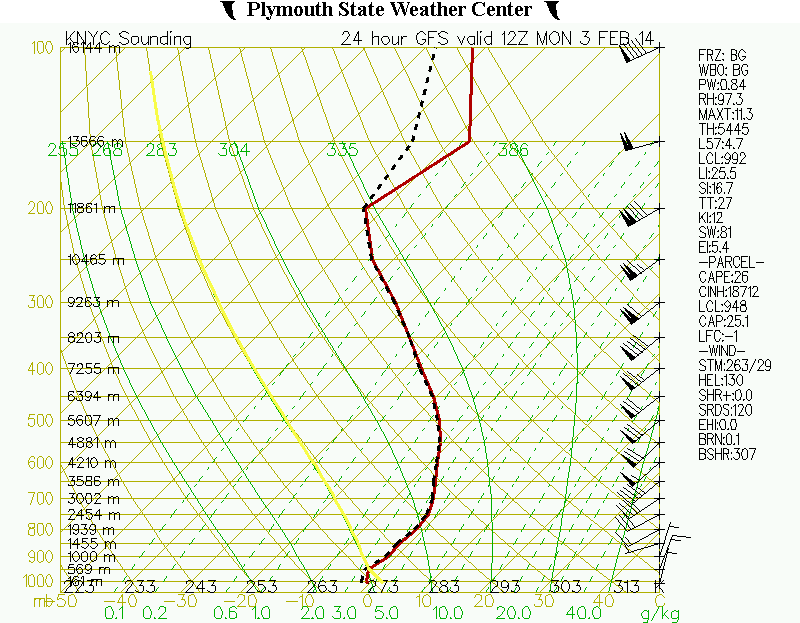
The main concern here is with temperatures. Especially in the boundary layer. Today many places around NYC where in low and mid 50s. Several degrees higher than guidance suggested. If the column doesn’t cool off as fast as modeled, early tomorrow morning, than snowfall totals will be less than predicted.
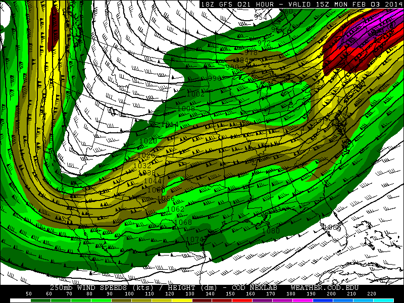
 On the other hand, if this farther north with stronger forcing, we could see higher totals, more dynamic cooling and heavier precip. We are right-rear exit region of a 250mb upper-level streak. 500mb vorticity has all trending stronger today on all the models. So this isn’t out of the question.
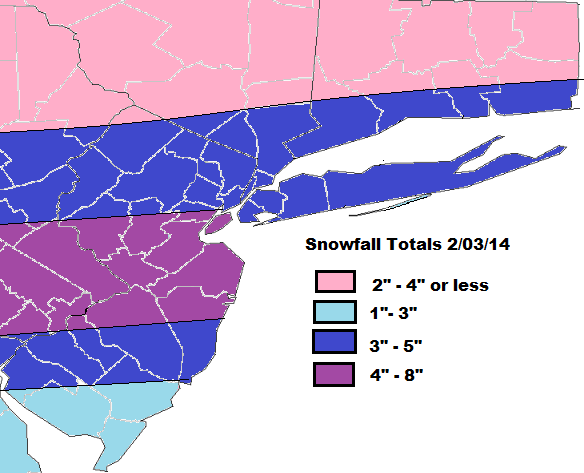
Here’s is the snowfall total forecast:
Next winter storm appears likely for Friday. The question is how huge will it be?
This depends how much phasing occurs with between northern and southern stream disturbance and how fast the trough amplifies before reaching the East coast.
The NAM,SREF, and GGEM have shown most amplified and phased out of all the models. They would bring a major snowstorm to parts of the area. There would also be some sleet or rain mixing in for some areas. However, their at 12z today, were bit less amplified, and showed a track a little farther east and faster. The GFS which appeared to be perhaps trending to more amplified solution, showed a flatter,and more progressive solution on the 12z run today. Which would give the area only light-moderate snowfall. The Euro continues to show weak system, with the most energy hanging back in SW.
Given the lack of upstream blocking, and the general unreliability of NAM,SREF,and GGEM at this range, a less amplified and progressive storm is more likely to me. However, with a huge 500mb ridge in the Pacific, the trough has plenty room to amplify before reach east coast. So I right now, I think this will be a moderate to a low end significant event for the tri-state area. More likely to be significant for areas north and east of NYC, then to the south and west.
I will post first call for snowfall on this storm tomorrow morning here. With further discussion on the latest model solutions. Then a final call sometime on Thursday.
Another post will also be coming this evening on a possibly larger winter storm threat next week!
