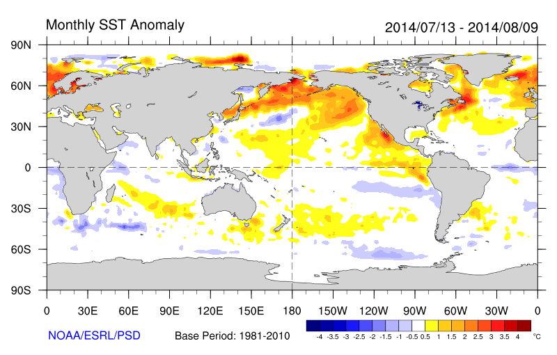
Warmer than normal sea-surface temperatures over Northern Pacific Ocean also known as +PDO (Pacific Decadal Oscilliation), have enhanced ridge over heights over West Coast of North America from time to time. This was has resulted in troughiness over Eastern North America, with virtually no prolonged or extreme heat this summer for Northeast United States. In fact, temperatures have been near or below normal for the last several weeks:
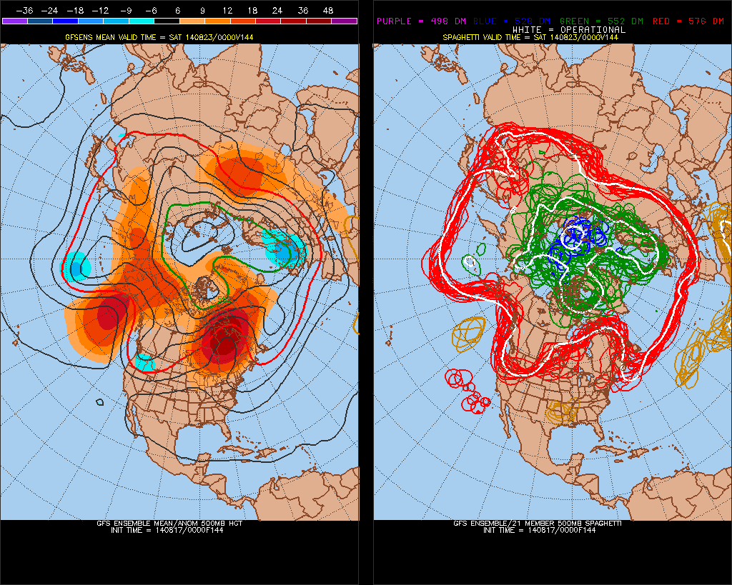
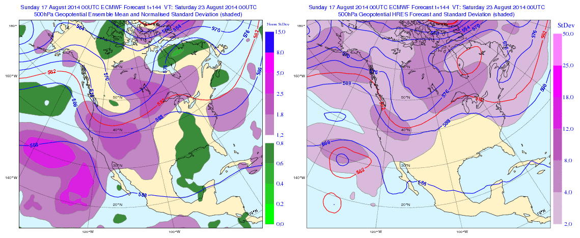
Continuing this theme, the GFS and ECMWF ensemble means for later this week shows at 500mb, shows a Northeast Pacific ridge with heights extending up to Alaska and trough digging into Pacific Northwest. This is a classic -EPO/-PNA pattern. This results in ridge building over Central United States. But the amplification of this ridge into Hudson Bay/Southeast Canada, leads to lower heights over the parts of the East Coast/Western Atlantic. Somewhat reminiscent of an omega block. This supports disturbances to drop down from the north or an onshore flow with high pressure to the north and east:
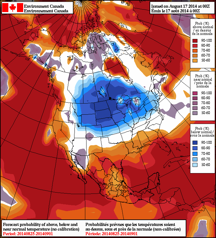
The trough over the Western US will eventually shift eastward, after this period. A brief surge warmth and humidity, may proceed it. But another cooler airmass will likely come behind it. Overnight guidance is starting to pick up on this as well. The 8-14 day outlook from the NAEFS, basically last week of August, now showing 50%> probabilities of temperatures averaging below normal from over the Northern Plains into the Northeast:
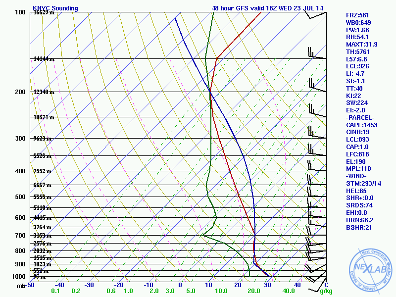
After a decent weekend and beautiful day today, warmer and humid airmass will start to return to the Tri-State area tomorrow. As southwesterly flow develop throughout the day. High temperatures will reach the middle to upper 80s, away from the south-facing coasts with dewpoints in middle to upper 60s. An isolated shower or thunderstorm is possible with daytime heating and instability. Wednesday will be even more humid with high temperatures in the upper 80s to lower 90s. There is a better chance of showers and thunderstorms with a cold front moving through region late in afternoon or evening. NAM and GFS forecast sounding show with 1000-2000 J/kg MLCAPE 500-700mb lapse rates 6.5 C/km to 7.0 C/km. Which supports some thunderstorms to become strong or severe, with strong winds and large hail. However weak shear values suggest thunderstorms will pulse up and down.
GFS Model forecast sounding for NYC at 18z (2pm ET) Wednesday. MLCAPE 1434 J/kg, L57 6.8 C/km and weak directional shear support pulse strong to severe thunderstorms.
After this cold front, pass a slightly cooler and less humid airmass will once again be over region for the rest of the week. High temperatures will be in the lower to middle 80s with sunshine. More humidity and thunderstorms may return again, on Sunday as another frontal system approaching the region. However, the big story this summer seems to be lack of extreme or prolonged heat waves. This has been due to the reloading of strong ridge over NE Pacific or West Coast causing more troughs to dig into East. Long-range guidance continues to show this pattern continuing for the next couple of weeks, at least.
So far, this Spring in the Tri-State Area, we have seen more cooler weather, dominate and warmer periods more transient. Last week was another example with Tuesday and Wednesday will very cool, with east winds bringing marine air off the ocean. While Thursday we saw temperatures warm into middle to upper 70s, away from immediate coast. According to a tweet from the National Weather Service in Upton, NY, January to April 2014 averaged below normal for Central Park. The last four-month period to do that,was from April to July 2003. Later this week, looks like more swings with temperature, with the warm front position each day very important. So when will the warmth be here to stay for good?
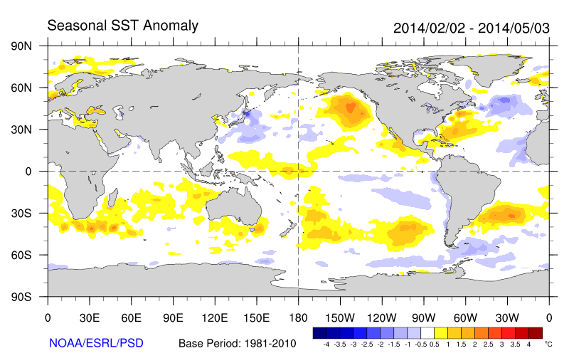
First we need too look at what has been causing all this huge swings temperatures. The first, most persistent feature, are the above normal sea-surface temperatures in the Northeast Pacific. This enhances a stronger ridge over parts Northeast Pacific Basin, usually ahead of deep trough or low positioned near the Aleutian Islands. This pattern is known as EPO (Eastern Pacific Oscillation), in its negative phase. This is a feature that has been there, since the late fall of 2013.
Persistent pool of warm SST anomalies over the Northeast Pacific Ocean
The -EPO ridge often shifts east into West Coast of North America. However, with the lack of sustained blocking on the Atlantic side the pattern remains somewhat progressive. The -EPO ridge shifts east into west coast of North America transforming into +PNA pattern. Then when the next Pacific storm moves in Aleutians/Bering Sea, the -EPO ridge reloads with enhancement from the warm sea-surface temperatures over the Northeast Pacific.
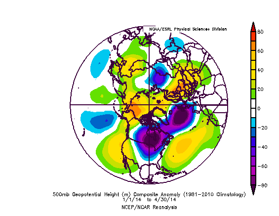
500mb mean height anomalies from January-April 2014 showing an -EPO pattern dominating over North America
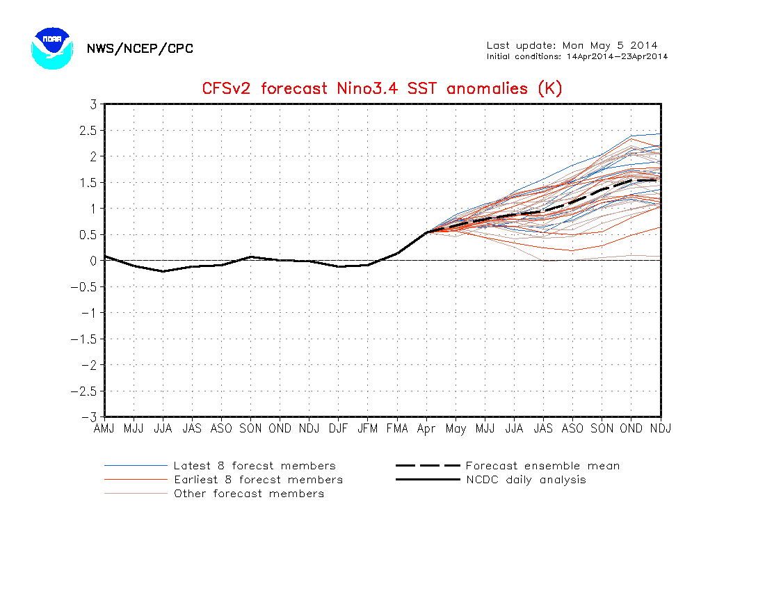
A moderate to strong, El Nino is forecast later this summer. The means we are likely looking at a warm East Pacific Chances are this warm SST anomaly will also persist through the summer and beyond. So the -EPO likely won’t be going away for good, anytime in the near future.
CFSv2 ensemble forecasting sea-surface anomalies +1K to +2K for Nino 3.4 region
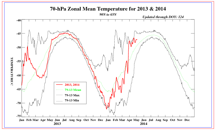
Warmer than average temperatures over also in the lower stratosphere has supported the -AO/-NAO blocking to develop. This has resulted keeping deeper trough over SE Canada or the Northeast for much of this Spring. Although there has been a tendency for the -AO/-NAO blocking to be transient, because there has been a parade of Pacific storms crashing into West Coast. So were not able to lock cooler than normal pattern over the Eastern CONUS either. Instead, we see more volatility with huge swings in temperature.
70mb temps in lower stratosphere running above average, late March/early April
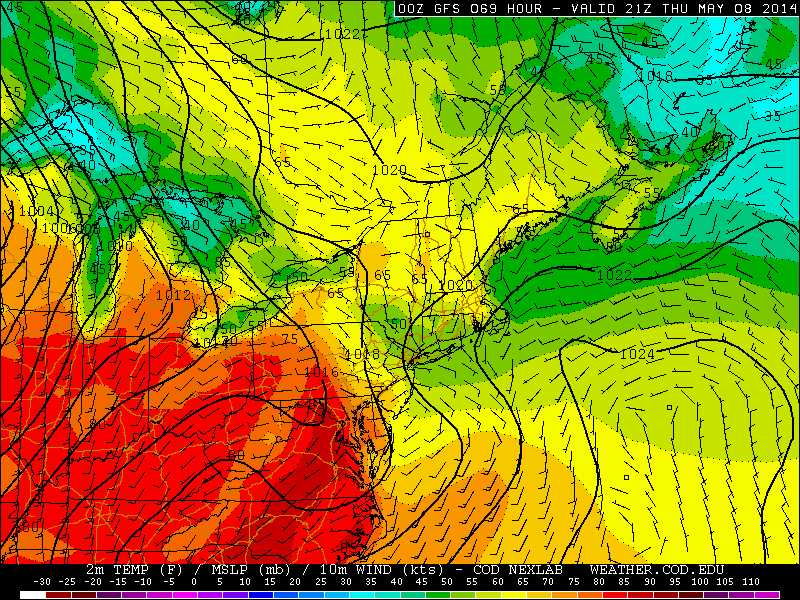
The models show the AO/NAO rising next two weeks. So that will allow the for another intense, warm surge late this week for Eastern US. However, models now trending stronger with trough over SE Canada. This trough will produce confluence or high pressure over New England and likely force the warm front to stall to our south on Thursday. Keep most of the area in cool, marine airmass with chance of a showers.
GFS showing the warm front remaining south of the Tri-State area on Thursday. Temperatures in 50s over Northern New Jersey, New York City, and Long Island.
The trough will start shifting east on Friday. Allowing the warm to make more progress northward. We could see big difference in temperatures and sky conditions from SW to NE across the area. More widespread 70 or 80 degree temperatures are more likely this weekend. With a little more sunshine and showers and thunderstorms more widely scattered.
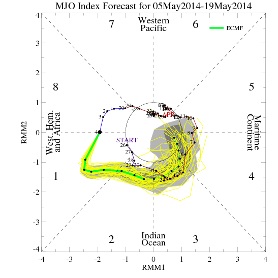
The MJO is now active and will be propagating into phase 2 next week. Which supports another period cooler and wetter weather over the Eastern US, sometime between May 15- 20th period. Beyond that, MJO might get into phases 5 and 6. Which supports longer period of above normal temperatures for much of Central and Eastern CONUS for late this month. With El Nino growing the summer, the MJO is likely to be more active and have some influence on our weather pattern.
15-day ECMWF ensemble forecast for MJO propagate into phase 2 next week.
As we go later in Spring and Summer, the cold impacts of -EPO/-AO/-NAO gradaully decrease. The supply of cold air begins to run out. The configuration morphs into a pattern that supports warmer west-down slope flow in our region. So will probably warm periods will last longer. However, we still have monitor for troughs over SE Canada or New England to force warm front to stall south of region or to push backdoor cold front in our region. Until mechanisms producing -EPO/-AO/-NAO patterns from to time start to change.
 The trough over the Western US will eventually shift eastward, after this period. A brief surge warmth and humidity, may proceed it. But another cooler airmass will likely come behind it. Overnight guidance is starting to pick up on this as well. The 8-14 day outlook from the NAEFS, basically last week of August, now showing 50%> probabilities of temperatures averaging below normal from over the Northern Plains into the Northeast: