Humidity & T-Storms Return Briefly by Wednesday

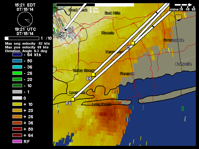
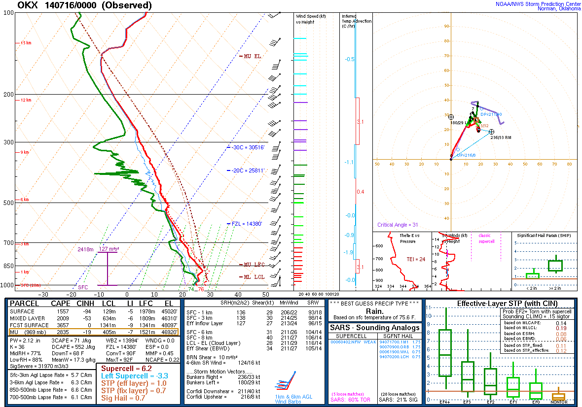
After a decent weekend and beautiful day today, warmer and humid airmass will start to return to the Tri-State area tomorrow. As southwesterly flow develop throughout the day. High temperatures will reach the middle to upper 80s, away from the south-facing coasts with dewpoints in middle to upper 60s. An isolated shower or thunderstorm is possible with daytime heating and instability. Wednesday will be even more humid with high temperatures in the upper 80s to lower 90s. There is a better chance of showers and thunderstorms with a cold front moving through region late in afternoon or evening. NAM and GFS forecast sounding show with  1000-2000 J/kg MLCAPE 500-700mb lapse rates 6.5 C/km to 7.0 C/km. Which supports some thunderstorms to become strong or severe, with strong winds and large hail. However weak shear values suggest thunderstorms will pulse up and down.

GFS Model forecast sounding for NYC at 18z (2pm ET) Wednesday. MLCAPE 1434 J/kg, L57 6.8 C/km and weak directional shear support pulse severe thunderstorms.
 GFS Model forecast sounding for NYC at 18z (2pm ET) Wednesday. MLCAPE 1434 J/kg, L57 6.8 C/km and weak directional shear support pulse strong to severe thunderstorms. 

After this cold front, pass a slightly cooler and less humid airmass will once again be over region for the rest of the week. High temperatures will be in the lower to middle 80s with sunshine. More humidity and thunderstorms may return again, on Sunday as another frontal system approaching the region. However, the big story this summer seems to be lack of extreme or prolonged heat waves.  This has been due to the reloading of strong ridge over NE Pacific or West Coast causing more troughs to dig into East. Long-range guidance continues to show this pattern continuing for the next couple of weeks, at least.

Severe Thunderstorms Hit Long Island 7/15/14

This past week, we had a storm event, wasn’t a big severe weather or tornado outbreak that was being suggested by other sources for Northeast and Mid-Atlantic regions. But there were some severe thunderstorms for a parts of the area. These are base velocity radar images from thunderstorms that hit Long Beach and and Jones Beach in Long Island, New York. These storms produced wind gusts up to 60mph near Point Lookout, knocking down trees over parts Nassau and Suffolk Counties. Heavy rainfall from these t-storms also caused localized flash flooding.

Image courtesy of Weather Underground.
Base Velocity loop showing strong winds, courtesy of Weather Underground.

It’s not a relative common occurrence, for severe thunderstorms on Long Island. As the marine layer from a wind direction off the ocean waters, tends to cause thunderstorms to collapse as they approach the coast. However, on Tuesday a cap was present and winds were out southwest direction (over more land). Which allowed more instability to develop, with some sunshine. The  sounding below, is from a balloon launch Tuesday evening, from the National Weather Service office in Upton, NY showed 2009 J/kg of MLCAPE (mixed-layer cape). That is high amount of buoyancy in the lowest 100mb layer for this area. This instability also was juxtaposed with 31kts of 0-6km shear and 29kts of 0-1km shear. Which contributed to more organized and stronger updrafts and downdrafts in thunderstorms.

OKX Sounding from balloon launch at 8pm Tuesday 7/15/14
OKX Sounding from balloon launch at 8pm Tuesday 7/15/14 

Quick Update on Severe Wx Threat Today

Some new developments since my earlier post this morning. SPC has upped damaging wind probabilities from 15% to 30% for New York City, New Jersey, Eastern PA and the Lower Hudson Valley. Probabilities for large hail and tornadoes remain lower and unchanged: day1probotlk_1300_wind The 12z OKX sounding from a balloon launch by the National Weather Service, showed a cap inversion layer around 900mb. Also a 500-850mb lapse rate of 6.4 C/km and 37kts of 0-6km bulk shear . As a result, with enough sunshine, we will be able to destabilize at faster pace than yesterday. Before more forcing arrives to overcome that cap. Hence the forecast SBCAPE  at 2016 J/kg (click on image to see clearer): OKXAlso, the threat for isolated tornadoes increases. For example, the 12z HRRR from the College of Dupage website shows also 2500 J/kg- 3000 J/kg SBCAPE with low-level winds backing to SE late this afternoon over NE NJ/NYC area, These parameters combined along with low LCL and high helicity results in significant tornado parameter greater than 3.0 over that area. Which is very substantial for the local area: hrrrNEsf_con_stp_009This may not played out as precisely as this models shows. But the potential is worth monitoring today. I might have other updates through the day today, if there are major changes or new developments.