Possible Tornado in Southern NJ… More Flooding and Severe T-Storms Likely Today

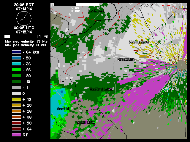
Yesterday t-storms produce mostly heavy rains with only some widely scattered reports of damage or strong winds. However, radar detected strong rotation and winds with thunderstorm over near Permberton,NJ last night around 8:30pm. A storm chaser on twitter took this picture of a possible tornado that hit near that town. A weak low forming yesterday over Southern NJ, enhanced low-level directional shear that may of produced tornado. The National Weather Service will likely go out and survey the area today. I may have another  post about it, when the survey is completed. Update: NWS confirms straight-line winds. No tornado.

Base velocity radar loop show strong rotation with winds 75kts aloft near Perbermton, NJ (courtesy of Weather Underground)

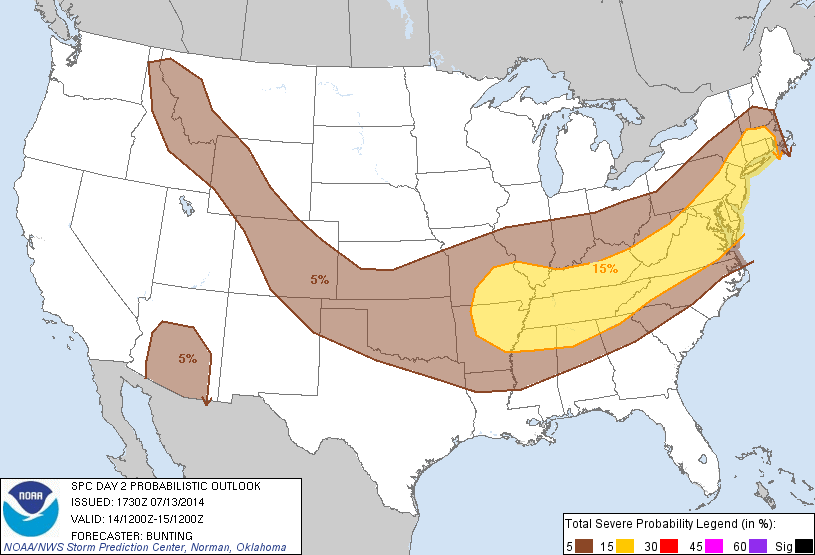
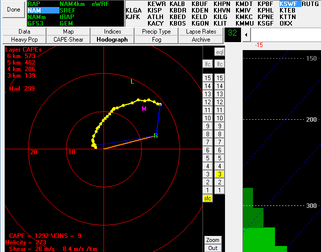
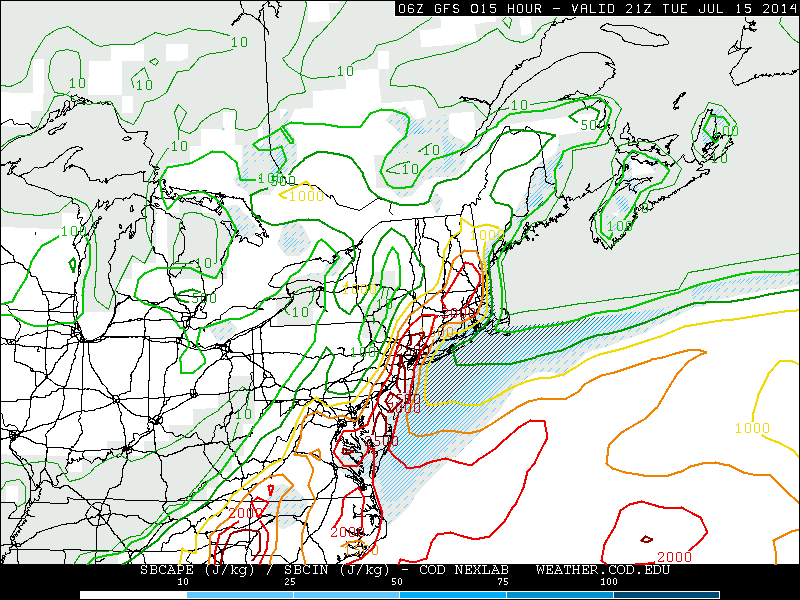
Meanwhile, the Storm Prediction Center has slight risk for the entire tri-state area again today. In my last post I discussed, that the severe weather threat may be reduced today with more showers and thunderstorms through the day, keeping instability lower. However, models still show moderate instability with SBCAPE values 1500 J/kg to 2500 J/kg and liifted Index values between -3 and -6, by this afternoon. 0-6km bulk shear is also 30kt to 40kts this afternoon.  Those parameters support organized severe thunderstorms, in some locations. Especially over NYC, New Jersey, the Lower Hudson Valley . A southerly wind off the water, will likely keep parts of LI and South CT less unstable. Damaging winds from thunderstorms are still biggest severe weather threat. However, cold upper-level low a little closer to area to today,  the threat for large hail is little higher than yesterday. Model soundings also indicate a backing of low-level flow this afternoon. So an isolated weak tornado cannot be ruled out.

Today's 6z run of the GFS, showing SBCAPE values between over 1500 J/kg - 2500 j/kg over the tri-state area. (image courtesy of College of Dupage)
Today’s 6z run of the GFS, showing SBCAPE values between over 1500 J/kg – 2500 j/kg over much of the NYC Tri-state area (image courtesy of College of Dupage)

The National Weather Service has also issued a flash flood watch for the entire area. Flooding still appears to be bigger threat than severe weather, as only marginal instability is needed for t-storms with heavy rainfall this afternoon and evening. With precipitable water values near 2.00″ any storm produce between 1″ – 3″ of rainfall in short period of time, resulting in flooding of poor drainage areas or small rivers and streams. Showers and thunderstorms will likely continue overnight and into Wednesday morning, as the cold front with system, slowly moves through the area. With the of loss diurnal heating, instability will diminish. So the threat for more severe thunderstorms will be over. But threat for heavy rainfall will continue. After the cold front passes, clouds will likely break for sunshine tomorrow afternoon. Sunshine, low humidity and seasonable temperatures are expected for Thursday and Friday.

Severe Weather & Flooding Threats Monday & Tuesday 7/14- 7/15

An anomalous cold closed upper-level low swinging over the Great Lakes, will cause another period of stormy weather early this week, in Northeast and Mid-Atlantic. A deep southwesterly  flow ahead of this system, will provide moisture feed out the Gulf of Mexico and Atlantic. The Storm Prediction Center has again issued a slight risk for the local tri-state area on Monday. That means they are anticipating some organized severe thunderstorms. But not widespread in coverage and violent in intensity.

SPC 1730 UTC outlook with 15% risk of severe thunderstorms on Monday
Today’s SPC 1730 UTC outlook with 15% risk of severe thunderstorms on Monday.


The main threat, from any of these storms Monday will be flash flooding, damaging winds Large hail is possible. But poor mid-level lapse rates and high freezing levels shown on model forecast soundings, will keep this threat lower. A warm frontal boundary will develop over the local region on Monday. This will cause winds the low-level winds to back from south-southeast at the surface to southwest aloft. For areas near the coast, including NYC, there will be more of marine influence that may keep thunderstorms under severe levels. But areas further inland, may heightened risk for isolated weak tornado. Especially over the Lower Hudson Valley.

Hodograph on the 12z NAM model with strong directional shear and significant CAPE over Newburgh, NY
Hodograph on the 12z NAM model with strong directional shear and significant CAPE over Newburgh, NY Monday evening

On Tuesday, as the upper-level low moves further east, shear and lifting will increase. Without much capping in the atmosphere, showers and thunderstorms could be more widespread and frequent through the area. But this may also act to keep instability lower across the area for thunderstorms to become severe. Flash flooding is likely to be a bigger threat.  Very high precipitable water values and some unidirectional shear will causes thunderstorms to train and produce torrential downpours in parts of the area. Stay tuned for another update tomorrow for this threat.


Tropical Storm Arthur, Heat & T-Storms Wed. & Thurs.

First tropical storm of the Atlantic Hurricane Season, Arthur was born today, from a disturbance that was previously discussed off the Southeast US coast.  Weaker northerly shear allowed thunderstorms organized more over the center. As of the 11pm advisory from the National Hurricane Center, Arthur has maximum sustained winds of 50mph and is pm;u drifting northward. However, very cold cloud tops near the center, seen on satellite imagery this evening, indicate that Arthur continues to get better organized and might start intensification trend soon.

1115zrbtop0

Most model guidance shows Arthur strengthening to a hurricane as it moves north-northeast near or over the outer banks of North Carolina. That area could some heavy rain and strong winds. Although, since this is lop-sided system with drier air to northwest, hurricane force wind will likely be in southeast quadrant. Then the storm will track out into the open Atlantic, well southeast of the Tri-State Area. However, Arthur will be in  right-entrance region of strong upper-level jet streak, enhancing an band of rainfall over local tri-state area during day on Friday (July 4th). Some rough surf may occur at the beaches. The rain start moving out by Friday evening. Perhaps just in time for fireworks festivities. This weekend is look beautiful with mostly sunny skies and temperatures in middle to upper 80s.

Before that we are looking at more heat and humidity to continue through at Wednesday for tri-state area. High temperatures on Wednesday will likely get between in low or middle 90s for NE NJ and NYC, with sea-breezes keeping more coastal areas slightly cooler. There is also a chance of some  afternoon thunderstorms, with a pre-frontal trough over region. Some thunderstorms may be locally severe with amount of surface-based instability shown of the guidance. However, bulk shear is little low for thunderstorms to remain well organized. So I’m not expecting widespread severe weather. Some thunderstorms may also produce some very heavy rainfall. Thursday looks wetter with cold front and upper-level streak closer,with  scattered showers and thunderstorms all day. Some thunderstorms may train and cause flash flooding.