Warm, Humid & Storms Today. More Rain & Storms Possible Wednesday Night & Thursday

With a southerly flow, today will be warmer and more humid for Tri-State area. Temperatures will rise into middle to upper 80s this afternoon, away from the coast. Scattered showers and thunderstorms will develop along trough axis approach from the west this afternoon. Best chances for showers and thunderstorm will be north and west of New York City, where lift and instability will be higher. Model forecast soundings show sufficient SBCAPE for thunderstorms to become strong this afternoon. However, weak vertical shear and poor mid-level lapse rates will limit storm organization and intensity. Also with the weak flow and PWAT near 1.80″, any thunderstorms will be moving slowly and capable of producing very heavy rainfall. Which could result in some flash flooding. Showers and thunderstorms should gradually diminish tonight. As the trough axis shifts east and instability decreases after sunset.

6z NAM model sounding for Trenton, NJ late this afternoon, for high SBCAPE, weak shear & pwat 1.77"
6z NAM model sounding for Trenton, NJ late this afternoon, for high SBCAPE, weak shear & pwat 1.77″

Tomorrow we will see more sunshine. But it will not be as warm and humid. A weak cold front will slowly pass through the area. Temperatures will still take run at 80 or above, with a deep NW flow and steepening lapse rates. A strong cap aloft will likely suppress shower and thunderstorm development during the afternoon and early evening hours.

6z NAM showing strong capping inversion tomorrow
6z NAM model sounding showing strong capping inversion tomorrow

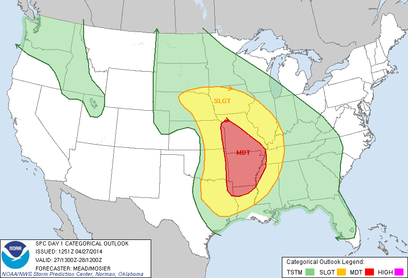
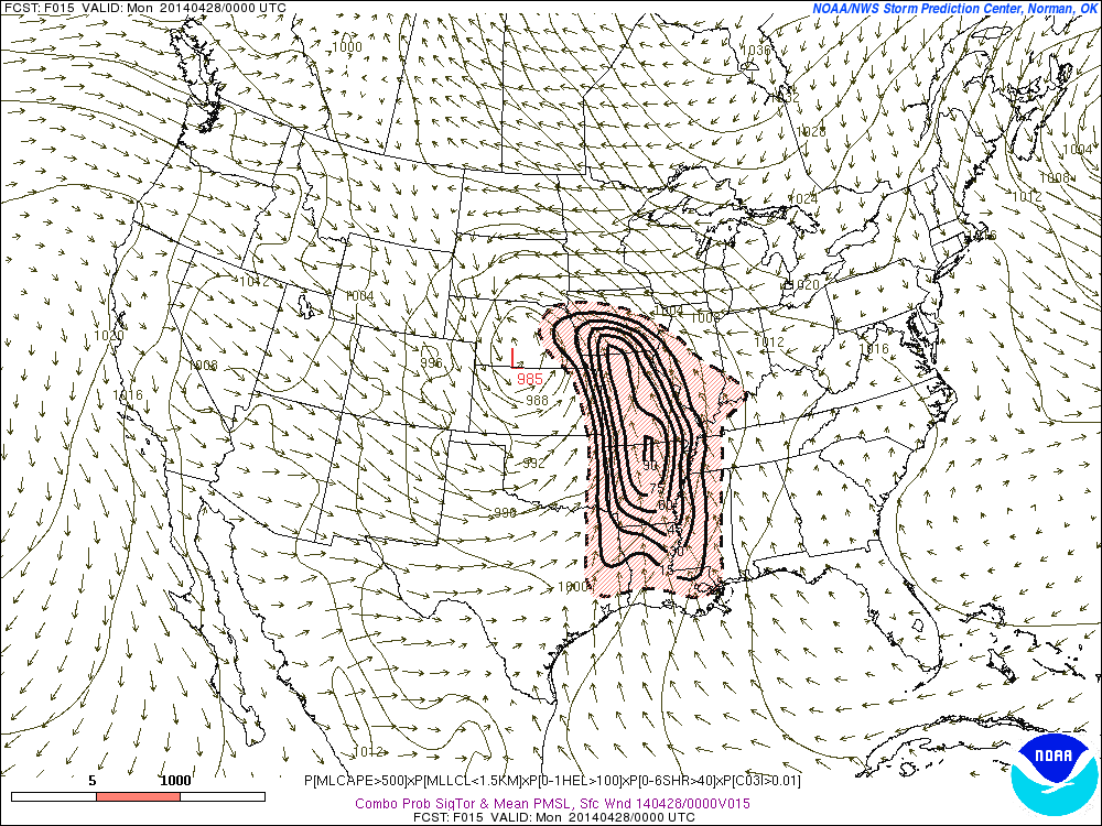
Later tomorrow night into Thursday could get more stormy. A potent shortwave and wave low of pressure that will producing severe weather over Central Plains today and Ohio Valley tomorrow, will moving across our region. There are some models differences on the exact timing and track of this wave through our area. If this wave, tracks over Central or Southern New Jersey, it could give many of us period of heavy rain with embedded, elevated thunderstorms. A track further north than that, would put more of the in warmer, unstable airmass and vertical wind shear. Which would support strong to severe thunderstorms. At this time, much the guidance favors the southern track. But as the begins develop over Central Plains today, this could still be some changes. Stay tuned for another update late tonight or early tomorrow.

Severe Wx Outbreak to the West Today and Tomorrow

A strong storm and upper-level low taking a negative tilt will cause severe t-storms with potential of producing straight-line damaging winds, large hail and tornadoes are parts Central Plains and Mississippi River Valley. At this time, the storm prediction center in Norman, Oklahoma, has place much the area in moderate risk. However an upgrade to a high risk is possible later today:

day1otlk_1300Curved low-level and mid-level jet streaks at over 50kts, will be providing directional shear and forcing. Surface dewpoints in the 60s and 70s, steepening lapse rates and high CAPE (convective available potential energy), will provide ample moisture and instability. Large, curved hodographs on the forecast models, also show potential for some strong tornadoes to form. Latest SREF at 9z today, has moderate and to high probabilities for ingredients for signficant tornadoes over large parts of Central and Lower Mississippi Valleys

SREF_prob_combined_sigtor__f015This severe wx outbreak like spread east into parts Ohio Valley and Tennessee Valley, later tonight and tomorrow. As this storm system and upper-level low begins to slowly move east. The threat for strong tornadoes will continue to exist. Slight risk and moderate risk have been issued by SPC:

day2otlk_0600

Mild Today, Rain Wednesday, Bitter Cold Thursday

In my last post, I discussed hot the models where show temping the low and middle 50s. Temperatures actually soared into 60s today in many with west downslope winds. JFK set new record at 65. Beautiful late winter day to enjoy some outdoor activities. Tonight will see increasing clouds late with temperatures falling into upper 30s inland and lower 40s for the coast.

With this very mild airmass in place, the storm for Wednesday has trended warmer, deeper and further northwest. It now appears this will be a mostly rain event for even parts of Hudson Valley and Interior CT.  If fact, these could steadier and heaviest rainfall. Many of us will be in warm sector, with periods of light rain and drizzle with temperatures rising into 50s over NYC and lower 60s over Central and Southern NJ.  A strong 500mb shortwave and cold front, likely to produce a forced low-topped squall with some gusty winds later tomorrow afternoon or evening. With some elevated instability in the form steep mid-level lapse rates,TTs in the 50s and MUCAPE, some elevated thunderstorms are also likely. Any surface-based instability will be based on any clearing that takes place, tomorrow afternoon. This will enhance the threat for isolated severe wind gusts. Most-likely south and west of NYC.

12zNAMf3912zNAMrad36Behind this cold front, it will turn windy with temperatures will rapidly fall back into 20s and teens later tomorrow night. Any wet roadways could see some black ice form. Some snow showers that could coat the ground, are also possible with the upper-level trough with swinging through tomorrow night. Especially north and west of NYC.  Thursday will be big change from the last few days. It will be windy with temperatures only slowly climbing out of the teens into lower 20s. This arctic blast will not last longer, however. After a cold Friday morning, temperatures will rise into upper 30s and lower 40s in the afternoon.