Coastal Storm to Bring Heavy Rain and Winds to The Tri-State Area

Coastal storm is now taking shape along the East Coast. It’s weak, disorganized storm. But this system is pulling lots of moisture from the Atlantic and Gulf of Mexico. This will give parts of Tri-state area some heavy rainfall. A strong high east of New England will also create a tight pressure gradient between this system.  Resulting in windy conditions and some minor coastal flooding tomorrow as well. Check out more details below.

et0z3

Rainfall Totals:

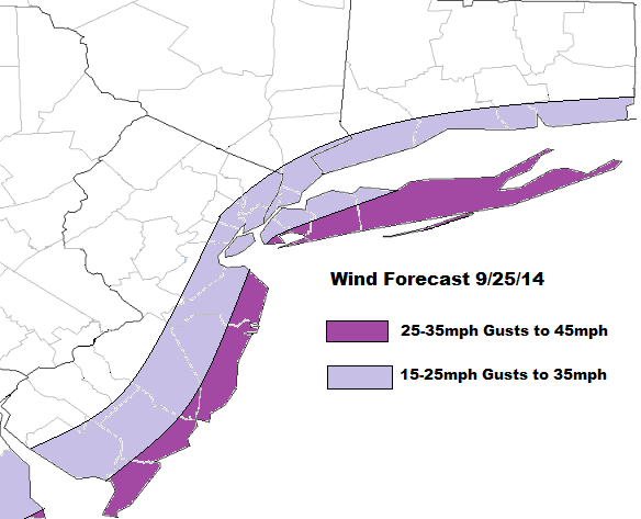
There is some uncertainty, in how much rain will fall out this system. The model guidance is struggling with areas of convection off the east coast and some subsidence over Northeast. Right 1-2″ seems to be good bet for much the area. However amounts may vary greatly from area to area, depending on how heavy rain bands move through the area. Most guidance has good theta- advection and frontogensis with very high precipitable water values, lifting northward through the area late tonight and tomorrow. This is when heaviest rainfall will likely occur. Tomorrow afternoon these dynamics begin to weaken and lift northward. So some periods of lighter rain and drizzle is expected. This may linger into tomorrow night for Derek Jeter’s last home game at Yankee Stadium. But I think they will probably still play.

Rainfall Totals 092514

Winds & Coastal Flooding:

The low pressure with this storm is weak. But with a strong high east of New England, there will be a tight pressure gradient. This will cause winds out the east to northeast to increase between 25 to 35mph with gusts up 45mph,  along the New Jersey, Long Island and Connecticut shores. Just inland winds over NYC, Northeast NJ and Long Island will 15 to 25mph with gusts to 35mph. Further northwest winds will be weaker. With the new moon, these winds will cause some minor coastal flooding at high tides tonight and tomorrow morning. As well as some high waves and rip currents at the shore too. Buoy 44009 about 25 miles southeast of Cape May, NJ is already report waves up to 10ft this evening.

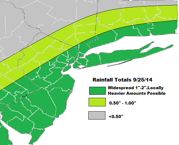
Wind Forecast 092514

Significant Coastal Storm Possible Wednesday Night and Thursday

High pressure will be over East today. Bringing party sunny skies. With light onshore winds highs temperatures will only be upper 60s to near 70 today. Enjoy because the weather make take turn for the worst starting tomorrow night.

This high pressure will begin to weaken and slide east into Nova Scotia on Wednesday. This will allow low pressure developing off the Southeast US, to track northward up the Mid-Atlantic coast. There are some differences in the guidance in how they handling this system. But the overall trend past three runs has been further north. Clouds will likely increase on Wednesday, with some rain overspreading the area from north to south Wednesday night and into Thursday.

A few things to watch here, before I hone in on details. First, how strong is subsidence or high pressure will be in this area. This will be a factor in how rainfall we receive. Most guidance seems to show heavy band of rain making as for north as Central New Jersey before weakening. Although this morning’s 6z GFS and it’s ensembles have coming with an even wetter solution.  Sea-surface temperatures off the east running warmer than normal. This may enhance more deepening of coastal storm than what models show. As was seen with Sunday’s coastal storm that was a near miss for the Tri-state area.

6z GFS from overnight showing coastal storm over Delmarva with rain over the Tri-State area. Wettest soultion
6z GFS from overnight showing coastal storm over Delmarva with heavy rainfall over the Tri-State area. Wettest solution

There will also be tight pressure gradient developing with strong high pressure north of this low. This could cause winds out the east to northeast to increase near the coast Wednesday night How strong these winds be in the area will depend on the intensity and track of the low. Some high surf and rip currents are likely over the ocean. There will also be new moon on Thursday. So minor coastal flooding at high tides is possible. I will have more updates and details here are coming as new guidance comes today.

This storm will begin to weaken and drift slowly away from the Tri-state area later Thursday afternoon. Leaving behind perhaps a few some scattered light showers for the Derek Jerek’s last home game at Yankee Stadium night. Friday and this weekend are looking better  with high pressure building back over the Central and Eastern US. Temperatures will begin moderate to above normal. Perhaps near 80 degrees, away from the coast.

Warmer & Humid Tomorrow with PM T-Storms

A warm front move through the area tomorrow morning with some clouds. Winds turn more southwesterly south of this front, transporting a much warmer and humid airmass.  Temperatures over New York City and much of New Jersey will rise into the middle to upper 80s. However, this will be short-lived as a cold front will moving through the area tomorrow evening with some scattered showers and thunderstorms.

The 12z NAM models showing 80s for highs over much of NJ and NYC, with southwest winds. Then some showers or thunderstorms for the northwest.

The Storm Prediction Center had issued a slight risk early this morning for these t-storms tomorrow. This was mainly in the warm sector, when instability is more likely to support severe thunderstorms. However, this afternoon look as removed the slight risk entirely. Regardless of what SPC issues, there are some factors going against widespread severe weather. Mid-level lapse rates are poor with a mostly west to southwest flow aloft. While 0-3km helicity values are in 150 m2/s2 to 200 ms/s2 late tomorrow, 0-6km bulk shear is between 25kt to 30kts with 500mb winds a little weak in the area. Clouds in the warm sector also an issue with getting more extreme CAPE values. Some models show SBCAPE near 1000 J/kg over Central and Northern New Jersey. But MLCAPE and NCAPE values are lower. This suggests CAPE will be skinny and will not support very tall updrafts. Southeast winds or sea-brezzes ahead of the warm may also keeps parts of Long Island and NJ shore, in more stable airmass. Which supports thunderstorms to weaken in this area. All this considered, I think will any severe weather will be very low and isolated. Some t-storms might strong enough produce wind gusts near 40mph. There is also very small possibility of very weak spinups (tornadoes) along the warm front nearby). But without more instability, this threat is not heightened here. Models do show very high precipitable water values over 2.20″. So any thunderstorm will be capable produce some very heavy rainfall with flash flooding in poor drainage areas.

12z NAM today precipitable water values over 2.20"+
12z NAM today precipitable water values over 2.20″+

Showers and thunderstorms will taper off later tomorrow night and clearing will take place late. A cooler and less humid airmass is in store starting on Friday. High temperatures will only reach the lower to middle 70s, despite alot of sun. Some uncertainty continues over the weekend as models stall this cold just off the Mid-Atlantic coast on Sunday. Then move a number of waves north up this frontal boundary through early next week. Details will be fine tuned as we get closer.