Cold Temperatures This Morning Giveway to A Gradual Warming Trend

Overnight skies cleared and winds calmed lightened. This allowed temperatures to drop into upper 20s and lower 30s in the suburbs and a freeze to occur. Closer to New York City, temperatures dropped into middle to upper 30s. This cold airmass is impressive for this time of year. However, it’s not unprecedented. We were several degrees above most record low temperatures for this period. The only exception is new a record low this at Islip, NY. Which records only go back to 1982.

RECORD EVENT REPORT
NATIONAL WEATHER SERVICE NEW YORK NY
0747 AM EDT SAT APR 25 2015

…RECORD LOW TEMPERATURE SET AT ISLIP NY THIS MORNING…

A RECORD LOW TEMPERATURE OF 32 DEGREES WAS SET AT ISLIP NY AT
344 AM. THIS BREAKS THE PREVIOUS RECORD OF 36 SET IN 2012.

Low temperatures overnight in the Tri-State area
Temperatures(F) early this morning in the Tri-State area

Temperatures are expected in to climb into upper 50s to lower 60s with mostly sunny skies this afternoon. Which is still several degrees below normal for this time of year. But warmer than then the past two days. A low-pressure system tracking well to our south may be bring more clouds tonight. Especially over Central and Southern New Jersey. However any rainfall is expected stay south of the Tri-State area. Any clouds around early tomorrow morning should break for some sunshine. High temperatures on Sunday afternoon are expected be in upper 50s to lower 60s again. A gradual warming trend should continue into middle of next week with closer to normal temperatures. A couple of disturbances with a cold pool aloft, might cause some widely-scattered showers during the afternoon hours on Monday. Otherwise, fair weather is expected with highs further into 60s on Monday and Tuesday. On Wednesday, increasing mid-level heights and downsloping winds could cause temperatures to rising into upper 60s to around 70 on Wednesday with plenty of sunshine. These temperatures are closer to normal this time of year.

The GFS showing temperatures in the middle to upper 60s on Wednesday with wsw winds and sunshine
The GFS model showing temperatures in the middle to upper 60s on Wednesday with west-southwest winds winds and partly sunny skies

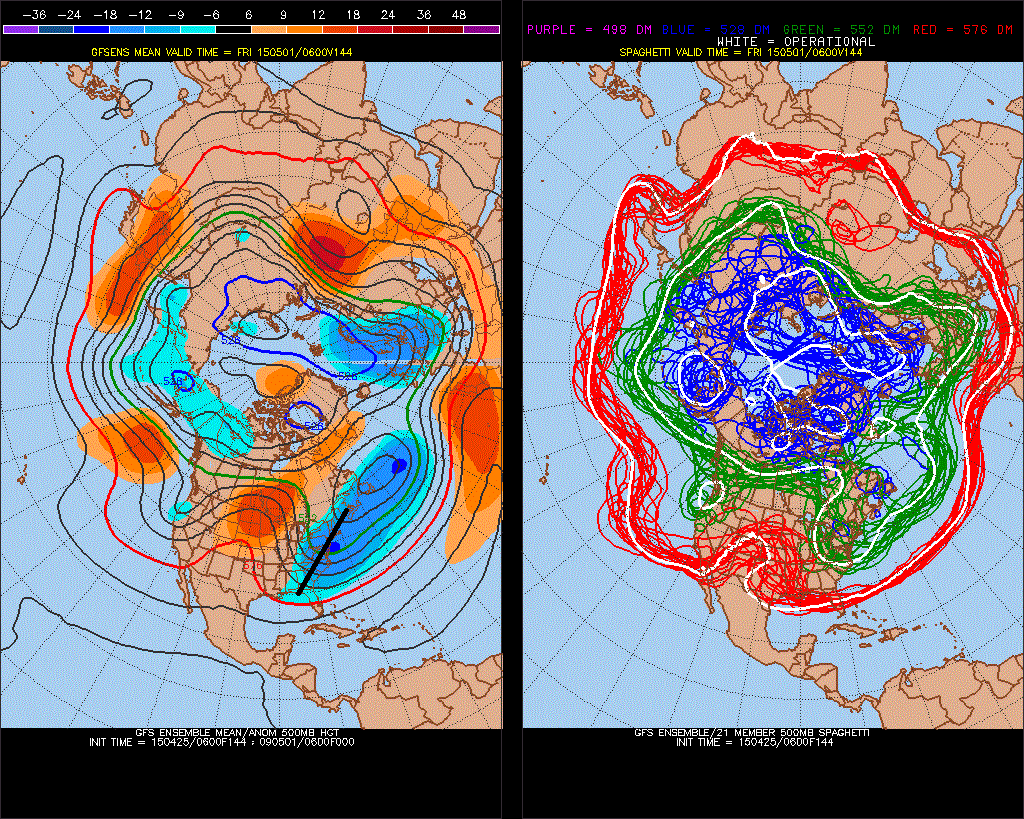
Later in the week, the weather looks little more muddled with possibly another upper-level low over region causing some widely scattered showers. Temperatures are still likely to reach the 60s. There was some concern that storm developing over Southeast United States, would come up further up the coast and impact the Tri-State region late this week. This was due to the some high-latitude blocking and ridge amplification over Western US. causing the northern and southern streams to phase. Current model trend now show this storm going out into Atlantic, well south and east of region. The blocking pattern is weaker and the ridge shifts east more into Central US. The result is a more positively-tilted trough over the Eastern and less phasing. However, I will still monitor this storm. Stay tuned for more updates over the next several, in case there are any major changes.


6z GEFS showing the ridge over Central US with positive-tilted trough over East Coast. This keeps the storm over Southeast US from coming further north.
This morning’s GFS ensemble showing the ridge over the Central US with a positively-tilted trough over the East Coast.This keeps the storm over Southeast US from coming further north.

Heavy Rain & Thunderstorm Threat Monday

After a beautiful weekend, that featured the first 80 degree weather for local area. Some nasty weather is on the way for tomorrow. Fortunately, this storm is just a nuisance for the most part. Still some details for you to be prepared for:

Rainfall:  As a warm front with with a wave low approaches, rain will slowly overspread from the southwest the late tonight. A 50kt+ southeasterly low-level jet and a plume of sub-tropical of moisture will provide ample lift and moisture rain to be heavy at times, during the morning and early afternoon hours on Monday. Forecast sounding show a stable airmass during this time frame. So thunderstorms are not expected. Rain will taper off later in the afternoon. As the best forcing with low-level jet starts to shift northeast of the Tri-State area.  A cold front may cause a few more showers and thunderstorms tomorrow night. A widespread 1.00″- 1.50″ of rainfall is expected late tonight and tomorrow with locally heavier amounts possible. Some ponding of water in typical poor-drainage or low-lying areas is possible. However, with lack of any significant rainfall recently, more serious flash or river flooding is not anticipated.

Winds: 850mb winds will be running between 50-60kts tomorrow morning and early afternoon. A stable airmass does not support these winds to mix down. However, there could be wind gusts between 30mph and 40mph with the rainfall. Especially near the coast. Also any thunderstorm will be capable of producing stronger wind gusts tomorrow night with the cold front. This is discussed more in the severe weather section below.

18z GFS showing precipitable water values over 1.2"-1.5" over the area tomorrow morning.
18z GFS showing precipitable water values over 1.2″-1.5″ over the area tomorrow morning.

Tidal flooding. With the new moon this weekend and  the east to southeast flow tomorrow, there could be some minor coastal flooding at high tides tomorrow. Particularly around New York Harbor, the south shores of Long Island and the New Jersey shore. Tides could be 1 to 1 1/2 feet above normal.

Severe Weather: The storm prediction center has issued marginal and slight risks for severe thunderstorms. A cold front associated with this system will move across the area tomorrow night.  A deeper southwesterly flow just above the surface, will generate more elevated instability, ahead of this front. More rainfall from more scattered showers and isolated thunderstorms will possible tomorrow night. Any thunderstorm will capable producing heavy rain and gusty winds. But are unlikely to reach severe levels with the warm front remaining south of NYC. Over parts of Central and Southern New Jersey some clearing may take place later tomorrow afternoon. This could atmosphere to destabilize further for stronger thunderstorms with isolated damaging wind gusts.

70s on Saturday..Heavy Rain Monday… Unsettled Weather Through Next Week

Mostly sunny skies are expected today. But it will be not be as warm as than yesterday. With high pressure centered to the east, winds will be more out the east to southeast direction off the colder waters. High temperatures will reach the lower to middle 60s over inland areas. Upper 50s to lower 60s are more likely for high temperatures closer to coast. A weak shortwave trough advancing from the west will increase clouds tonight. Some scattered showers are likely around the area, late tonight and tomorrow morning.  Forcing and moisture is limited with this system. So rainfall amounts should be mainly on the light side. High temperatures are expected to be in the middle to upper 60s, with winds more out the southwest with cloud cover.

Yesterday’s temperatures reached the lower 70s. Despite northerly winds and 850mb temperatures of only 4C – 5C during the afternoon. This was due to a downsloping and a deep mixed-layer. Which caused the dewpoints to drop and more dry-adiabatic heating to occur. Model guidance has 850mb temperatures around +8C on Saturday afternoon with a west to northwest downslope flow. This mean high temperatures in the middle to upper 70s, across much of the area. It’s not out question some spots reach 80 degrees. The soundings actually show a deep-mixed layer above between 800mb-850mb, Saturday afternoon. Which often supports temperatures several degrees warmer than model guidance shows.

0z NAM showing widespread 70s over region on Saturday

High pressure will slide off the coast on Sunday. This will cause winds to turn more out of southeast off the cooler ocean. Temperatures will not be as warm as on Saturday. Highs will only reach the lower to middle 60s, away from the shore. Sunday will still be mostly sunny and dry as high pressure will remain in control.

The northern and southern will phase into large upper-level low over Great Lakes region, early next week. A frontal system will move across the area on Monday. A strong southeasterly flow ahead of front, will bring moisture into the region. Model guidance is converging on a triple-point low developing along this front and a 40-50kt 850mb southerly jet moving across the area. These features will enhance more lift, moisture, and some elevated instability over the area on Monday. Precipitable water values between 1.00″ – 1.50″ support widespread rainfall totals over 1″. The pressure gradient between low and the high offshore could also gusts to 40mph, near the coast on Monday. With the new moon this weekend and early next week, this could result in some minor coastal flooding at high tides as well. We are talking about potential, at this point. These details will be fine tuned as we get closer to this event.

0z GFS showing 40-50kt 850mb jet over the Tri-state area on Monday

Unsettled weather pattern remains after this system, with the large upper-level closed low remains over Great Lakes and a ridge building over Hudson Bay and Davis Strait. A number systems may be coming around this low over the Eastern US. This means weather conditions are likely to vary from day to day. Dependent on timing, some days could still be warm and sunny Other days could be cooler and wetter. As often the case, we will have better idea on the weather each days, as we get closer/

0zGEFSf192