Tropical Update 9/14/14: Edouard Out to Sea, Hurricane Odile Threatens Baja California

8:35am 9/14 Update: Odile is now major Cat 4 hurricane with 135mph winds. Another post coming later today.

Just another update on the tropics both in the Atlantic and East Pacific

Tropical Storm Edouard is about 1000 miles east-northeast of the Leeward Islands. Edouard has intensified with current maximum sustained winds at 65mph and has turned to the northwest at 14mph. All model guidance continues show to Edouard recurving into open North Atlantic over next 4 to 5 days. Perhaps becoming a Category 2 or 3 hurricane, as it continues to move over warm sea-surface temperatures and more favorable upper-level environment.

rbtop0

aal06_2014091400_track_early

Invest 92L is now the Gulf of Mexico. But has become less organized with low-level center less defined and lack of convection. Strong northeasterly wind shear and dry air intrusion is now expected to prevent further development of this disturbance.Convection has diminished with Invest 93L in the East Atlantic. Dry, sinking air around this disturbance, is now likely to prevent further development.

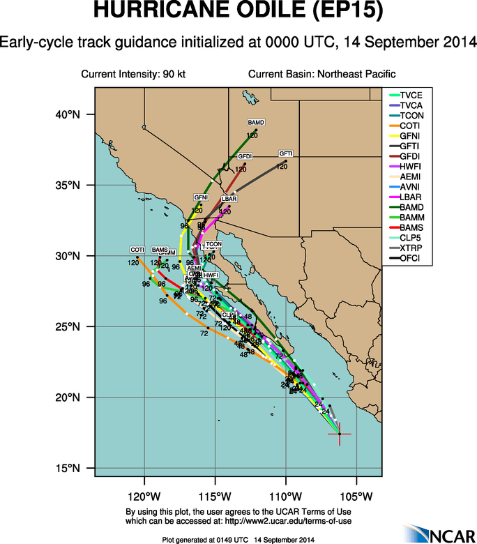
Without any threats in Atlantic, our attention turns to East Pacific again. Hurricane Odile is rapidly strengthening and is now a major threat to Baja California. As of the 8pm PDT advisory from the National Hurricane Center, Odile is moving to north-northwest at 12mph with maximum sustained winds at 110mph. Making a strong catergory 2 hurricane. It’s is forecast to become a major category 3 hurricane and track very close to the west of southern Baja California, late on Sunday and Monday. Hurricane warnings have issued for the region, including Cabo San Lucas. It is possible Odile could become even stronger and track even further north and east over the southern Baja Peninsula. After Monday, Odile is expected continue to track north-northwest just west over the central Baja California and gradually weaken to a tropical depression as it moves over cooler waters. Some model guidance also take remnants of Odile into parts of Northern Baja Peninsula and the Southwest US later next week. All interests in the Baja Pennisula should keep an eye on Odile this week. People in the hurricane warned and watched areas should take immediate precautions.

rbtop0

8pm PDT Track

aep15_2014091400_track_early

Tropical Update: Edouard & Invests 92L & 93L

Hurricane Season has relatively quiet so far. The main reason are that the subtropical high has been stronger parts of Central and Eastern Atlantic this year. This causes stronger easterly shear and more dust off Africa . Which inhibits more developing tropical waves moving Africa coast. Stronger high over East Atlantic, also  allow more troughs or upper-level lows persist over Western Atlantic. Which cause more shear and dry air or tropical systems to recurve out to sea. This pattern continues as watch a few new systems in the Atlantic basin.

This morning visible Image of Tropical Storm Edouard from PSU Ewall

Tropical Storm Edouard (as seen above) has formed in Central Atlantic. As of the 5am ET advisory from the National Hurricane Center, Edouard is about 1325 miles east of Leeward Islands and moving west-northwest at 15mph. Maximum sustained winds are at 45mph. Currently the storm is encountering some moderate southwesterly shear. Which is restricting outflow on the western side. Slow strengthening still is expected over the next 5 days and it could become a hurricane. However it will pose no threat to land / All models are agreement that Edouard will turn north then northeast, between 50W and 60W.  As deep trough moves into Eastern US and Western Atlantic early next week.

6z GFS ensemble mean from PSU ewall
6z GFS ensemble mean showing a West Coast Ridge producing a large, deep trough over eastern US and Western Atlantic from PSU ewall

Another area of interest this morning, is a tropical disturbance labeled Invest 92L. Which is moving over Florida. Land interaction and some strong southwesterly shear now will inhibit further development until it moves over Gulf Mexico later tonight or tomorrow. The models eventually take 92L westward into Western or Central Gulf of Mexico over next 3-5 days. Upper-level winds on the models look favorable some slow development into a tropical depression or  tropical storm. So areas along Western and Central Gulf coast should keep an eye on this disturbance.

Visible of nvest 93L over Florida form PSU Ewall

A tropical wave in Cape Verde has shown some signs of organization and been labeled as Invest 93L this morning. It’s too soon to say what the fate of this wave will be, with much confidence. But first generally have it tracking to west to northwest, over  the next five days. Posing no threat to land.

aal93_2014091212_track_early

Tropical Storm Cristobal: No Threat Likely to the US

Tropical disturbance invest 96L was upgraded to tropical depression late yesterday. Then upgraded to tropical storm this morning with maximum sustained of 45mph and it is currently moving NW at 9mph. The storm is still most likely to gradually recurve away from the US, as it begins to feel influence of troughiness or a weakness in subtropical ridge over the Western Atlantic. Cristobal is now under a light shear environment with base of trough to the north. It is also moving over sea-surface temperatures near 26C-30C. This will allow for more strengthening today and tonight. These favorable conditions are likely to persist into middle of this week and Cristobal is likely to become a hurricane. The only impacts expected are some high waves and rip tides along the US East Coast this week.

CIMMS Shear Tendency Analysis at 12z showing light shear over Cristobal (the L)
UM-CIMMS Shear Tendency Analysis at 12z showing light shear over Cristobal (L)

This storm going as pretty much going as I had wrote about in my last post Some models over the last 48 hours waffled between a track over Florida/Gulf of Mexico and recurve farther east into the North Atlantic. But now that there is a more defined and deeper center of circulation and actual data on the extent of troughiness over the Western Atlantic, the model consensus is back with a recurve away from the US East Coast. Despite the model differences and media hype, this has remained the most likely scenario here all along. This is due to the pattern recognition and past experience with tropical cyclones. The ECMWF operational model, often most reliable and was the most consistent with this solution in the medium range. Unfortunately, it is not on many of spaghetti model plots that are used or shown around the media. The ECMWF ensembles had many members still showing a tropical wave being steered by low-level easterly flow into Florida/Gulf of Mexico. This is clearly not correct anymore.

0z ECMWF showing Cristobal being captured by new upper-level trough and into the North Atlantic
0z/25 ECMWF from PSU Ewall showing Cristobal being captured by a late week upper-level trough late and tracking out into the North Atlantic
today's 12z guidance showing a recurve out to sea this week:
Today’s 12z early guidance showing a recurve out into the North Atlantic this week

Cristobal will also be enhancing  and warmth over local Tri-State area this week. Temperatures may approach 90 in some spots, by Wednesday or Thursday with sunshine, a westerly flow, 588dm+ 500mb heights and 850mb temps near 18C. Humidity will be on the increase as well. However, this heat and humidity will likely be short-lived again, with another deep trough and cold front approaching from the west at the end of the week. Temperatures will likely return near to below normal next weekend. Long-range guidance shows the ridge building east again during the first week of September. But will have too see how much Cristobal influences the NAO pattern after this week, which could have an impact. Multiple times this summer we’ve seen long-range guidance show prolonged heat or warmth, only to have it muted as we get closer.