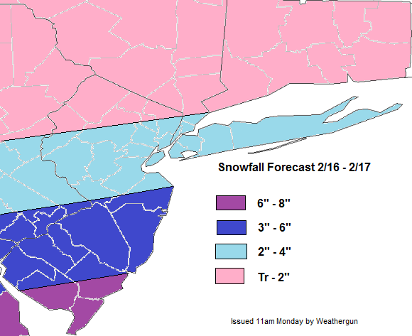
The past weekend storm once again, produce less snowfall many areas. Exception here in is Central and Southern NJ, where the inverted trough unexpectedly setup there. I will do some post-mordem on it this week. But another winter storm is already on it’s way for tonight. The snowfall forecast is after the end of this discussion.
A low pressure that is producing snow and ice over Central Plains and the Tennessee Valley, will stay south of the area through early this evening. Then as an upper-level low over the Canadian Martimes to lifts out, this storm will head more northeast towards the area tonight. The question here, is how much room will this storm have to come northward? Enough confluence from the upper-level low could lead to sharp cut-off of snowfall totals in the Tri-State area. Models are also indicate that 500mb shortwave energy for this system will tend to weaken a bit as moves into the Ohio Valley and Mid-Atlantic. However, there is fairly strong 700-8500mb southwesterly jet associated with this system. This could help enhance warm-air advection on top very cold airmass, currently in place. There some models on amount of lift and moisture that will be able to make to parts of Tri-State area. Also snow to rain ratios will be higher with very cold airmass aloft. The snow growth region ins 10C-20C layer. Ratios could be as high 25 to 1, especially if more lift and moisture is realized.
This is not a very powerful or explosive Nor’easter type storm. The southern stream system that will tapping to more Gulf of Mexico moisture then many of our systems have this season. However, it will be a fast-moving system, with not enough of blocking in the Atlantic. Snow will move in from southwest later this evening and last through early tomorrow morning. Snow will have difficult time making far north into the Hudson Valley and CT. While snow be steadier and heavier the farther south, especially over Central and Southern NJ. Snow should mid to late morning for all areas and skies should clear in the afternoon.