Coastal Storm Snowfall Forecast 1/24/15

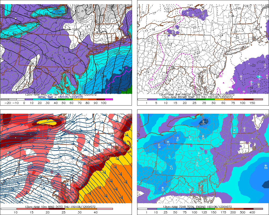
Snowfall forecast 11:30am 1/25 Update: The model guidance has trended with faster developing trough of warm of air aloft (TROWAL) and cold-conveyor belt with this storm. This means higher totals areas further Northwest. Also the cold-conveyor belt (CCB) tracks further east tomorrow over the area. For example, the 12z NAM model show below decent vertical velocities or lifting that and boundary level temperatures cooling enough for bands moderate snow late tomorrow afternoon for much of the area. Right now, I see this making for loss snowfall accumualtion with the changeover to rain in the morning for coastal areas. But I will monitor any stronger model trends with this CCB.

namNE_700_vvel_033

Snowfall Map 2

 From last night:

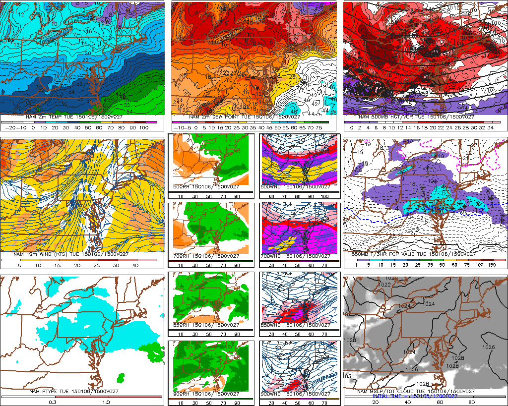
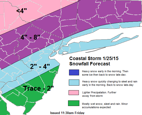
Snowfall forecast below for Saturday’s coastal storm you probably have heard about. Precipitation should arrive early Saturday morning and continue through most of the day. As with ever potential winter storm, there number things that often need to come together for a significant snowfall in the Tri-State. Especially for New York City and coastal sections. Here are some pros and cons for this storm that I see below. Based on the today’s model guidance:

Pros for snowfall

1. Surface and 850mb lows track south and east of area of the tri-state area.

2. Enough cold air already in place.

Cons for snowfall

1. No strong, cold high pressure to the north to keep cold air or setup a thermal gradient.

2. Not enough blocking in Atlantic, to force a slower moving storm

3. Phasing with northern stream occurring late.

4. Ridge more over the Pacific instead over the West Coast of North America.

Consider there are more pros and cons here. My forecast has light to moderate snowfall totals at best. Despite the low deepening into 980-990mbs, this storm matures to late for most of our area. Over interior Central and Eastern CT, this storm will start develop enough, that some heavy rates of snow may be possible. Comeback for more updates to this forecast and some model analysis  tonight or tomorrow. As well an update for another threat for snow early next week!

Snowfallmap1

A Little Snow and Bitter Cold Coming This Week

So far this winter, hasn’t feature alot of cold and snow. December ended on average warmer than normal for most of the United States. A short, simple explanation for it is that our source regions  for cold the AO and EPO where positive for better of the month.  However that patten has reversed for beginning of January. The EPO has gone negative and this is causing more an arctic blast to invade in to United States this week.

A strong cold front has passed through the area overnight. Temperatures have already fallen into middle 30s to lower 40s in most areas and gradually fall into upper 20s to lower 30s this afternoon. Northwest winds will be sustained between 15mph to 30mph with gusts possibly up to 40mph this afternoon. Windchills later this afternoon could in the lower 20s or teens. Temperatures tonight will get down in the upper teens and lower 20s in most areas, winds still gusty.

A clipper system will bring some light snow tomorrow. However, as with most clippers, moisture is limited. The upper-level shortwave will be passing to our south. The 850mb thermal advection will be near Mason-Dixon line. This means the best lifting will be over Southeast PA and Southern NJ. Expecting most of the tri-state area too see any from coating to 1″ of snow. Parts of Central and Southern NJ and Southeast to East-Central Pennsylvania could see up to 2 inches of snow.

The 12z NAM showing light snow with weakening clipper system on Tuesday

Behind this clipper, Wednesday will sunny with highs in middle to upper 20. Another cold front will bring a bitter colder airmass Wednesday night. 850mb temperatures below -20C support surface temperatures to drop into the middle to upper single digits on Thursday morning. Record lows for Thursday are in the lower single digits. So it’s not likely we will break them. Windchills are likely be below zero. A cold front with a reinforcing shot of cold air, behind it, could give some snow showers on Friday. Early look at this weekend, features a cold and dry on Saturday. With some moderation possible on Sunday. Another post will be coming soon on a review of this winter so far and what is in store for the rest of this winter

12zNAMf72

Nor’easter Impacts 12/09/14 – 12/10/14

The National Weather Service out of Upton, NY has issued a high wind watch tomorrow for New York City, Long Island, Lower Westchester and Coastal Connecticut, for possibly damaging wind gusts 55mph to 60mph. The map below is what I expect for wind gusts tomorrow, over the tri-state area. This storm will track slow northward off the Mid-Atlantic coast during the day tomorrow. Then move over Long Island tomorrow evening. Ahead of a strong LLJ with winds 60kt-80kts between 850bmb (5000 ft) and 925mb (2500 ft) will be push into region late tomorrow morning and afternoon. Inversion at this level will keep much of this winds mixing down. However models show 40kt-60kt (45mph-70mph) winds (highest farther south and east) with a mixed-layer around 975mb (1500ft). Bands of heavy rain will also help bring these winds down. These winds gradually weaken across the area late tomorrow afternoon and evening, as the storm starts to occlude and weaken. Rain will continue more intermittent at times tomorrow night. Some parts of the Interior could see some snow and ice tomorrow night and it turns colder. More updates on rain/wintry impacts will be coming later today.Peak Wind Gust Forecast 1210