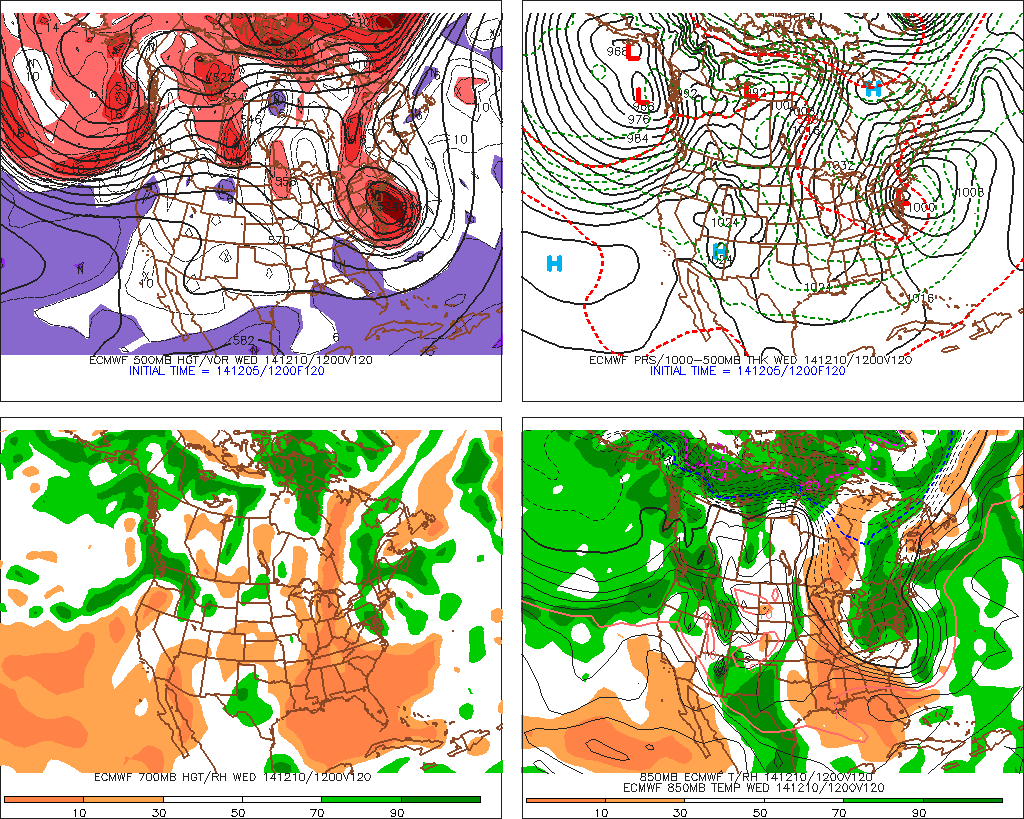
Model guidance is showing the potential for another nor’easter developing for Monday night and Tuesday of next week. But model guidance vary run to run with details. At this range, it’s important to look at what being more consistently shown or agreed upon vs what is being less consistent or agreed upon. On all the reliable models, there is a strong ridge developing over Western US that will cause a trough to dig and amplify over the Eastern US. The models are varying run to run on the timing and amount of interaction or phasing of polar, pacific and subtropical disturbances. In general, more phasing of all disturbances would bring a bigger winter storm for Mid-Atlantic and Northeast regions. While less phasing will result a weaker storm further east. Perhaps only significantly impacting New England.
There is also a strong, cold high pressure near or over Newfoundland during the duration of this event. This high is building in response to trough amplification along the Eastern US and another very deep low over the North Atlantic Ocean, This is not favorable position for significant snowstorm for the coastal plain. First, this supports winds out the northeast to east direction. This often results in warmer air off ocean keep areas near the coast being predominately rain. Including the major cities along the I-95 corridor. While areas further inland remain colder and have more potential to see more snowfall or mixed precipitation. Second the high in this position, also gives room for the storm to track further west and bring ever more warmer at surface and aloft. Third the strong high will cause a very tight pressure gradient if this storm materializes. There is a potential here for wind gusts over 40mph and some coastal flooding with the full moon early next week.
However, there is a possibly that enough cold wraps behind this storm, that if were to track east of the area, rain change to snow for the coastal areas. The scenario highly dependent on if, when and how much polar energy from the trough near the Great Lakes. If this energy were to phase, it will also more amplification and pull or retrograde the storm further west. If this occurs to late, storm could remain far enough east with the development of cold-conveyor belt (CCB), causing rain to change over to snow down to the coast. This is scenario that will monitored through this weekend.
A quick run down on the most reliable models:
The 12z ECMWF has phasing all three disturbances. A 500mb closed forms over Mid-Atlantic coast, with low pressure track over New Jersey. Behind this closed low, is a CCB that has formed over the Northern Mid-Atlantic region.
 The 12z UKMET appears to have a similar solution to the ECMWF. Closed 500mb over Mid-Atlantic coast.. The low is likely being pulled back to the coast:
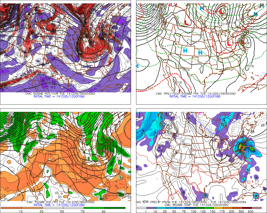
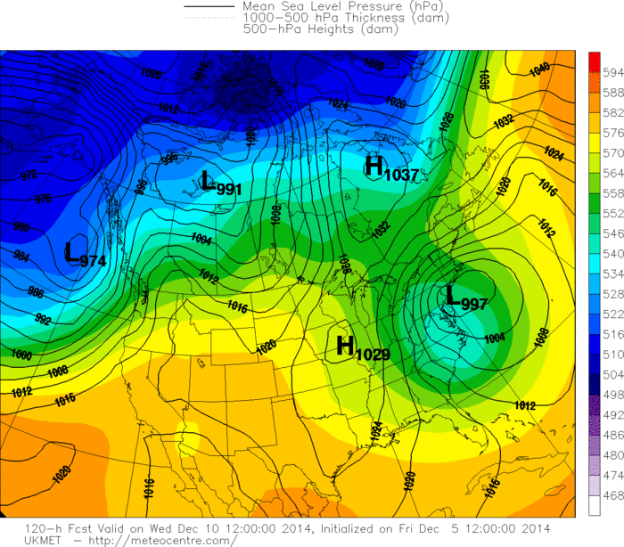 The 12z GGEM has more phasing with the polar disturbance. However, it has the storm taking an inland track. That brings milder air at the surface and alot over the Tri-State area. But before that happens, a colder airmass is in place. So precipitation on Monday, comes in as snow, particularly for parts of Northern New Jersey and Lower Hudson Valley.
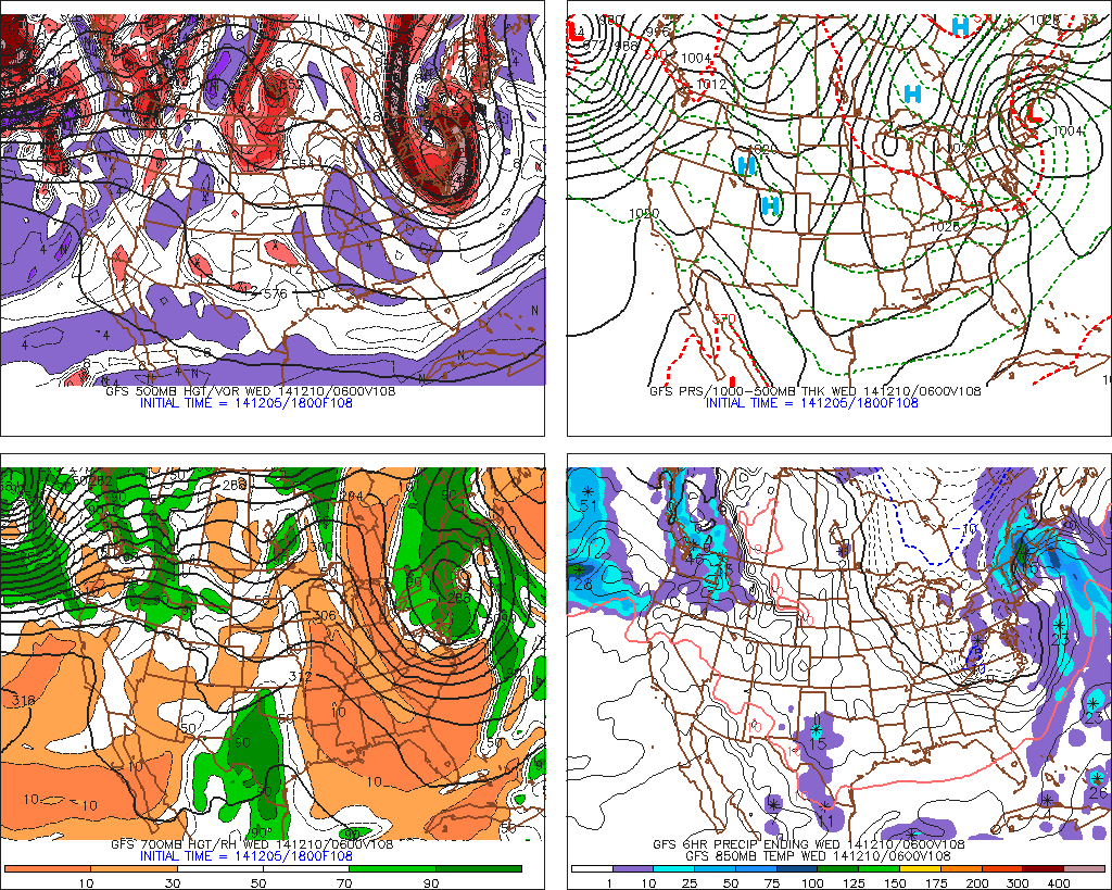
The 18z GFS phases the polar, pacific, and subtropical disturbances later than rest of models. The 500mb low is closing off over the southeast New York and New Jersey. The surface low is being pinwheeled back over Eastern New England. This solution would have the least impacts for the tri-state area.
At this time, I favor the more phased ECMWF and UKMET solutions. The GFS and GGEM often do not handle the phasing well with East Coast storms. However, we likely won’t be honing down too many details until Sunday afternoon. Stay tuned here for more updates on the model guidance through the weekend.