Guidance has coming into consensus for a major storm along the East Coast, Wednesday night and Thursday. The main questions are the exact track and intensity of this storm. Cold high pressure will be sliding offshore of New England on Wednesday night. This means support for cold air to remain place will be weakening, ahead of this storm. If the storm takes track too close to coast, coastal sections will likely changeover to sleet and rain and less snowfall. While heavy snow continues further inland. However, if this storm intensifies rapidly and tracks just far east, they may only be a brief mix or changeover for the coast, before going back to heavy snow.
Features that need to be watched over the next 24hrs:
1. The low coming in Midwest (the kicker). The timing, strength, and placement of this low can have number of impacts on the east coast storm. This system, if stronger and faster, could lead to slower development of the storm or further east track
2. The 500mb low. The sooner this low closes off, the slower, stronger, and farther west this storm will be. A closed 500mb low to south or east, is favorable for major snowstorm for the tri-state area.
3. The 700mb and 850mb lows. Where these features track are important for frontogenesis and cold-conveyor belt formation in our area. Heavier snow is favored anywhere to north and west of these lows. While more warm air or dry air intrusion, favored to south and east.
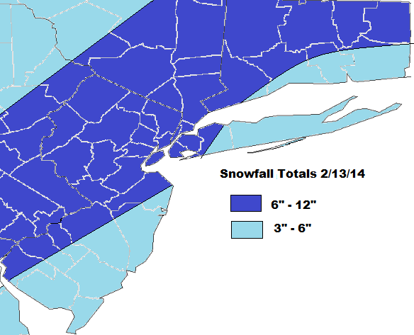
Much of the guidance today shows these mid-level lows closing off and track from Delmarva NE to Southern New England. This should put the heaviest snowfall from I-95 major cities N&W. Further S&E will snow see more sleet, rain, and dry air decreasing snowfall totals. The preliminary snowfall total map is below:
Besides snow, this storm may have other minor or moderate impacts. Such has high winds gusts to 40mph and minor tidal flooding along the coast:


