Mid-Late March Outlook – Is Winter Over?

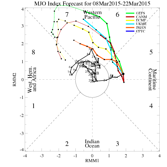
After the MJO/tropical weakened during the last week of February, the pacific pattern changed to -PNA pattern. The west ridge retrograded into NE Pacific. However, this also kept the EPO negative and support for a cross-polar flow into US. So the first five days features wintry threats. Including one that gave many parts of the 4″ to 8″ of snow on Thursday, March 5th. We have now finally much warmer temperatures today and for much of this week.Well, enjoy it, because it now looks the MJO will be picking up later this month.. Model forecasts are for the MJO to progress and become very strong into between phases 7 and 8. If we reach phases 8, this support a cooler and stormier pattern to return around or after March 20th:

ALL_emean_phase_full

The +PDO still looks favorable for more -EPO/+PNA pattern to continue to reload into early Spring. The -QBO continues to fall as the  February value was -28.62. This could lead to more planetary waves impacting the the polar vortex. So even if MJO or tropical forcing doesn’t last long, the +PNA (west coast ridge) will likely return and there are some signs of the NAO may go negative for period as well. As we get later in March, climatology favors less snow for the coastal plain. However, the potential for anomalous pattern to show up again, we can’t rule out entirely another moderate or significant snowfall threat for even the coast. Stay tuned

The 12z GEFS showing +PNA pattern around March 20th
The 12z GEFS today  showing +PNA pattern evolving around March 20th

Snowfall Forecast for Winter Storm 3/01-3/02 Updated

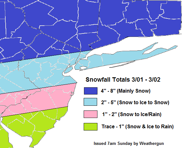
Snow will overspread the area from southwest to northeast later this morning and this afternoon. Latest NAM and RGEM show snow changing to sleet then freezing rain for many areas NYC and south and east this evening. However, warm air advects northward, between 850-925mb, the thermal gradient will be increasing at this level. This could enhance lifting for a period of moderate to heavy snow before this changeover occursover North-Central NJ, New York City and Long Island. If this changeover before 7pm,then 2″ or 3″ is more likely to occur. If the changeover is delayed just an hour or two 4″ or 5″ are more likely. This even more likely over north shore of LI, parts northern parts of five boroughs, and just north and west of Newark, NJ. Further north over Northernmost New Jersey, the Lower Hudson Valley, and Connecticut is still likely to remain snow. Models since yesterday have increased liquid totals for most of the area. More freezing rain also likely parts for the southern half New Jersey,  before a change to rain.  As surface temperatures will be slow to rise to just above freezing. The forecast below has been updated to reflect these changes. Snowfallmap301-027amsun

Snowfall Forecast for 3/01-02 Winter Storm

The latest models appear to becoming together on colder and wetter solution for the Tri-state on Sunday afternoon and night. The shortwave trough will cause weak low to from just off the New Jersey or Delaware shores. This will transport more moisture into area and cause the warm front to lift more slowly through region. A strong 700mb-850mb west-southwest jet will also enhance a thermal gradient that will enhancing lifting. At this time, appears most likely over NE NJ, NYC and LI. Models soundings show a warm layer near 900mb that will cause change over to freezing rain for a few hours Sunday evening, in these areas. Before ending as some light snow around daybreak Monday.Just north of this gradient is where precipitation is likely to fall mainly in the form of snow. Although, it’s not of the question some parts of there is brief mix with sleet/freezing rain.

The 12z GFS showing nose of 40-50kt+ jet at 700mb (10,000 ft)
Today’s 12z GFS today showing the tri-state area on the nose if 40-50kt+ jet at 700mb (10,000 ft)

The forecast below a blend of American and Canadian models. Leaning more toward NAM thermal profiles and leaning more towards RGEM/GGEM and GFS liquid forecasts.  So this forecast may be update later tonight, after viewing more guidance:


Snowfallmap301-02

The storm late Tuesday and Wednesday still appears to track over Ohio Valley and Great Lakes. This will cause any frozen precipitation to quickly changeover to rain in our area. However, latest models are indication that this storm’s cold front may slow down  with more waves forming along it Wednesday night and Thursday. The outcome comes to the placement of the frontal boundary, the timing of waves moving up the front and whether the upper-level trough can take a more neutral or negative tilt. I will keep an eye on it and hopefully have another update later.