Severe Thunderstorms Hit Long Island 7/15/14

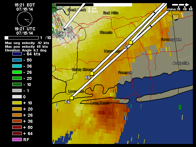
This past week, we had a storm event, wasn’t a big severe weather or tornado outbreak that was being suggested by other sources for Northeast and Mid-Atlantic regions. But there were some severe thunderstorms for a parts of the area. These are base velocity radar images from thunderstorms that hit Long Beach and and Jones Beach in Long Island, New York. These storms produced wind gusts up to 60mph near Point Lookout, knocking down trees over parts Nassau and Suffolk Counties. Heavy rainfall from these t-storms also caused localized flash flooding.

Image courtesy of Weather Underground.
Base Velocity loop showing strong winds, courtesy of Weather Underground.

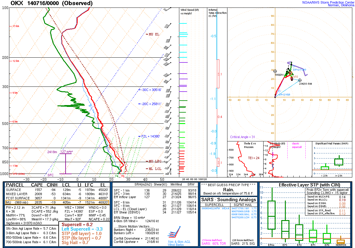
It’s not a relative common occurrence, for severe thunderstorms on Long Island. As the marine layer from a wind direction off the ocean waters, tends to cause thunderstorms to collapse as they approach the coast. However, on Tuesday a cap was present and winds were out southwest direction (over more land). Which allowed more instability to develop, with some sunshine. The  sounding below, is from a balloon launch Tuesday evening, from the National Weather Service office in Upton, NY showed 2009 J/kg of MLCAPE (mixed-layer cape). That is high amount of buoyancy in the lowest 100mb layer for this area. This instability also was juxtaposed with 31kts of 0-6km shear and 29kts of 0-1km shear. Which contributed to more organized and stronger updrafts and downdrafts in thunderstorms.

OKX Sounding from balloon launch at 8pm Tuesday 7/15/14
OKX Sounding from balloon launch at 8pm Tuesday 7/15/14 

Potential for Severe Thunderstorms Late Today

The Storm Prediction Center has issued a slight risk of severe thunderstorms for far western parts of the area today. The rest of the area including the Northeast NJ, NYC and Long Island area are in a lower 5% risk for thunderstorms producing damaging wind gusts and large hail. An upper-level trough and cold front approaching from the west, will trigger showers and thunderstorms, late this afternoon and this evening. With a humid airmass in place and temperatures rising into lower to middle 90s today away from the shore, the atmosphere will become very unstable some of those thunderstorms to possibly become strong or severe.

Storm Prediction Center outlook for 13z Wednesday, shows slight risk for parts Upstate NY, Pennsylvania, and Extreme Western Nj
Storm Prediction Center outlook for 13z Tuesday, shows slight risk for parts Upstate NY, Pennsylvania, and Extreme Western Nj

The severe threat is greatest over Upstate New York, Pennsylvania and extreme Northwest New Jersey. Where they will be closer to an embedded 500mb shortwave trough and a 40-60kt southwesterly low-level jet streak late this afternoon and early evening. Both features will enhance shear and lift for more organized severe thunderstorms that can produce damaging winds, large hail and isolated tornadoes.  For areas closer to to I-95 corridor, with less shear and lifting later today, the threat for severe thunderstorms with damaging winds and large hail is more isolated.

12z NAM showing 40-60kt 850mb jet
Today 12z run of the NAM showing 40-60kt 850mb jet over Upstate New York  and Pennsylvania (image courtesy of College of DuPage)

The cold front will move through area tonight and tomorrow, with more showers and thunderstorms with heavy downpours. Shear and lifting will be more sufficient. But a slightly cooler and drier airmass behind front, will mean less instability for severe thunderstorms. For more organized, widespread severe thunderstorms, sufficient lifting, shear, instability, and moisture need to all come together. But forecasting how all these ingredients will come together for severe, is hardly ever simple in Northeast US, even on the same day of threat.  For this reason, I will continue to monitor this potential here today and tomorrow.

Warm, Humid & Storms Today. More Rain & Storms Possible Wednesday Night & Thursday

With a southerly flow, today will be warmer and more humid for Tri-State area. Temperatures will rise into middle to upper 80s this afternoon, away from the coast. Scattered showers and thunderstorms will develop along trough axis approach from the west this afternoon. Best chances for showers and thunderstorm will be north and west of New York City, where lift and instability will be higher. Model forecast soundings show sufficient SBCAPE for thunderstorms to become strong this afternoon. However, weak vertical shear and poor mid-level lapse rates will limit storm organization and intensity. Also with the weak flow and PWAT near 1.80″, any thunderstorms will be moving slowly and capable of producing very heavy rainfall. Which could result in some flash flooding. Showers and thunderstorms should gradually diminish tonight. As the trough axis shifts east and instability decreases after sunset.

6z NAM model sounding for Trenton, NJ late this afternoon, for high SBCAPE, weak shear & pwat 1.77"
6z NAM model sounding for Trenton, NJ late this afternoon, for high SBCAPE, weak shear & pwat 1.77″

Tomorrow we will see more sunshine. But it will not be as warm and humid. A weak cold front will slowly pass through the area. Temperatures will still take run at 80 or above, with a deep NW flow and steepening lapse rates. A strong cap aloft will likely suppress shower and thunderstorm development during the afternoon and early evening hours.

6z NAM showing strong capping inversion tomorrow
6z NAM model sounding showing strong capping inversion tomorrow

Later tomorrow night into Thursday could get more stormy. A potent shortwave and wave low of pressure that will producing severe weather over Central Plains today and Ohio Valley tomorrow, will moving across our region. There are some models differences on the exact timing and track of this wave through our area. If this wave, tracks over Central or Southern New Jersey, it could give many of us period of heavy rain with embedded, elevated thunderstorms. A track further north than that, would put more of the in warmer, unstable airmass and vertical wind shear. Which would support strong to severe thunderstorms. At this time, much the guidance favors the southern track. But as the begins develop over Central Plains today, this could still be some changes. Stay tuned for another update late tonight or early tomorrow.