Coastal Storm to Bring Heavy Rain and Winds to The Tri-State Area

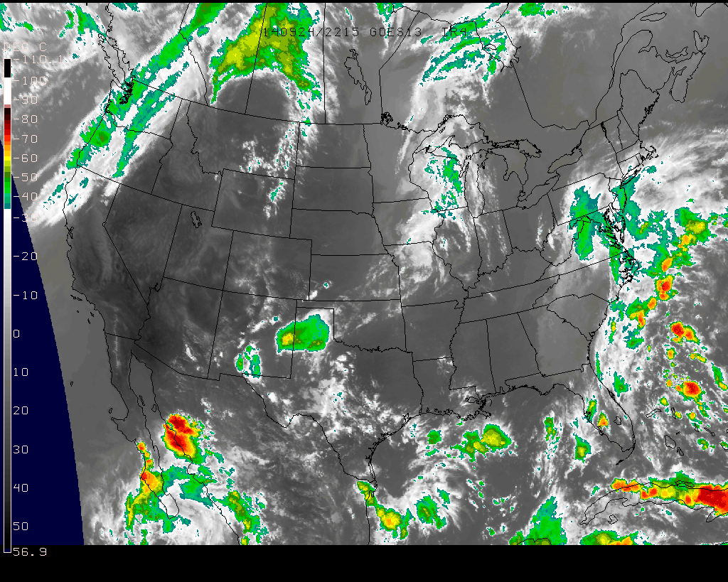
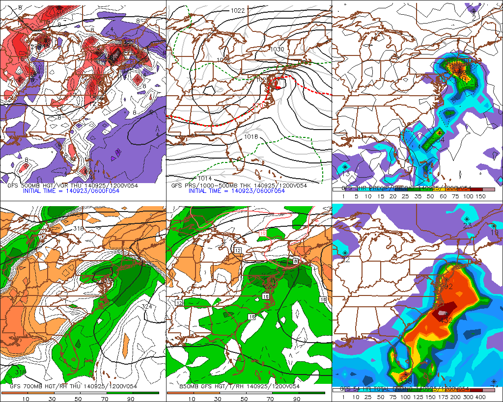
Coastal storm is now taking shape along the East Coast. It’s weak, disorganized storm. But this system is pulling lots of moisture from the Atlantic and Gulf of Mexico. This will give parts of Tri-state area some heavy rainfall. A strong high east of New England will also create a tight pressure gradient between this system.  Resulting in windy conditions and some minor coastal flooding tomorrow as well. Check out more details below.

et0z3

Rainfall Totals:

There is some uncertainty, in how much rain will fall out this system. The model guidance is struggling with areas of convection off the east coast and some subsidence over Northeast. Right 1-2″ seems to be good bet for much the area. However amounts may vary greatly from area to area, depending on how heavy rain bands move through the area. Most guidance has good theta- advection and frontogensis with very high precipitable water values, lifting northward through the area late tonight and tomorrow. This is when heaviest rainfall will likely occur. Tomorrow afternoon these dynamics begin to weaken and lift northward. So some periods of lighter rain and drizzle is expected. This may linger into tomorrow night for Derek Jeter’s last home game at Yankee Stadium. But I think they will probably still play.

Rainfall Totals 092514

Winds & Coastal Flooding:

The low pressure with this storm is weak. But with a strong high east of New England, there will be a tight pressure gradient. This will cause winds out the east to northeast to increase between 25 to 35mph with gusts up 45mph,  along the New Jersey, Long Island and Connecticut shores. Just inland winds over NYC, Northeast NJ and Long Island will 15 to 25mph with gusts to 35mph. Further northwest winds will be weaker. With the new moon, these winds will cause some minor coastal flooding at high tides tonight and tomorrow morning. As well as some high waves and rip currents at the shore too. Buoy 44009 about 25 miles southeast of Cape May, NJ is already report waves up to 10ft this evening.

Wind Forecast 092514

Significant Coastal Storm Possible Wednesday Night and Thursday

High pressure will be over East today. Bringing party sunny skies. With light onshore winds highs temperatures will only be upper 60s to near 70 today. Enjoy because the weather make take turn for the worst starting tomorrow night.

This high pressure will begin to weaken and slide east into Nova Scotia on Wednesday. This will allow low pressure developing off the Southeast US, to track northward up the Mid-Atlantic coast. There are some differences in the guidance in how they handling this system. But the overall trend past three runs has been further north. Clouds will likely increase on Wednesday, with some rain overspreading the area from north to south Wednesday night and into Thursday.

A few things to watch here, before I hone in on details. First, how strong is subsidence or high pressure will be in this area. This will be a factor in how rainfall we receive. Most guidance seems to show heavy band of rain making as for north as Central New Jersey before weakening. Although this morning’s 6z GFS and it’s ensembles have coming with an even wetter solution.  Sea-surface temperatures off the east running warmer than normal. This may enhance more deepening of coastal storm than what models show. As was seen with Sunday’s coastal storm that was a near miss for the Tri-state area.

6z GFS from overnight showing coastal storm over Delmarva with rain over the Tri-State area. Wettest soultion
6z GFS from overnight showing coastal storm over Delmarva with heavy rainfall over the Tri-State area. Wettest solution

There will also be tight pressure gradient developing with strong high pressure north of this low. This could cause winds out the east to northeast to increase near the coast Wednesday night How strong these winds be in the area will depend on the intensity and track of the low. Some high surf and rip currents are likely over the ocean. There will also be new moon on Thursday. So minor coastal flooding at high tides is possible. I will have more updates and details here are coming as new guidance comes today.

This storm will begin to weaken and drift slowly away from the Tri-state area later Thursday afternoon. Leaving behind perhaps a few some scattered light showers for the Derek Jerek’s last home game at Yankee Stadium night. Friday and this weekend are looking better  with high pressure building back over the Central and Eastern US. Temperatures will begin moderate to above normal. Perhaps near 80 degrees, away from the coast.

Hurricane Odile Slams into Baja California, Edouard Almost A Major Hurricane

Check out previous posts on Odile and Edouard over the weekend at Tropics.

Odile made landfall near Cabo San Lucas, MX as major category 3 hurricane with maximum sustained winds at 125mph at about 925pm PDT. An automated station on Cabo San Lucas reported a sustained wind at 89mph and  a 116mph gust, near the time of landfall. Odile has significantly weakened today, while moving inland over Baja California. Maximum sustained winds are now 80mph, as of the 5pm advisory from the National Hurricane Center today. Odile is the strongest hurricane to make a direct hit on the Cabo San Lucas area, and from images today,  appears it had devastated parts of the area. Some major damage has been reported. Just give you an idea of magnitude of this storm, below are some rainbow animated loops of Odile just before and after making landfall and some pictures of devastation from people in the area.

 rbtop-animated2

CaboSanLucasdamage1Damage2Damage3Odile is likely weaken to remnant low, over next couple days. A trough moving California may carry Odile’s remnants into Southwest US, later this week. Meanwhile Hurricane Edouard, is still going well out in the Atlantic (as shown below) it is almost category 3 hurricane with maximum sustained winds at 110mph, as of the 5pm advisory from the National Hurricane Center. Satellite image shows an a large eye has cleared out and is surrounded by ring of deep convection. This is a good sign of hurricane intensifying and Edouard will likely become a category 3 later tonight. Edouard still expected recurve into North Atlantic. However a wave model shows some 3 to 4 feet swells impacting the East Coast on Wednesday.

rbtop-animated